Saint-Brès, Hérault
show This article may be expanded with text translated from the corresponding article in French. (January 2017) Click [show] for important translation instructions. |
Saint-Brès | |
|---|---|
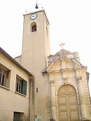 The church of Saint-Brès | |
 Coat of arms | |
show Location of Saint-Brès | |
 Saint-Brès | |
| Coordinates: 43°40′06″N 4°01′48″E / 43.6683°N 4.03°ECoordinates: 43°40′06″N 4°01′48″E / 43.6683°N 4.03°E | |
| Country | France |
| Region | Occitanie |
| Department | Hérault |
| Arrondissement | Montpellier |
| Canton | Le Crès |
| Intercommunality | Montpellier Méditerranée Métropole |
| Government | |
| • Mayor (2020–2026) | Laurent Jaoul |
| Area 1 | 4.86 km2 (1.88 sq mi) |
| Population (Jan. 2018)[1] | 3,006 |
| • Density | 620/km2 (1,600/sq mi) |
| Time zone | UTC+01:00 (CET) |
| • Summer (DST) | UTC+02:00 (CEST) |
| INSEE/Postal code | 34244 /34670 |
| Elevation | 13–41 m (43–135 ft) (avg. 23 m or 75 ft) |
| 1 French Land Register data, which excludes lakes, ponds, glaciers > 1 km2 (0.386 sq mi or 247 acres) and river estuaries. | |


Saint-Brès (French pronunciation: [sɛ̃ bʁɛs]; Occitan: Sant Breç) is a commune in the Hérault department in the Occitanie region in southern France.
Population[]
| Year | Pop. | ±% |
|---|---|---|
| 1962 | 438 | — |
| 1968 | 573 | +30.8% |
| 1975 | 1,094 | +90.9% |
| 1982 | 1,515 | +38.5% |
| 1990 | 1,958 | +29.2% |
| 1999 | 2,477 | +26.5% |
| 2008 | 2,638 | +6.5% |
See also[]
References[]
- ^ "Populations légales 2018". INSEE. 28 December 2020.
| Wikimedia Commons has media related to Saint-Brès (Hérault). |
This Hérault geographical article is a stub. You can help Wikipedia by . |
Categories:
- Communes of Hérault
- Hérault geography stubs