Saint-Drézéry
Saint-Drézéry | |
|---|---|
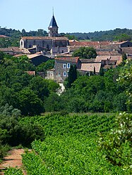 A general view of Saint-Drézéry | |
 Coat of arms | |
show Location of Saint-Drézéry | |
 Saint-Drézéry | |
| Coordinates: 43°44′03″N 3°58′58″E / 43.7342°N 3.9828°ECoordinates: 43°44′03″N 3°58′58″E / 43.7342°N 3.9828°E | |
| Country | France |
| Region | Occitanie |
| Department | Hérault |
| Arrondissement | Montpellier |
| Canton | Le Crès |
| Intercommunality | Montpellier Méditerranée Métropole |
| Government | |
| • Mayor (2020–2026) | Jackie Galabrun-Boulbes[1] |
| Area 1 | 10.47 km2 (4.04 sq mi) |
| Population (Jan. 2018)[2] | 2,630 |
| • Density | 250/km2 (650/sq mi) |
| Time zone | UTC+01:00 (CET) |
| • Summer (DST) | UTC+02:00 (CEST) |
| INSEE/Postal code | 34249 /34160 |
| Elevation | 60–145 m (197–476 ft) (avg. 86 m or 282 ft) |
| 1 French Land Register data, which excludes lakes, ponds, glaciers > 1 km2 (0.386 sq mi or 247 acres) and river estuaries. | |


Saint-Drézéry is a commune in the Hérault department in the Occitanie region in southern France.
Population[]
| Year | Pop. | ±% |
|---|---|---|
| 1962 | 523 | — |
| 1968 | 555 | +6.1% |
| 1975 | 574 | +3.4% |
| 1982 | 1,017 | +77.2% |
| 1990 | 1,329 | +30.7% |
| 1999 | 1,754 | +32.0% |
| 2008 | 2,117 | +20.7% |
See also[]
References[]
- ^ "Répertoire national des élus: les maires". data.gouv.fr, Plateforme ouverte des données publiques françaises (in French). 2 December 2020.
- ^ "Populations légales 2018". INSEE. 28 December 2020.
| Wikimedia Commons has media related to Saint-Drézéry. |
This Hérault geographical article is a stub. You can help Wikipedia by . |
Categories:
- Communes of Hérault
- Hérault geography stubs