Saint-Paul-et-Valmalle
Saint-Paul-et-Valmalle | |
|---|---|
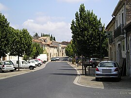 The main road in Saint-Paul-et-Valmalle | |
 Coat of arms | |
show Location of Saint-Paul-et-Valmalle | |
 Saint-Paul-et-Valmalle | |
| Coordinates: 43°37′38″N 3°40′32″E / 43.6272°N 3.6756°ECoordinates: 43°37′38″N 3°40′32″E / 43.6272°N 3.6756°E | |
| Country | France |
| Region | Occitanie |
| Department | Hérault |
| Arrondissement | Lodève |
| Canton | Gignac |
| Intercommunality | Vallée de l'Hérault |
| Government | |
| • Mayor (2020–2026) | Jean-Pierre Bertolini[1] |
| Area 1 | 12.72 km2 (4.91 sq mi) |
| Population (Jan. 2018)[2] | 1,185 |
| • Density | 93/km2 (240/sq mi) |
| Time zone | UTC+01:00 (CET) |
| • Summer (DST) | UTC+02:00 (CEST) |
| INSEE/Postal code | 34282 /34570 |
| Elevation | 110–341 m (361–1,119 ft) (avg. 140 m or 460 ft) |
| 1 French Land Register data, which excludes lakes, ponds, glaciers > 1 km2 (0.386 sq mi or 247 acres) and river estuaries. | |


Saint-Paul-et-Valmalle (Languedocien: Sant Pau e Valmala) is a commune in the Hérault department in the Occitanie region in southern France.
Population[]
| Year | Pop. | ±% |
|---|---|---|
| 1962 | 267 | — |
| 1968 | 272 | +1.9% |
| 1975 | 315 | +15.8% |
| 1982 | 385 | +22.2% |
| 1990 | 593 | +54.0% |
| 1999 | 754 | +27.2% |
| 2008 | 904 | +19.9% |
See also[]
References[]
- ^ "Répertoire national des élus: les maires". data.gouv.fr, Plateforme ouverte des données publiques françaises (in French). 2 December 2020.
- ^ "Populations légales 2018". INSEE. 28 December 2020.
| Wikimedia Commons has media related to Saint-Paul-et-Valmalle. |
This Hérault geographical article is a stub. You can help Wikipedia by . |
Categories:
- Communes of Hérault
- Hérault geography stubs