Guzargues
Guzargues | |
|---|---|
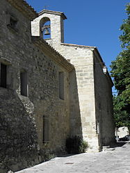 The parish church of Saint-Michel in Guzargues | |
 Coat of arms | |
show Location of Guzargues | |
 Guzargues | |
| Coordinates: 43°43′24″N 3°55′32″E / 43.7233°N 3.9256°ECoordinates: 43°43′24″N 3°55′32″E / 43.7233°N 3.9256°E | |
| Country | France |
| Region | Occitanie |
| Department | Hérault |
| Arrondissement | Lodève |
| Canton | Saint-Gély-du-Fesc |
| Government | |
| • Mayor (2020–2026) | Pierre Antoine[1] |
| Area 1 | 11.73 km2 (4.53 sq mi) |
| Population (Jan. 2018)[2] | 505 |
| • Density | 43/km2 (110/sq mi) |
| Time zone | UTC+01:00 (CET) |
| • Summer (DST) | UTC+02:00 (CEST) |
| INSEE/Postal code | 34118 /34820 |
| Elevation | 80–209 m (262–686 ft) (avg. 97 m or 318 ft) |
| 1 French Land Register data, which excludes lakes, ponds, glaciers > 1 km2 (0.386 sq mi or 247 acres) and river estuaries. | |


Guzargues (French pronunciation: [ɡyzaʁɡ]; Occitan: Gusargues) is a commune in the Hérault département in the Occitanie region in southern France.

Map
Population[]
| Year | Pop. | ±% |
|---|---|---|
| 1962 | 108 | — |
| 1968 | 116 | +7.4% |
| 1975 | 118 | +1.7% |
| 1982 | 149 | +26.3% |
| 1990 | 178 | +19.5% |
| 1999 | 344 | +93.3% |
| 2008 | 423 | +23.0% |
See also[]
References[]
- ^ "Répertoire national des élus: les maires". data.gouv.fr, Plateforme ouverte des données publiques françaises (in French). 2 December 2020.
- ^ "Populations légales 2018". INSEE. 28 December 2020.
| Wikimedia Commons has media related to Guzargues. |
This Hérault geographical article is a stub. You can help Wikipedia by . |
Categories:
- Communes of Hérault
- Hérault geography stubs