Mourèze
Mourèze | |
|---|---|
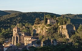 The village. | |
show Location of Mourèze | |
 Mourèze | |
| Coordinates: 43°37′12″N 3°21′24″E / 43.62°N 3.3567°ECoordinates: 43°37′12″N 3°21′24″E / 43.62°N 3.3567°E | |
| Country | France |
| Region | Occitanie |
| Department | Hérault |
| Arrondissement | Lodève |
| Canton | Clermont-l'Hérault |
| Intercommunality | Clermontais |
| Government | |
| • Mayor (2008–2014) | Gabriel Navas |
| Area 1 | 13.44 km2 (5.19 sq mi) |
| Population (Jan. 2018)[1] | 199 |
| • Density | 15/km2 (38/sq mi) |
| Time zone | UTC+01:00 (CET) |
| • Summer (DST) | UTC+02:00 (CEST) |
| INSEE/Postal code | 34175 /34800 |
| Elevation | 160–537 m (525–1,762 ft) (avg. 200 m or 660 ft) |
| 1 French Land Register data, which excludes lakes, ponds, glaciers > 1 km2 (0.386 sq mi or 247 acres) and river estuaries. | |


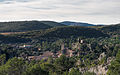
Mourèze is a commune in the Hérault department in the Occitanie region in southern France.
At the edge of the village is a spectacular dolomitic limestone outcrop known as the Cirque de Mourèze.
Population[]
| Year | Pop. | ±% |
|---|---|---|
| 1962 | 71 | — |
| 1968 | 81 | +14.1% |
| 1975 | 79 | −2.5% |
| 1982 | 76 | −3.8% |
| 1990 | 100 | +31.6% |
| 1999 | 128 | +28.0% |
| 2008 | 171 | +33.6% |
The Cirque de Mourèze is a steephead valley of which the chaotic appearance was made by the erosion of dolomite rocks.

An erosional remnant of dolomite in the Cirque de Mourèze


See also[]
References[]
- ^ "Populations légales 2018". INSEE. 28 December 2020.
| Wikimedia Commons has media related to Mourèze. |
This Hérault geographical article is a stub. You can help Wikipedia by . |
Categories:
- Communes of Hérault
- Hérault geography stubs