Candillargues
Candillargues | |
|---|---|
 Church | |
show Location of Candillargues | |
 Candillargues | |
| Coordinates: 43°37′15″N 4°04′08″E / 43.6208°N 4.0689°ECoordinates: 43°37′15″N 4°04′08″E / 43.6208°N 4.0689°E | |
| Country | France |
| Region | Occitanie |
| Department | Hérault |
| Arrondissement | Montpellier |
| Canton | Mauguio |
| Government | |
| • Mayor (2020–2026) | Anthony Melin |
| Area 1 | 8.23 km2 (3.18 sq mi) |
| Population (Jan. 2018)[1] | 1,797 |
| • Density | 220/km2 (570/sq mi) |
| Time zone | UTC+01:00 (CET) |
| • Summer (DST) | UTC+02:00 (CEST) |
| INSEE/Postal code | 34050 /34130 |
| Elevation | 0–7 m (0–23 ft) |
| 1 French Land Register data, which excludes lakes, ponds, glaciers > 1 km2 (0.386 sq mi or 247 acres) and river estuaries. | |


Candillargues (French pronunciation: [kɑ̃dijaʁɡ]; Occitan: Candilhargues) is a commune in the Hérault department in southern France.
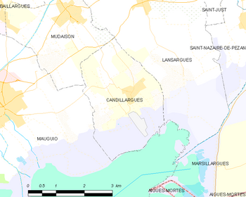
Map
Population[]
| Year | Pop. | ±% |
|---|---|---|
| 1962 | 286 | — |
| 1968 | 311 | +8.7% |
| 1975 | 292 | −6.1% |
| 1982 | 476 | +63.0% |
| 1990 | 687 | +44.3% |
| 1999 | 1,143 | +66.4% |
| 2008 | 1,269 | +11.0% |
History[]
During French revolution, Candillargues took the name Côme-de-la-Palus.
See also[]
References[]
- ^ "Populations légales 2018". INSEE. 28 December 2020.
| Wikimedia Commons has media related to Candillargues. |
This Hérault geographical article is a stub. You can help Wikipedia by . |
Categories:
- Communes of Hérault
- Hérault geography stubs