Ségur-le-Château
show This article may be expanded with text translated from the corresponding article in French. (January 2009) Click [show] for important translation instructions. |
Ségur-le-Château
Segur lo Chasteu (Occitan) | |
|---|---|
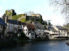 Buildings within Ségur-le-Château | |
 Coat of arms | |
show Location of Ségur-le-Château | |
 Ségur-le-Château | |
| Coordinates: 45°25′49″N 1°18′21″E / 45.4303°N 1.3058°ECoordinates: 45°25′49″N 1°18′21″E / 45.4303°N 1.3058°E | |
| Country | France |
| Region | Nouvelle-Aquitaine |
| Department | Corrèze |
| Arrondissement | Brive-la-Gaillarde |
| Canton | Uzerche |
| Government | |
| • Mayor (2020–2026) | Pierre-Louis Puygrenier |
| Area 1 | 9.48 km2 (3.66 sq mi) |
| Population (Jan. 2018)[1] | 184 |
| • Density | 19/km2 (50/sq mi) |
| Time zone | UTC+01:00 (CET) |
| • Summer (DST) | UTC+02:00 (CEST) |
| INSEE/Postal code | 19254 /19230 |
| Elevation | 270–397 m (886–1,302 ft) |
| 1 French Land Register data, which excludes lakes, ponds, glaciers > 1 km2 (0.386 sq mi or 247 acres) and river estuaries. | |


Ségur-le-Château (French: [seɡyʁ lə ʃɑto]; Occitan: Segur lo Chasteu) is a commune in the department of Corrèze in central France.
History[]
The viscounts of Limoges, also called the viscounts of Ségur created a small principality, whose last heir was Henry IV. Ségur was the main home of these viscounts, in the heart of their domain.
Population[]
| Year | Pop. | ±% |
|---|---|---|
| 1962 | 400 | — |
| 1968 | 401 | +0.2% |
| 1975 | 323 | −19.5% |
| 1982 | 304 | −5.9% |
| 1990 | 269 | −11.5% |
| 1999 | 247 | −8.2% |
| 2008 | 231 | −6.5% |
See also[]
References[]
- ^ "Populations légales 2018". INSEE. 28 December 2020.
| Wikimedia Commons has media related to Ségur-le-Château. |
| show Villages in the association Les Plus Beaux Villages de France |
|---|
| show Authority control |
|---|
This Corrèze geographical article is a stub. You can help Wikipedia by . |
Categories:
- Communes of Corrèze
- Plus Beaux Villages de France
- Corrèze geography stubs