Vogüé
show This article may be expanded with text translated from the corresponding article in French. (December 2008) Click [show] for important translation instructions. |
Vogüé | |
|---|---|
Commune | |
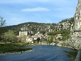 View of Vogüé and the Ardèche River | |
 Coat of arms | |
show Location of Vogüé | |
 Vogüé | |
| Coordinates: 44°33′05″N 4°24′55″E / 44.5514°N 4.4153°ECoordinates: 44°33′05″N 4°24′55″E / 44.5514°N 4.4153°E | |
| Country | France |
| Region | Auvergne-Rhône-Alpes |
| Department | Ardèche |
| Arrondissement | Largentière |
| Canton | Vallon-Pont-d'Arc |
| Intercommunality | |
| Government | |
| • Mayor (2020–2026) | Antoine Alberti |
| Area 1 | 11.72 km2 (4.53 sq mi) |
| Population (Jan. 2018)[1] | 1,086 |
| • Density | 93/km2 (240/sq mi) |
| Time zone | UTC+01:00 (CET) |
| • Summer (DST) | UTC+02:00 (CEST) |
| INSEE/Postal code | 07348 /07200 |
| Elevation | 140–342 m (459–1,122 ft) (avg. 148 m or 486 ft) |
| 1 French Land Register data, which excludes lakes, ponds, glaciers > 1 km2 (0.386 sq mi or 247 acres) and river estuaries. | |


Vogüé (French pronunciation: [vɔɡɥe]; Occitan: Vogüer) is a commune in the Ardèche department in southern France.
Geography[]
Vogüé is located along the banks of the river Ardèche.
Population[]
| Year | Pop. | ±% |
|---|---|---|
| 1962 | 549 | — |
| 1968 | 576 | +4.9% |
| 1975 | 546 | −5.2% |
| 1982 | 570 | +4.4% |
| 1990 | 631 | +10.7% |
| 1999 | 726 | +15.1% |
| 2006 | 864 | +19.0% |
| 2008 | 906 | +4.9% |
| 2011 | 940 | +3.8% |
| 2015 | 1,036 | +10.2% |
See also[]
References[]
- ^ "Populations légales 2018". INSEE. 28 December 2020.
| Wikimedia Commons has media related to Vogüé. |
| show Villages in the association Les Plus Beaux Villages de France |
|---|
| show Authority control |
|---|
This Ardèche geographical article is a stub. You can help Wikipedia by . |
Categories:
- Communes of Ardèche
- Plus Beaux Villages de France
- Ardèche geography stubs