Saint-Étienne-de-Lugdarès
show This article may be expanded with text translated from the corresponding article in French. (December 2008) Click [show] for important translation instructions. |
Saint-Étienne-de-Lugdarès | |
|---|---|
Commune | |
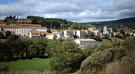 A general view of Saint-Étienne-de-Lugdarès | |
 Coat of arms | |
show Location of Saint-Étienne-de-Lugdarès | |
 Saint-Étienne-de-Lugdarès | |
| Coordinates: 44°39′09″N 3°57′23″E / 44.6525°N 3.9564°ECoordinates: 44°39′09″N 3°57′23″E / 44.6525°N 3.9564°E | |
| Country | France |
| Region | Auvergne-Rhône-Alpes |
| Department | Ardèche |
| Arrondissement | Largentière |
| Canton | Haute-Ardèche |
| Government | |
| • Mayor (2008–2014) | Marc Champel |
| Area 1 | 50.34 km2 (19.44 sq mi) |
| Population (Jan. 2018)[1] | 414 |
| • Density | 8.2/km2 (21/sq mi) |
| Time zone | UTC+01:00 (CET) |
| • Summer (DST) | UTC+02:00 (CEST) |
| INSEE/Postal code | 07232 /07590 |
| Elevation | 969–1,485 m (3,179–4,872 ft) (avg. 1,033 m or 3,389 ft) |
| 1 French Land Register data, which excludes lakes, ponds, glaciers > 1 km2 (0.386 sq mi or 247 acres) and river estuaries. | |


Saint-Étienne-de-Lugdarès (Auvergnat: Sant Estève de Ludarés) is a commune in the Ardèche department in southern France.
Population[]
| Year | Pop. | ±% |
|---|---|---|
| 1962 | 557 | — |
| 1968 | 579 | +3.9% |
| 1975 | 476 | −17.8% |
| 1982 | 422 | −11.3% |
| 1990 | 436 | +3.3% |
| 1999 | 458 | +5.0% |
| 2008 | 466 | +1.7% |
See also[]
References[]
- ^ "Populations légales 2018". INSEE. 28 December 2020.
External links[]
| Wikimedia Commons has media related to Saint-Étienne-de-Lugdarès. |
| Authority control |
|
|---|
This Ardèche geographical article is a stub. You can help Wikipedia by . |
Categories:
- Communes of Ardèche
- Ardèche geography stubs