Darbres
This article may be expanded with text translated from the corresponding article in French. (December 2008) Click [show] for important translation instructions.
|
Darbres | |
|---|---|
Commune | |
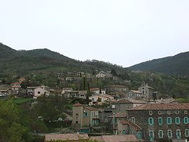 A general view of Darbres | |
Location of Darbres  | |
 Darbres | |
| Coordinates: 44°38′55″N 4°30′19″E / 44.6486°N 4.5053°ECoordinates: 44°38′55″N 4°30′19″E / 44.6486°N 4.5053°E | |
| Country | France |
| Region | Auvergne-Rhône-Alpes |
| Department | Ardèche |
| Arrondissement | Largentière |
| Canton | Berg-Helvie |
| Intercommunality | Berg et Coiron |
| Government | |
| • Mayor (2020–2026) | Patricia Eyraud[1] |
| Area 1 | 16.52 km2 (6.38 sq mi) |
| Population (Jan. 2018)[2] | 250 |
| • Density | 15/km2 (39/sq mi) |
| Time zone | UTC+01:00 (CET) |
| • Summer (DST) | UTC+02:00 (CEST) |
| INSEE/Postal code | 07077 /07170 |
| Elevation | 337–880 m (1,106–2,887 ft) (avg. 450 m or 1,480 ft) |
| 1 French Land Register data, which excludes lakes, ponds, glaciers > 1 km2 (0.386 sq mi or 247 acres) and river estuaries. | |


Darbres (French pronunciation: [daʁbʁ]) is a commune in the Ardèche department in southern France.
Population[]
| Year | Pop. | ±% |
|---|---|---|
| 1962 | 146 | — |
| 1968 | 190 | +30.1% |
| 1975 | 190 | +0.0% |
| 1982 | 168 | −11.6% |
| 1990 | 213 | +26.8% |
| 1999 | 212 | −0.5% |
| 2008 | 250 | +17.9% |
See also[]
References[]
- ^ "Répertoire national des élus: les maires". data.gouv.fr, Plateforme ouverte des données publiques françaises (in French). 9 August 2021.
- ^ "Populations légales 2018". The National Institute of Statistics and Economic Studies. 28 December 2020.
| Wikimedia Commons has media related to Darbres. |
This Ardèche geographical article is a stub. You can help Wikipedia by . |
Categories:
- Communes of Ardèche
- Ardèche geography stubs