Lagorce, Ardèche
This article may be expanded with text translated from the corresponding article in French. (December 2008) Click [show] for important translation instructions.
|
Lagorce | |
|---|---|
Commune | |
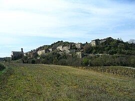 A general view of Lagorce | |
Location of Lagorce  | |
 Lagorce | |
| Coordinates: 44°26′55″N 4°25′05″E / 44.4486°N 4.4181°ECoordinates: 44°26′55″N 4°25′05″E / 44.4486°N 4.4181°E | |
| Country | France |
| Region | Auvergne-Rhône-Alpes |
| Department | Ardèche |
| Arrondissement | Largentière |
| Canton | Vallon-Pont-d'Arc |
| Government | |
| • Mayor (2020–2026) | Joëlle Rossi |
| Area 1 | 69.49 km2 (26.83 sq mi) |
| Population (Jan. 2018)[1] | 1,161 |
| • Density | 17/km2 (43/sq mi) |
| Time zone | UTC+01:00 (CET) |
| • Summer (DST) | UTC+02:00 (CEST) |
| INSEE/Postal code | 07126 /07150 |
| Elevation | 96–700 m (315–2,297 ft) (avg. 130 m or 430 ft) |
| 1 French Land Register data, which excludes lakes, ponds, glaciers > 1 km2 (0.386 sq mi or 247 acres) and river estuaries. | |


Lagorce (French pronunciation: [laɡɔʁs]; Occitan: La Gòrça) is a commune in the Ardèche department in southern France.
Geography[]
The village lies in the middle of the commune, on the right bank of the Salastre, a right tributary of the river Ibie, which flows south through the eastern part of the commune.
Population[]
| Year | Pop. | ±% |
|---|---|---|
| 1962 | 417 | — |
| 1968 | 488 | +17.0% |
| 1975 | 507 | +3.9% |
| 1982 | 602 | +18.7% |
| 1990 | 706 | +17.3% |
| 1999 | 700 | −0.8% |
| 2008 | 934 | +33.4% |
See also[]
References[]
- ^ "Populations légales 2018". The National Institute of Statistics and Economic Studies. 28 December 2020.
| Wikimedia Commons has media related to Lagorce, Ardèche. |
This Ardèche geographical article is a stub. You can help Wikipedia by . |
Categories:
- Communes of Ardèche
- Ardèche geography stubs