Beaulieu, Ardèche
show This article may be expanded with text translated from the corresponding article in French. (December 2008) Click [show] for important translation instructions. |
Beaulieu | |
|---|---|
Commune | |
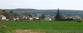 A panoramic view of Beaulieu | |
 Coat of arms | |
show Location of Beaulieu | |
 Beaulieu | |
| Coordinates: 44°21′42″N 4°14′04″E / 44.3617°N 4.2344°ECoordinates: 44°21′42″N 4°14′04″E / 44.3617°N 4.2344°E | |
| Country | France |
| Region | Auvergne-Rhône-Alpes |
| Department | Ardèche |
| Arrondissement | Largentière |
| Canton | Les Cévennes ardéchoises |
| Government | |
| • Mayor (2020–2026) | Jean-François Borie[1] |
| Area 1 | 25.47 km2 (9.83 sq mi) |
| Population (Jan. 2018)[2] | 507 |
| • Density | 20/km2 (52/sq mi) |
| Time zone | UTC+01:00 (CET) |
| • Summer (DST) | UTC+02:00 (CEST) |
| INSEE/Postal code | 07028 /07460 |
| Elevation | 108–471 m (354–1,545 ft) (avg. 129 m or 423 ft) |
| 1 French Land Register data, which excludes lakes, ponds, glaciers > 1 km2 (0.386 sq mi or 247 acres) and river estuaries. | |


Beaulieu (French pronunciation: [boljø] (![]() listen); Occitan: Bèl Luòc) is a commune in the Ardèche department in southern France.
listen); Occitan: Bèl Luòc) is a commune in the Ardèche department in southern France.
Population[]
| Year | Pop. | ±% |
|---|---|---|
| 1962 | 384 | — |
| 1968 | 418 | +8.9% |
| 1975 | 417 | −0.2% |
| 1982 | 404 | −3.1% |
| 1990 | 373 | −7.7% |
| 1999 | 400 | +7.2% |
| 2008 | 437 | +9.3% |
See also[]
References[]
- ^ "Répertoire national des élus: les maires". data.gouv.fr, Plateforme ouverte des données publiques françaises (in French). 2 December 2020.
- ^ "Populations légales 2018". INSEE. 28 December 2020.
| Wikimedia Commons has media related to Beaulieu, Ardèche. |
This Ardèche geographical article is a stub. You can help Wikipedia by . |
Categories:
- Communes of Ardèche
- Ardèche geography stubs