Ruoms
This article may be expanded with text translated from the corresponding article in French. (December 2008) Click [show] for important translation instructions.
|
Ruoms | |
|---|---|
Commune | |
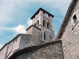 Church Saint-Pierre-aux-liens of Ruoms | |
 Coat of arms | |
Location of Ruoms  | |
 Ruoms | |
| Coordinates: 44°27′14″N 4°20′34″E / 44.4539°N 4.3428°ECoordinates: 44°27′14″N 4°20′34″E / 44.4539°N 4.3428°E | |
| Country | France |
| Region | Auvergne-Rhône-Alpes |
| Department | Ardèche |
| Arrondissement | Largentière |
| Canton | Vallon-Pont-d'Arc |
| Government | |
| • Mayor (2020–2026) | Guy Clément |
| Area 1 | 12.14 km2 (4.69 sq mi) |
| Population (Jan. 2018)[1] | 2,268 |
| • Density | 190/km2 (480/sq mi) |
| Time zone | UTC+01:00 (CET) |
| • Summer (DST) | UTC+02:00 (CEST) |
| INSEE/Postal code | 07201 /07120 |
| Elevation | 80–252 m (262–827 ft) (avg. 120 m or 390 ft) |
| 1 French Land Register data, which excludes lakes, ponds, glaciers > 1 km2 (0.386 sq mi or 247 acres) and river estuaries. | |


Ruoms (French pronunciation: [ʁɥɔ̃s]) is a commune in the Ardèche department in southern France.
Population[]
|
|
See also[]
References[]
- ^ "Populations légales 2018". The National Institute of Statistics and Economic Studies. 28 December 2020.
| Wikimedia Commons has media related to Ruoms. |
This Ardèche geographical article is a stub. You can help Wikipedia by . |
Categories:
- Communes of Ardèche
- Ardèche geography stubs