Saint-Remèze
This article may be expanded with text translated from the corresponding article in French. (December 2008) Click [show] for important translation instructions.
|
Saint-Remèze | |
|---|---|
Commune | |
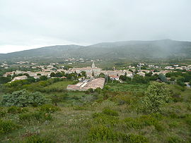 A general view of Saint-Remèze | |
 Coat of arms | |
Location of Saint-Remèze  | |
 Saint-Remèze | |
| Coordinates: 44°23′36″N 4°30′09″E / 44.3933°N 4.5025°ECoordinates: 44°23′36″N 4°30′09″E / 44.3933°N 4.5025°E | |
| Country | France |
| Region | Auvergne-Rhône-Alpes |
| Department | Ardèche |
| Arrondissement | Largentière |
| Canton | Vallon-Pont-d'Arc |
| Government | |
| • Mayor (2020–2026) | Patrick Meycelle |
| Area 1 | 42.69 km2 (16.48 sq mi) |
| Population (Jan. 2018)[1] | 863 |
| • Density | 20/km2 (52/sq mi) |
| Time zone | UTC+01:00 (CET) |
| • Summer (DST) | UTC+02:00 (CEST) |
| INSEE/Postal code | 07291 /07700 |
| Elevation | 40–663 m (131–2,175 ft) (avg. 365 m or 1,198 ft) |
| 1 French Land Register data, which excludes lakes, ponds, glaciers > 1 km2 (0.386 sq mi or 247 acres) and river estuaries. | |


Saint-Remèze (French pronunciation: [sɛ̃ ʁəmɛz]; Occitan: Sant Remèsi) is a commune in the Ardèche department in southern France.
Population[]
| Year | Pop. | ±% |
|---|---|---|
| 1962 | 429 | — |
| 1968 | 449 | +4.7% |
| 1975 | 436 | −2.9% |
| 1982 | 474 | +8.7% |
| 1990 | 454 | −4.2% |
| 1999 | 554 | +22.0% |
| 2008 | 845 | +52.5% |
See also[]
References[]
- ^ "Populations légales 2018". The National Institute of Statistics and Economic Studies. 28 December 2020.
| Wikimedia Commons has media related to Saint-Remèze. |
This Ardèche geographical article is a stub. You can help Wikipedia by . |
Categories:
- Communes of Ardèche
- Ardèche geography stubs