Mayres, Ardèche
This article may be expanded with text translated from the corresponding article in French. (December 2008) Click [show] for important translation instructions.
|
Mayres | |
|---|---|
Commune | |
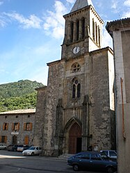 The church in Mayres | |
 Coat of arms | |
Location of Mayres  | |
 Mayres | |
| Coordinates: 44°39′59″N 4°06′54″E / 44.6664°N 4.115°ECoordinates: 44°39′59″N 4°06′54″E / 44.6664°N 4.115°E | |
| Country | France |
| Region | Auvergne-Rhône-Alpes |
| Department | Ardèche |
| Arrondissement | Largentière |
| Canton | Haute-Ardèche |
| Government | |
| • Mayor (2020–2026) | Guy Laurent[1] |
| Area 1 | 30.07 km2 (11.61 sq mi) |
| Population (Jan. 2018)[2] | 263 |
| • Density | 8.7/km2 (23/sq mi) |
| Time zone | UTC+01:00 (CET) |
| • Summer (DST) | UTC+02:00 (CEST) |
| INSEE/Postal code | 07153 /07330 |
| Elevation | 499–1,533 m (1,637–5,030 ft) (avg. 575 m or 1,886 ft) |
| 1 French Land Register data, which excludes lakes, ponds, glaciers > 1 km2 (0.386 sq mi or 247 acres) and river estuaries. | |


Mayres (French pronunciation: [mɛʁ]; Occitan: Maires) is a commune in the Ardèche department in southern France.
Population[]
| Year | Pop. | ±% |
|---|---|---|
| 1962 | 401 | — |
| 1968 | 445 | +11.0% |
| 1975 | 409 | −8.1% |
| 1982 | 366 | −10.5% |
| 1990 | 302 | −17.5% |
| 1999 | 258 | −14.6% |
| 2008 | 262 | +1.6% |
See also[]
References[]
- ^ "Répertoire national des élus: les maires". data.gouv.fr, Plateforme ouverte des données publiques françaises (in French). 9 August 2021.
- ^ "Populations légales 2018". The National Institute of Statistics and Economic Studies. 28 December 2020.
| Wikimedia Commons has media related to Mayres, Ardèche. |
This Ardèche geographical article is a stub. You can help Wikipedia by . |
Categories:
- Communes of Ardèche
- Ardèche geography stubs