Saint-Priest, Ardèche
This article may be expanded with text translated from the corresponding article in French. (December 2008) Click [show] for important translation instructions.
|
Saint-Priest | |
|---|---|
Commune | |
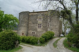 The château in Saint-Priest | |
Location of Saint-Priest  | |
 Saint-Priest | |
| Coordinates: 44°43′02″N 4°32′49″E / 44.7172°N 4.5469°ECoordinates: 44°43′02″N 4°32′49″E / 44.7172°N 4.5469°E | |
| Country | France |
| Region | Auvergne-Rhône-Alpes |
| Department | Ardèche |
| Arrondissement | Privas |
| Canton | Privas |
| Intercommunality | CA Privas Centre Ardèche |
| Government | |
| • Mayor (2020–2026) | Sandrine Chareyre |
| Area 1 | 19.15 km2 (7.39 sq mi) |
| Population (Jan. 2018)[1] | 1,240 |
| • Density | 65/km2 (170/sq mi) |
| Time zone | UTC+01:00 (CET) |
| • Summer (DST) | UTC+02:00 (CEST) |
| INSEE/Postal code | 07288 /07000 |
| Elevation | 278–1,019 m (912–3,343 ft) (avg. 420 m or 1,380 ft) |
| 1 French Land Register data, which excludes lakes, ponds, glaciers > 1 km2 (0.386 sq mi or 247 acres) and river estuaries. | |


Saint-Priest (French pronunciation: [sɛ̃ pʁi(ɛst)]) is a commune in the Ardèche department in southern France.
Population[]
| Year | Pop. | ±% |
|---|---|---|
| 1962 | 481 | — |
| 1968 | 486 | +1.0% |
| 1975 | 550 | +13.2% |
| 1982 | 749 | +36.2% |
| 1990 | 968 | +29.2% |
| 1999 | 1,107 | +14.4% |
| 2008 | 1,231 | +11.2% |
See also[]
References[]
- ^ "Populations légales 2018". The National Institute of Statistics and Economic Studies. 28 December 2020.
| Wikimedia Commons has media related to Saint-Priest (Ardèche). |
This Ardèche geographical article is a stub. You can help Wikipedia by . |
Categories:
- Communes of Ardèche
- Ardèche geography stubs