Saint-Agrève
show This article may be expanded with text translated from the corresponding article in French. (December 2008) Click [show] for important translation instructions. |
Saint-Agrève | |
|---|---|
Commune | |
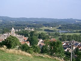 A general view of Saint-Agrève | |
 Coat of arms | |
show Location of Saint-Agrève | |
 Saint-Agrève | |
| Coordinates: 45°00′39″N 4°23′49″E / 45.0108°N 4.3969°ECoordinates: 45°00′39″N 4°23′49″E / 45.0108°N 4.3969°E | |
| Country | France |
| Region | Auvergne-Rhône-Alpes |
| Department | Ardèche |
| Arrondissement | Tournon-sur-Rhône |
| Canton | Haut-Eyrieux |
| Government | |
| • Mayor (2008–2014) | Maurice Weiss |
| Area 1 | 48.56 km2 (18.75 sq mi) |
| Population (Jan. 2018)[1] | 2,347 |
| • Density | 48/km2 (130/sq mi) |
| Time zone | UTC+01:00 (CET) |
| • Summer (DST) | UTC+02:00 (CEST) |
| INSEE/Postal code | 07204 /07320 |
| Elevation | 590–1,183 m (1,936–3,881 ft) (avg. 1,050 m or 3,440 ft) |
| 1 French Land Register data, which excludes lakes, ponds, glaciers > 1 km2 (0.386 sq mi or 247 acres) and river estuaries. | |


Saint-Agrève is a commune in the Ardèche department in southern France.
Population[]
| Year | Pop. | ±% |
|---|---|---|
| 1962 | 2,459 | — |
| 1968 | 2,484 | +1.0% |
| 1975 | 2,718 | +9.4% |
| 1982 | 2,723 | +0.2% |
| 1990 | 2,762 | +1.4% |
| 1999 | 2,688 | −2.7% |
| 2008 | 2,506 | −6.8% |
See also[]
References[]
- ^ "Populations légales 2018". INSEE. 28 December 2020.
| Wikimedia Commons has media related to Saint-Agrève. |
| Authority control |
|
|---|
This Ardèche geographical article is a stub. You can help Wikipedia by . |
Categories:
- Communes of Ardèche
- Ardèche geography stubs