Morago
| Morago New South Wales | |
|---|---|
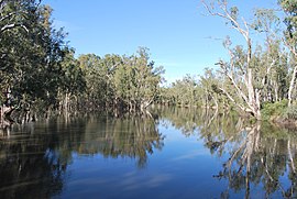 Edward River at Morago | |
 Morago | |
| Coordinates | 35°22′17″S 144°40′47″E / 35.37139°S 144.67972°ECoordinates: 35°22′17″S 144°40′47″E / 35.37139°S 144.67972°E |
| Population | 145 (2006 census)[1] |
| Postcode(s) | 2710 |
| Elevation | 79 m (259 ft) |
| Location |
|
| LGA(s) | Edward River Council |
| County | Townsend |
| State electorate(s) | Murray |
| Federal division(s) | Farrer |

Morago is a rural locality in the central part of the Riverina. It is situated by road, about 19 kilometres north west of Pretty Pine and 86 kilometres south east of Moulamein. At the 2006 census, Morago had a population of 145 people.[1]
Morago Post Office opened on 16 September 1904 and closed in 1941.[2]
Notes and references[]
- ^ a b Australian Bureau of Statistics (25 October 2007). "Morago (State Suburb)". 2006 Census QuickStats. Retrieved 31 October 2009.
- ^ Premier Postal History, Post Office List, retrieved 11 June 2009
External links[]
![]() Media related to Morago at Wikimedia Commons
Media related to Morago at Wikimedia Commons
Categories:
- Towns in New South Wales
- Towns in the Riverina
- Riverina geography stubs