Moustier-Ventadour
show This article may be expanded with text translated from the corresponding article in French. (January 2009) Click [show] for important translation instructions. |
Moustier-Ventadour | |
|---|---|
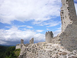 The Château de Ventadour | |
 Coat of arms | |
show Location of Moustier-Ventadour | |
 Moustier-Ventadour | |
| Coordinates: 45°23′46″N 2°06′18″E / 45.3961°N 2.105°ECoordinates: 45°23′46″N 2°06′18″E / 45.3961°N 2.105°E | |
| Country | France |
| Region | Nouvelle-Aquitaine |
| Department | Corrèze |
| Arrondissement | Ussel |
| Canton | Égletons |
| Government | |
| • Mayor (2020–2026) | Christophe Petit |
| Area 1 | 29.85 km2 (11.53 sq mi) |
| Population (Jan. 2018)[1] | 448 |
| • Density | 15/km2 (39/sq mi) |
| Time zone | UTC+01:00 (CET) |
| • Summer (DST) | UTC+02:00 (CEST) |
| INSEE/Postal code | 19145 /19300 |
| Elevation | 390–689 m (1,280–2,260 ft) (avg. 590 m or 1,940 ft) |
| 1 French Land Register data, which excludes lakes, ponds, glaciers > 1 km2 (0.386 sq mi or 247 acres) and river estuaries. | |


Moustier-Ventadour (French pronunciation: [mustje vɑ̃taduʁ]; Occitan: Mostier de Ventadorn) is a commune in the Corrèze department in central France.
Geography[]
The Luzège forms most of the commune's eastern boundary.
Population[]
| Year | Pop. | ±% |
|---|---|---|
| 1962 | 266 | — |
| 1968 | 355 | +33.5% |
| 1975 | 316 | −11.0% |
| 1982 | 302 | −4.4% |
| 1990 | 383 | +26.8% |
| 1999 | 402 | +5.0% |
| 2008 | 471 | +17.2% |
Personalities[]
- Bernart de Ventadorn, medieval troubadour
See also[]
References[]
- ^ "Populations légales 2018". INSEE. 28 December 2020.
| Wikimedia Commons has media related to Moustier-Ventadour. |
| show Authority control |
|---|
This Corrèze geographical article is a stub. You can help Wikipedia by . |
Categories:
- Communes of Corrèze
- Corrèze geography stubs