Musquash Parish, New Brunswick
Musquash | |
|---|---|
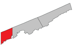 Location within Saint John County. map erroneously shows Saint John as part of Simonds Parish | |
| Coordinates: 46°10′N 66°22′W / 46.17°N 66.36°WCoordinates: 46°10′N 66°22′W / 46.17°N 66.36°W | |
| Country | |
| Province | |
| County | Saint John County |
| Erected | 1877 |
| Area | |
| • Land | 235.33 km2 (90.86 sq mi) |
| Population (2016)[1] | |
| • Total | 1,194 |
| • Density | 5.1/km2 (13/sq mi) |
| • Change 2011-2016 | |
| • Dwellings | 600 |
| Time zone | UTC-4 (AST) |
| • Summer (DST) | UTC-3 (ADT) |
| Median Income* | $71,680 CDN |
| |

Musquash is a civil parish in Saint John County, New Brunswick, Canada.[2]
For governance purposes it forms the local service district of the parish of Musquash,[3] which is a member of the Fundy Regional Service Commission (FRSC).[4]
Origin of name[]
The Provincial Archives of New Brunswick gives it origin as "derived from the Maliseet word for muskrat" but does not mention that word or give a source.[5]
William F. Ganong has entries for Musquash Islands and Musquash Harbour, the former translated from the French I. aux Rats musquez, island of muskrats, the latter uncertain, both possibly related to Maliseet words.[6]
Musquash is a synonym of muskrat, possibly borrowed from Massachusett.[7]
History[]
Musquash was erected in 1877 from Lancaster Parish.[8]
Boundaries[]
Musquash Parish is bounded:[2][9][10]
- on the north by the Kings County line;
- on the east by the City of Saint John;
- on the south by the Bay of Fundy;
- on the west by the Charlotte County line.
Communities[]
Communities at least partly within the parish.[9][10][11]
- Chance Harbour
- Dipper Harbour East
- Dipper Harbour West
- Five Fathom Hole
- Gooseberry Cove
- Little Lepreau
- Musquash
- Prince of Wales
- South Musquash
Bodies of water[]
Bodies of water[a] at least partly within the parish.[9][10][11]
- Little Lepreau River
- West Branch Musquash River
- Belvidere Stream
- Deer Lake Stream
- Fishing Stream
- Hanson Stream
- Menzies Stream
- Dipper Harbour Creek
- Ferguson Creek
- Goose Creek
- McLaughlin Creek
- Moose Creek
- Wetmore Creek
- West Branch Reservoir
- Back Channel
- The Narrows
- Bay of Fundy
- Plumper Hole
- Maces Bay
- Chance Harbour
- Dipper Harbour
- Little Dipper Harbour
- Musquash Harbour
- Hepburn Basin
- Bonny Doone Lake
- more than twenty other officially named lakes
Islands[]
Islands at least partly within the parish.[9][10][11]
- Gooseberry Island
- Musquash Island
- Stillwater Island
- Man Rock
- Musquash Ledges
- Pork Ledge
Other notable places[]
Parks, historic sites, and other noteworthy places at least partly within the parish.[9][10][11][12]
- Dipper Harbour Back Cove Protected Natural Area
- Gooseberry Cove Protected Natural Area
- Loch Alva Protected Natural Area
- Log Falls Dam
- Musquash Estuary Protected Natural Area
- Point Lepreau
- Round Meadow Cove Protected Natural Area
Demographics[]
Population[]
|
Language[]Mother tongue (2016)[1]
|
Access Routes[]
Highways and numbered routes that run through the parish, including external routes that start or finish at the parish limits:[15]
|
|
|
See also[]
Notes[]
- ^ Not including brooks, ponds or coves.
References[]
- ^ a b c d "Census Profile, 2016 Census: Musquash, Parish [Census subdivision], New Brunswick". Statistics Canada. Retrieved September 29, 2019.
- ^ a b "Chapter T-3 Territorial Division Act". Government of New Brunswick. Retrieved 13 November 2020.
- ^ "New Brunswick Regulation 84-168 under the Municipalities Act (O.C. 84-582)". Government of New Brunswick. Retrieved 22 July 2020.
- ^ "Communities in each of the 12 Regional Service Commissions (RSC) / Les communautés dans chacune des 12 Commissions de services régionaux (CSR)" (PDF), Government of New Brunswick, July 2017, retrieved 2 February 2021
- ^ "Musquash Parish". Provincial Archives of New Brunswick. Retrieved 23 October 2020.
- ^ Ganong, William F. (1896). A Monograph of the Place-Nomenclature of the Province of New Brunswick. Royal Society of Canada. p. 227. Retrieved 17 March 2021.
- ^ "musquash". The Free Dictionary. Farlex. Retrieved 23 October 2020. American Heritage Dictionary of the English Language and Collins English Dictionary are cited.
- ^ "40 Vic. c. 21 An Act to erect part of the Parish of Lancaster, in the City and County of Saint John, into a separate Parish.". Acts of the General Assembly of Her Majesty's Province of New Brunswick. Passed in the Month of March 1877. Fredericton: Government of New Brunswick. 1877. pp. 91–93. Available as a free ebook from Google Books.
- ^ a b c d e "No. 163". Provincial Archives of New Brunswick. Department of Natural Resources and Energy Development. Retrieved 22 June 2021. Remainder of parish on map 164 at same site.
- ^ a b c d e "482" (PDF). Transportation and Infrastructure. Government of New Brunswick. Retrieved 22 June 2021. Remainder of parish on mapbooks 483, 492, 493, and 499 at same site.
- ^ a b c d "Search the Canadian Geographical Names Database (CGNDB)". Government of Canada. Retrieved 2 July 2021.
- ^ "Explore New Brunswick's Protected Natural Areas". GeoNB. Retrieved 2 July 2021.
- ^ Statistics Canada: 2001, 2006 census
- ^ 2011 Statistics Canada Census Profile: Musquash Parish, New Brunswick
- ^ Atlantic Canada Back Road Atlas ISBN 978-1-55368-618-7
Places adjacent to Musquash Parish, New Brunswick | ||||||||||||||||
|---|---|---|---|---|---|---|---|---|---|---|---|---|---|---|---|---|
| ||||||||||||||||
| Subdivisions |
|
|---|---|
| Cities | |
| Counties | |
| |
- Parishes of Saint John County, New Brunswick
- Local service districts of Saint John County, New Brunswick