National Register of Historic Places listings in Brunswick County, North Carolina
This list includes properties and districts listed on the National Register of Historic Places in Brunswick County, North Carolina. Click the "Map of all coordinates" link to the right to view an online map of all properties and districts with latitude and longitude coordinates in the table below.[1]
Current listings[]
- This National Park Service list is complete through NPS recent listings posted February 11, 2022.[2]
| [3] | Name on the Register[4] | Image | Date listed[5] | Location | City or town | Description |
|---|---|---|---|---|---|---|
| 1 | Bald Head Creek Boathouse |  |
December 1, 1997 (#97001496) |
Smith's Island at the mouth of the Cape Fear River 33°51′41″N 77°59′11″W / 33.861389°N 77.986389°W | Smith's Island | |
| 2 | Bald Head Island Lighthouse |  |
April 28, 1975 (#75001242) |
South of Southport on Smith's Island at Bald Head 33°52′24″N 78°00′03″W / 33.873333°N 78.000833°W | Southport | Known as "Old Baldy"; oldest lighthouse in North Carolina[6] |
| 3 | Brunswick County Courthouse | 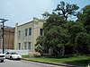 |
May 10, 1979 (#79001663) |
Davis and Moore Sts. 33°55′08″N 78°01′05″W / 33.918889°N 78.018056°W | Southport | |
| 4 | Brunswick Town Historic District | 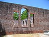 |
September 6, 1978 (#78001932) |
North of Southport off North Carolina Highway 133 34°02′27″N 77°56′41″W / 34.040833°N 77.944722°W | Southport | |
| 5 | Cape Fear Civil War Shipwreck Discontiguous District | December 23, 1985 (#85003195) |
Address Restricted | Holden Beach | ||
| 6 | Cape Fear Lighthouse Complex |  |
August 29, 1978 (#78001931) |
South of Kure Beach 33°50′41″N 77°58′02″W / 33.844722°N 77.967222°W | Kure Beach | |
| 7 | Fort Caswell Historic District |  |
December 31, 2013 (#13001025) |
100 Caswell Beach Rd. 33°53′28″N 78°01′41″W / 33.8911753°N 78.0280691°W | Caswell Beach | |
| 8 | Fort Johnston |  |
June 7, 1974 (#74001327) |
Moore St. 33°55′05″N 78°01′03″W / 33.918169°N 78.017511°W | Southport | |
| 9 | Oak Island Life Saving Station |  |
December 28, 2000 (#00001553) |
217 Caswell Beach Rd. 33°53′29″N 78°02′01″W / 33.891389°N 78.033611°W | Caswell Beach | |
| 10 | Oak Island Lighthouse | 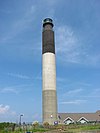 |
April 5, 2007 (#07000293) |
300A Caswell Beach Rd., north of North Carolina Highway 133 33°53′33″N 78°02′07″W / 33.8925°N 78.035278°W | Caswell Beach | |
| 11 | New Hope Presbyterian Church |  |
December 7, 2011 (#11000888) |
800 Cherrytree Rd., NE. 34°08′09″N 78°07′09″W / 34.135833°N 78.119133°W | Winnabow | |
| 12 | Orton Plantation |  |
April 11, 1973 (#73001294) |
On the Cape Fear River at the junction of NC 1530 and 1529; also 9149 Orton Rd. 34°03′31″N 77°56′44″W / 34.058611°N 77.945556°W | Smithville Township | Second set of boundaries represents a boundary increase of September 20, 2013 |
| 13 | Southport Historic District |  |
November 25, 1980 (#80002801) |
Roughly bounded by the Cape Fear River and Rhett, Bay, Short and Brown Sts. 33°55′09″N 78°01′13″W / 33.919242°N 78.020325°W | Southport | |
| 14 | St. Philip's Church, Brunswick Town | |
February 26, 1970 (#70000442) |
South of Orton off SR 1533 34°02′32″N 77°56′55″W / 34.042222°N 77.948611°W | Brunswick Town | |
| 15 | August 9, 2021 (#100006808) |
225 East Leonard St. 33°55′29″N 78°01′06″W / 33.9248°N 78.0182°W | Southport | |||
| 16 | T. B. McClintic | June 3, 1994 (#94000532) |
Tripp's Marina 33°54′53″N 78°22′33″W / 33.9147°N 78.3758°W |

See also[]
| Wikimedia Commons has media related to National Register of Historic Places in Brunswick County, North Carolina. |
- National Register of Historic Places listings in North Carolina
- List of National Historic Landmarks in North Carolina
References[]
- ^ The latitude and longitude information provided in this table was derived originally from the National Register Information System, which has been found to be fairly accurate for about 99% of listings. Some locations in this table may have been corrected to current GPS standards.
- ^ National Park Service, United States Department of the Interior, "National Register of Historic Places: Weekly List Actions", retrieved February 11, 2022.
- ^ Numbers represent an alphabetical ordering by significant words. Various colorings, defined here, differentiate National Historic Landmarks and historic districts from other NRHP buildings, structures, sites or objects.
- ^ "National Register Information System". National Register of Historic Places. National Park Service. April 24, 2008.
- ^ The eight-digit number below each date is the number assigned to each location in the National Register Information System database, which can be viewed by clicking the number.
- ^ Seldon, Lynn (20 July 2008). "Take a shine to N.C. lighthouse cottages". Atlanta Journal-Constitution. Retrieved 5 July 2009.

U.S. National Register of Historic Places | |
|---|---|
| Topics |
|
| Lists by state |
|
| Lists by insular areas | |
| Lists by associated state | |
| Other areas | |
| Related | |
| |
Municipalities and communities of Brunswick County, North Carolina, United States | ||
|---|---|---|
County seat: Bolivia | ||
| Cities |
|  |
| Towns |
| |
| Village | ||
| Townships | ||
| Unincorporated communities | ||
| ||
Categories:
- Brunswick County, North Carolina
- Lists of National Register of Historic Places in North Carolina by county
- National Register of Historic Places in Brunswick County, North Carolina