From Wikipedia, the free encyclopedia
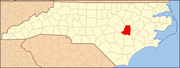
This list includes properties and districts listed on the National Register of Historic Places in Wayne County, North Carolina . Click the "Map of all coordinates" link to the right to view a Google map of all properties and districts with latitude and longitude coordinates in the table below.[1]
Current listings [ ] This National Park Service list is complete through NPS recent listings posted February 11, 2022. [2]
[3] Name on the Register[4]
Image
Date listed[5]
Location
City or town
Description
1
Charles B. Aycock Birthplace Upload image February 26, 1970 (#70000482 ) 6 miles from jct. of SR 1542 and U.S. 117 35°31′11″N 77°58′30″W / 35.519722°N 77.975°W / 35.519722; -77.975 (Charles B. Aycock Birthplace ) Fremont
2
Barnes-Hooks Farm Upload image September 1, 1995 (#95001072 ) 414 Stuckey Rd. 35°34′15″N 77°59′05″W / 35.570833°N 77.984722°W / 35.570833; -77.984722 (Barnes-Hooks Farm ) Fremont
3
Borden Manufacturing Company
February 2, 2005 (#04001583 ) 800 and 801 N. William St. 35°23′32″N 77°59′20″W / 35.392222°N 77.988889°W / 35.392222; -77.988889 (Borden Manufacturing Company ) Goldsboro
4
Eureka United Methodist Church Upload image August 26, 1982 (#82003520 ) Church St. 35°32′40″N 77°52′47″W / 35.544444°N 77.879722°W / 35.544444; -77.879722 (Eureka United Methodist Church ) Eureka
5
First Presbyterian Church
May 29, 1979 (#79003340 ) 111 W. Ash St. 35°23′10″N 77°59′50″W / 35.386111°N 77.997222°W / 35.386111; -77.997222 (First Presbyterian Church ) Goldsboro
6
Former U.S. Post Office Upload image June 2, 1995 (#95000670 ) 124 W. James St. 35°11′50″N 78°04′01″W / 35.197222°N 78.066944°W / 35.197222; -78.066944 (Former U.S. Post Office ) Mount Olive
7
L. D. Giddens and Son Jewelry Store
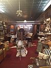
March 19, 1979 (#79001763 ) 135 S. Center St. 35°22′56″N 77°59′52″W / 35.382325°N 77.997733°W / 35.382325; -77.997733 (L. D. Giddens and Son Jewelry Store ) Goldsboro
8
Goldsboro Union Station
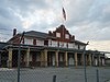
April 13, 1977 (#77001015 ) 101 North Carolina St. 35°23′05″N 78°00′15″W / 35.384722°N 78.004167°W / 35.384722; -78.004167 (Goldsboro Union Station ) Goldsboro
9
Harry Fitzhugh Lee House Upload image March 1, 1984 (#84002542 ) 310 W. Walnut St. 35°23′03″N 78°00′11″W / 35.384167°N 78.003056°W / 35.384167; -78.003056 (Harry Fitzhugh Lee House ) Goldsboro
10
Mount Olive High School Upload image October 22, 1998 (#98001266 ) 100 Wooten St. 35°12′01″N 78°04′23″W / 35.200278°N 78.073056°W / 35.200278; -78.073056 (Mount Olive High School ) Mount Olive
11
Mount Olive Historic District Upload image May 27, 1999 (#99000639 ) Roughly bounded by Park Ave., Wooten, Nelson, and Johnson Sts. 35°11′42″N 78°04′09″W / 35.195°N 78.069167°W / 35.195; -78.069167 (Mount Olive Historic District ) Mount Olive
12
Odd Fellows Lodge
August 3, 1978 (#78001984 ) 111-115 N. John St. 35°23′00″N 77°59′43″W / 35.383261°N 77.995386°W / 35.383261; -77.995386 (Odd Fellows Lodge ) Goldsboro
13
Perry-Cherry House Upload image March 13, 1986 (#86000392 ) 308 W. Main St. 35°11′50″N 78°04′14″W / 35.197222°N 78.070556°W / 35.197222; -78.070556 (Perry-Cherry House ) Mount Olive
14
Southerland-Burnette House Upload image February 8, 1988 (#88000057 ) 201 N. Chesnut St. 35°11′51″N 78°04′04″W / 35.1975°N 78.067778°W / 35.1975; -78.067778 (Southerland-Burnette House ) Mount Olive
15
Vernon Upload image October 9, 1974 (#74001387 ) Address Restricted Mount Olive Demolished[6]
16
Solomon and Henry Weil Houses
December 22, 1976 (#76001350 ) 204 and 200 W. Chestnut St. 35°22′56″N 78°00′00″W / 35.382169°N 78.000067°W / 35.382169; -78.000067 (Solomon and Henry Weil Houses ) Goldsboro
17
Dred and Ellen Yelverton House Upload image August 27, 2009 (#09000662 ) 1979 NC 222 E. 35°33′36″N 78°00′28″W / 35.559897°N 78.0078°W / 35.559897; -78.0078 (Dred and Ellen Yelverton House ) Fremont
See also [ ] References [ ]
^ The latitude and longitude information provided in this table was derived originally from the National Register Information System, which has been found to be fairly accurate for about 99% of listings. Some locations in this table may have been corrected to current GPS standards.
^ National Park Service, United States Department of the Interior , "National Register of Historic Places: Weekly List Actions" , retrieved February 11, 2022.
^ Numbers represent an alphabetical ordering by significant words. Various colorings, defined here , differentiate National Historic Landmarks and historic districts from other NRHP buildings, structures, sites or objects.
^ "National Register Information System" . National Register of Historic Places National Park Service . April 24, 2008.^ The eight-digit number below each date is the number assigned to each location in the National Register Information System database, which can be viewed by clicking the number.
^ "North Carolina Listings in the National Register of Historic Places by County" . North Carolina State Historic Preservation Office. 22 October 2008. Archived from the original on 30 November 2012. Retrieved 6 July 2009 .
Topics Lists Other lists
U.S. National Register of Historic Places
Topics Lists by state Lists by insular areas Lists by associated state Other areas Related
National Register of Historic Places portal Category
Municipalities and communities of Wayne County, North Carolina United States
County seat Goldsboro
City Towns Village CDPs Other Footnotes ‡This populated place also has portions in an adjacent county or counties
North Carolina portal United States portal
Categories :
Wayne County, North Carolina Lists of National Register of Historic Places in North Carolina by county National Register of Historic Places in Wayne County, North Carolina Hidden categories:
Articles using NRISref without a reference number Lists of coordinates Geographic coordinate lists Articles with Geo Commons category link is on Wikidata