From Wikipedia, the free encyclopedia
This list includes properties and districts listed on the National Register of Historic Places in Perquimans County, North Carolina . Click the "Map of all coordinates" link to the right to view a Google map of all properties and districts with latitude and longitude coordinates in the table below.[1]
Current listings [ ] This National Park Service list is complete through NPS recent listings posted February 11, 2022. [2]
[3] Name on the Register
Image
Date listed[4]
Location
City or town
Description
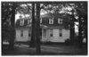
1
Belvidere
August 2, 1977 (#77001008 ) NC 37, W of Perquimans River 36°16′08″N 76°32′48″W / 36.268889°N 76.546667°W / 36.268889; -76.546667 (Belvidere ) Belvidere
2
Belvidere Historic District Upload image June 4, 1999 (#99000600 ) Roughly bounded by the Perquinmans R., NC 37, NC 1200, and NC 1213 36°16′08″N 76°32′17″W / 36.268889°N 76.538056°W / 36.268889; -76.538056 (Belvidere Historic District ) Belvidere
3
Church of the Holy Trinity
June 11, 1998 (#98000688 ) 207 S. Church St. 36°11′14″N 76°28′00″W / 36.187222°N 76.466667°W / 36.187222; -76.466667 (Church of the Holy Trinity ) Hertford
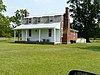
4
Cove Grove
August 7, 1974 (#74001366 ) E of Hertford near SR 1301 and 1302 36°11′02″N 76°25′02″W / 36.183889°N 76.417222°W / 36.183889; -76.417222 (Cove Grove ) Hertford
5
Fletcher-Skinner-Nixon House and Outbuildings
January 21, 1994 (#93001541 ) NC 1301 NE side, 0.45 miles SE of jct. with NC 1300 36°11′45″N 76°25′45″W / 36.195833°N 76.429167°W / 36.195833; -76.429167 (Fletcher-Skinner-Nixon House and Outbuildings ) Hertford
6
Hertford Historic District
October 22, 1998 (#98001264 ) Roughly bounded by the Perquimans River and W. Academy St., Hyde St., and Dobbs St. 36°11′23″N 76°28′04″W / 36.189722°N 76.467778°W / 36.189722; -76.467778 (Hertford Historic District ) Hertford
7
Jonathan Hill Jacocks House Upload image April 1, 1998 (#98000276 ) Jct. of New Hope Rd. and Jacocks Ln. 36°08′47″N 76°15′59″W / 36.146389°N 76.266389°W / 36.146389; -76.266389 (Jonathan Hill Jacocks House )
8
Land's End
September 20, 1973 (#73001365 ) SE of Hertford near jct. of SR 1300 and 1324 36°06′40″N 76°13′17″W / 36.111111°N 76.221389°W / 36.111111; -76.221389 (Land's End ) Hertford Home of Col. James Leigh (1781-1854)
9
Mitchell-Ward House
June 25, 1999 (#99000716 ) Jct. NC 1119 and NC 1002 36°16′30″N 76°34′05″W / 36.275°N 76.568056°W / 36.275; -76.568056 (Mitchell-Ward House ) Belvidere
10
Myers-White House
January 20, 1972 (#72000986 ) NE of Bethel on SR 1347 36°07′12″N 76°26′58″W / 36.120094°N 76.449486°W / 36.120094; -76.449486 (Myers-White House )
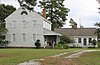
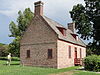
11
Newbold-White House
June 24, 1971 (#71000615 ) SE of Hertford off SR 1336 36°10′00″N 76°26′15″W / 36.166667°N 76.4375°W / 36.166667; -76.4375 (Newbold-White House ) Hertford
12
Samuel Nixon House Upload image October 15, 1973 (#73001366 ) NW of Hertford on SR 1121 36°13′03″N 76°29′45″W / 36.2175°N 76.495833°W / 36.2175; -76.495833 (Samuel Nixon House ) Hertford
13
Old Neck Historic District Upload image September 6, 1996 (#96000929 ) Roughly bounded by US 17, NC 1302, NC 1300, Suttons Cr., and the Perquimans River 36°11′33″N 76°25′07″W / 36.1925°N 76.418611°W / 36.1925; -76.418611 (Old Neck Historic District ) Hertford
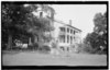
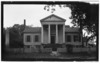
14
Perquimans County Courthouse
May 10, 1979 (#79001743 ) Church St. 36°11′21″N 76°27′55″W / 36.189167°N 76.465278°W / 36.189167; -76.465278 (Perquimans County Courthouse ) Hertford
15
Stockton
June 7, 1974 (#74001368 ) S of Woodville 36°12′57″N 76°19′06″W / 36.215833°N 76.318333°W / 36.215833; -76.318333 (Stockton ) Woodville
16
Sutton-Newby House
September 10, 1974 (#74001367 ) E of Hertford 36°11′16″N 76°22′56″W / 36.187778°N 76.382222°W / 36.187778; -76.382222 (Sutton-Newby House ) Hertford
17
Isaac White House
March 23, 1979 (#79001742 ) NE of Bethel on SR 1339 36°07′38″N 76°27′39″W / 36.127281°N 76.460828°W / 36.127281; -76.460828 (Isaac White House )
18
Winfall Historic District Upload image January 15, 2003 (#02001715 ) Roughly along Main St. and Wiggins Rd. 36°13′11″N 76°27′43″W / 36.219722°N 76.461944°W / 36.219722; -76.461944 (Winfall Historic District ) Winfall
See also [ ] References [ ]
^ The latitude and longitude information provided in this table was derived originally from the National Register Information System, which has been found to be fairly accurate for about 99% of listings. Some locations in this table may have been corrected to current GPS standards.
^ National Park Service, United States Department of the Interior , "National Register of Historic Places: Weekly List Actions" , retrieved February 11, 2022.
^ Numbers represent an alphabetical ordering by significant words. Various colorings, defined here , differentiate National Historic Landmarks and historic districts from other NRHP buildings, structures, sites or objects.
^ The eight-digit number below each date is the number assigned to each location in the National Register Information System database, which can be viewed by clicking the number.
Topics Lists Other lists
U.S. National Register of Historic Places
Topics Lists by state Lists by insular areas Lists by associated state Other areas Related
National Register of Historic Places portal Category
Towns Unincorporated
North Carolina portal United States portal
Categories :
Perquimans County, North Carolina Lists of National Register of Historic Places in North Carolina by county Buildings and structures in Perquimans County, North Carolina National Register of Historic Places in Perquimans County, North Carolina Hidden categories:
Lists of coordinates Geographic coordinate lists Articles with Geo Commons category link is on Wikidata