National Register of Historic Places listings in Tyrrell County, North Carolina

This list includes properties and districts listed on the National Register of Historic Places in Tyrrell County, North Carolina. Click the "Map of all coordinates" link to the right to view a Google map of all properties and districts with latitude and longitude coordinates in the table below.[1]
Current listings[]
- This National Park Service list is complete through NPS recent listings posted February 11, 2022.[2]
| [3] | Name on the Register | Image | Date listed[4] | Location | City or town | Description |
|---|---|---|---|---|---|---|
| 1 | Columbia Historic District | 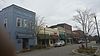 |
March 17, 1994 (#94000219) |
Roughly bounded by the Scuppernong River, U.S. Route 64, Road St., and Howard St. 35°55′05″N 76°15′08″W / 35.918056°N 76.252222°W | Columbia | |
| 2 | Scuppernong River Bridge | 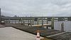 |
March 5, 1992 (#92000078) |
U.S. Route 64 Business across the Scuppernong River 35°55′02″N 76°15′19″W / 35.917222°N 76.255278°W | Columbia | Since demolished, part of western approach still extant |
| 3 | Tyrrell County Courthouse |  |
May 10, 1979 (#79001756) |
Main and Broad Sts. 35°55′03″N 76°15′07″W / 35.917617°N 76.251903°W | Columbia |

See also[]
| Wikimedia Commons has media related to National Register of Historic Places in Tyrrell County, North Carolina. |
- National Register of Historic Places listings in North Carolina
- List of National Historic Landmarks in North Carolina
References[]
- ^ The latitude and longitude information provided in this table was derived originally from the National Register Information System, which has been found to be fairly accurate for about 99% of listings. Some locations in this table may have been corrected to current GPS standards.
- ^ National Park Service, United States Department of the Interior, "National Register of Historic Places: Weekly List Actions", retrieved February 11, 2022.
- ^ Numbers represent an alphabetical ordering by significant words. Various colorings, defined here, differentiate National Historic Landmarks and historic districts from other NRHP buildings, structures, sites or objects.
- ^ The eight-digit number below each date is the number assigned to each location in the National Register Information System database, which can be viewed by clicking the number.

| Topics | |
|---|---|
| Lists by state |
|
| Lists by insular areas | |
| Lists by associated state | |
| Other areas | |
| Related | |
| |
Municipalities and communities of Tyrrell County, North Carolina, United States | ||
|---|---|---|
| Town |  | |
| Unincorporated communities | ||
| ||
Categories:
- Tyrrell County, North Carolina
- Lists of National Register of Historic Places in North Carolina by county
- National Register of Historic Places in Tyrrell County, North Carolina