[3] Name on the Register[4]
Image
Date listed[5]
Location
City or town
Description
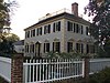
1
Attmore-Oliver House
January 20, 1972 (#72000932 ) 513 Broad St. 35°06′30″N 77°02′31″W / 35.108333°N 77.041944°W / 35.108333; -77.041944 (Attmore-Oliver House ) New Bern
2
J.T. Barber School
December 20, 2006 (#06001139 ) 1700 Cobb St. 35°07′04″N 77°03′54″W / 35.117778°N 77.065°W / 35.117778; -77.065 (J.T. Barber School ) New Bern
3
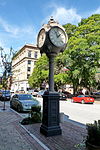
Baxter Clock
July 2, 1973 (#73001319 ) 323 Pollock St. 35°06′23″N 77°02′22″W / 35.106389°N 77.039444°W / 35.106389; -77.039444 (Baxter Clock ) New Bern
4
Bellair
August 25, 1972 (#72000933 ) West of New Bern off SR 1401 35°10′50″N 77°07′19″W / 35.180556°N 77.121944°W / 35.180556; -77.121944 (Bellair ) New Bern
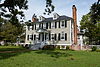
5
Blades House
January 14, 1972 (#72000934 ) 602 Middle St. 35°06′40″N 77°02′21″W / 35.111111°N 77.039167°W / 35.111111; -77.039167 (Blades House ) New Bern
6
Bryan House and Office
March 24, 1972 (#72000935 ) 603-605 Pollock St. 35°06′24″N 77°02′38″W / 35.106667°N 77.043889°W / 35.106667; -77.043889 (Bryan House and Office ) New Bern
7
Cedar Grove Cemetery
December 5, 1972 (#72000936 ) Bounded by Queen, George, Cypress, Howard, and Metcalf Sts. 35°06′53″N 77°02′41″W / 35.114722°N 77.044722°W / 35.114722; -77.044722 (Cedar Grove Cemetery ) New Bern
8
Cedar Street Recreation Center
August 21, 2003 (#03000802 ) 822 Cedar St. 35°06′44″N 77°02′47″W / 35.112222°N 77.046389°W / 35.112222; -77.046389 (Cedar Street Recreation Center ) New Bern
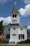
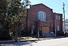
9
Centenary Methodist Church
September 11, 1972 (#72000937 ) 209 New St. 35°06′33″N 77°02′21″W / 35.109167°N 77.039167°W / 35.109167; -77.039167 (Centenary Methodist Church ) New Bern
10
Central Elementary School
January 20, 1972 (#72000938 ) 311-313 New St. and 517 Hancock St. 35°06′37″N 77°02′29″W / 35.110278°N 77.041389°W / 35.110278; -77.041389 (Central Elementary School ) New Bern
11
Christ Episcopal Church and Parish House
April 13, 1973 (#73001320 ) 320 Pollock St. 35°06′26″N 77°02′21″W / 35.107222°N 77.039167°W / 35.107222; -77.039167 (Christ Episcopal Church and Parish House ) New Bern
12
Clear Springs Plantation Upload image March 14, 1973 (#73001318 ) N of Jasper 35°12′57″N 77°12′03″W / 35.215833°N 77.200833°W / 35.215833; -77.200833 (Clear Springs Plantation )
13
Coor-Bishop House
November 9, 1972 (#72000939 ) 501 E. Front St. 35°06′33″N 77°02′10″W / 35.109167°N 77.036111°W / 35.109167; -77.036111 (Coor-Bishop House ) New Bern
14
Coor-Gaston House
February 1, 1972 (#72000940 ) 421 Craven St. 35°06′32″N 77°02′18″W / 35.108889°N 77.038333°W / 35.108889; -77.038333 (Coor-Gaston House ) New Bern
15
Craven Terrace Upload image August 19, 2014 (#14000517 ) 601 Roundtree St. 35°06′34″N 77°02′57″W / 35.1095°N 77.0493°W / 35.1095; -77.0493 (Craven Terrace ) New Bern
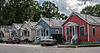
16
DeGraffenried Park Historic District
August 9, 2006 (#06000689 ) Roughly bounded by Neuse Boulevard, Fort Totten Dr., Trent Rd., and Chattawka Ln. 35°06′27″N 77°03′38″W / 35.1075°N 77.060556°W / 35.1075; -77.060556 (DeGraffenried Park Historic District ) New Bern
17
Ebenezer Presbyterian Church
June 30, 1997 (#97000573 ) 720 Bern St. 35°06′42″N 77°02′46″W / 35.111667°N 77.046111°W / 35.111667; -77.046111 (Ebenezer Presbyterian Church ) New Bern
18
First Baptist Church
March 24, 1972 (#72000941 ) Middle St. and Church Alley 35°06′23″N 77°02′25″W / 35.106389°N 77.040278°W / 35.106389; -77.040278 (First Baptist Church ) New Bern
19
First Church of Christ, Scientist
October 2, 1973 (#73001321 ) 406 and 408 Middle St. 35°06′31″N 77°02′22″W / 35.108611°N 77.039444°W / 35.108611; -77.039444 (First Church of Christ, Scientist ) New Bern
20
First Missionary Baptist Church
June 30, 1997 (#97000574 ) 819 Cypress St. 35°06′51″N 77°02′51″W / 35.114167°N 77.0475°W / 35.114167; -77.0475 (First Missionary Baptist Church ) New Bern
21
First Presbyterian Church and Churchyard
February 1, 1972 (#72000942 ) New St. between Middle and Hancock Sts. 35°06′36″N 77°02′25″W / 35.110000°N 77.040278°W / 35.110000; -77.040278 (First Presbyterian Church and Churchyard ) New Bern
22
Ghent Historic District
March 17, 1988 (#88000226 ) Roughly bounded by Trent Blvd., First St., Park Ave., and Seventh St. 35°06′18″N 77°03′45″W / 35.105°N 77.0625°W / 35.105; -77.0625 (Ghent Historic District ) New Bern
23
Gull Harbor
August 14, 1973 (#73001322 ) 514 E. Front St. 35°06′37″N 77°02′08″W / 35.110278°N 77.035556°W / 35.110278; -77.035556 (Gull Harbor ) New Bern
24
Harvey Mansion
November 12, 1971 (#71000574 ) 219 Tryon Palace Dr. 35°06′16″N 77°02′17″W / 35.104444°N 77.038056°W / 35.104444; -77.038056 (Harvey Mansion ) New Bern
25
Hawks House
March 16, 1972 (#72000943 ) 306 Hancock St. 35°06′27″N 77°02′29″W / 35.1075°N 77.041389°W / 35.1075; -77.041389 (Hawks House ) New Bern According to a contact at the New Bern Historical Society, this house was moved in the 1970s to 517 New Street. The property at 306 Hancock St. is vacant.
26
William Hollister House
June 30, 1972 (#72000944 ) 613 Broad St. 35°06′33″N 77°02′40″W / 35.109167°N 77.044444°W / 35.109167; -77.044444 (William Hollister House ) New Bern
27
Thomas Jerkins House
October 18, 1972 (#72000945 ) 305 Johnson St. 35°06′38″N 77°02′17″W / 35.110556°N 77.038056°W / 35.110556; -77.038056 (Thomas Jerkins House ) New Bern
28
Jerkins-Duffy House
March 17, 1988 (#88000232 ) 301 Johnston St. 35°06′37″N 77°02′18″W / 35.110278°N 77.038333°W / 35.110278; -77.038333 (Jerkins-Duffy House ) New Bern
29
Jones-Jarvis House
April 11, 1973 (#73001323 ) 528 E. Front St. 35°06′40″N 77°02′11″W / 35.111111°N 77.036389°W / 35.111111; -77.036389 (Jones-Jarvis House ) New Bern
30
Ulysses S. Mace House
June 4, 1973 (#73001324 ) 518 Broad St. 35°06′31″N 77°02′34″W / 35.108611°N 77.042778°W / 35.108611; -77.042778 (Ulysses S. Mace House ) New Bern
31
Masonic Temple and Theater
March 16, 1972 (#72000946 ) 516 Hancock St. 35°06′39″N 77°02′26″W / 35.110833°N 77.040556°W / 35.110833; -77.040556 (Masonic Temple and Theater ) New Bern
32
Mount Shiloh Missionary Baptist Church
March 1, 2007 (#07000093 ) 307 Scott St. 35°04′48″N 77°02′18″W / 35.08°N 77.038333°W / 35.08; -77.038333 (Mount Shiloh Missionary Baptist Church ) New Bern
33
New Bern Battlefield Site
October 19, 2001 (#01001129 ) US 70 E., approx. 4.5 miles SE of New Bern 35°02′39″N 77°00′56″W / 35.044167°N 77.015556°W / 35.044167; -77.015556 (New Bern Battlefield Site ) New Bern
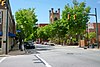
34
New Bern Historic District
June 19, 1973 (#73001325 ) Roughly bounded by Neuse and Trent Rivers and Queen St.; also roughly 2 blocks of N. Craven, 1 block of Pasteur St., and roughly along Bern, West, and Cedar Sts. and Trent Court; also bounded by Roundtree, Oak, W. F, W. A, N. Bern, Bern, Nunn & Cedar Sts. 35°06′56″N 77°02′58″W / 35.115556°N 77.049444°W / 35.115556; -77.049444 (New Bern Historic District ) New Bern Second and third sets of boundaries represents boundary increases of September 25, 2003 and January 5, 2016 .
35
New Bern Municipal Building
June 4, 1973 (#73001326 ) Pollock and Craven Sts. 35°06′25″N 77°02′18″W / 35.106944°N 77.038472°W / 35.106944; -77.038472 (New Bern Municipal Building ) New Bern
36
New Bern National Cemetery
January 31, 1997 (#97000023 ) 1711 National Ave. 35°07′25″N 77°03′12″W / 35.123611°N 77.053333°W / 35.123611; -77.053333 (New Bern National Cemetery ) New Bern
37
Rhem-Waldrop House
October 18, 1972 (#72000947 ) 701 Broad St. 35°06′29″N 77°02′43″W / 35.108056°N 77.045278°W / 35.108056; -77.045278 (Rhem-Waldrop House ) New Bern
38
Riverside Historic District
February 9, 1988 (#87002579 ) Roughly bounded by N. Craven St., North Ave., E St., and Guion St. 35°07′09″N 77°02′51″W / 35.119167°N 77.0475°W / 35.119167; -77.0475 (Riverside Historic District ) New Bern
39
Rue Chapel AME Church
June 30, 1997 (#97000572 ) 709 Oak St. 35°06′39″N 77°03′00″W / 35.110833°N 77.05°W / 35.110833; -77.05 (Rue Chapel AME Church ) New Bern
40
Dr. Earl S. Sloan House
August 14, 1986 (#86001627 ) 3701 Country Club Rd. 35°04′54″N 77°04′58″W / 35.081667°N 77.082778°W / 35.081667; -77.082778 (Dr. Earl S. Sloan House ) Trent Woods
41
Slover-Bradham House
April 11, 1973 (#73001327 ) 201 Johnson St. 35°06′39″N 77°02′13″W / 35.110833°N 77.036944°W / 35.110833; -77.036944 (Slover-Bradham House ) New Bern
42
Eli Smallwood House
December 5, 1972 (#72000948 ) 524 E. Front St. 35°06′39″N 77°02′11″W / 35.110833°N 77.036389°W / 35.110833; -77.036389 (Eli Smallwood House ) New Bern
43
Isaac H. Smith, Jr., House
September 14, 2002 (#02000965 ) 605 Johnson St. 35°06′37″N 77°02′37″W / 35.110278°N 77.043611°W / 35.110278; -77.043611 (Isaac H. Smith, Jr., House ) New Bern
44
Benjamin Smith House
April 13, 1972 (#72000949 ) 210 Hancock St. 35°06′21″N 77°02′30″W / 35.105833°N 77.041667°W / 35.105833; -77.041667 (Benjamin Smith House ) New Bern
45
Smith-Whitford House
April 13, 1972 (#72000950 ) 506 Craven St. 35°06′36″N 77°02′16″W / 35.110000°N 77.037778°W / 35.110000; -77.037778 (Smith-Whitford House ) New Bern
46
St. John's Missionary Baptist Church
June 30, 1997 (#97000575 ) 1130 Walt Bellamy Dr. 35°06′16″N 77°03′12″W / 35.104444°N 77.053333°W / 35.104444; -77.053333 (St. John's Missionary Baptist Church ) New Bern
47
St. Paul's Roman Catholic Church
March 24, 1972 (#72000951 ) 510 Middle St. 35°06′35″N 77°02′22″W / 35.109722°N 77.039444°W / 35.109722; -77.039444 (St. Paul's Roman Catholic Church ) New Bern
48
St. Peter's AME Zion Church
June 30, 1997 (#97000571 ) 615 Queen St. 35°06′37″N 77°02′37″W / 35.110278°N 77.043611°W / 35.110278; -77.043611 (St. Peter's AME Zion Church ) New Bern
49
Edward R. Stanly House
March 24, 1972 (#72000952 ) 502 Pollock St. 35°06′31″N 77°02′31″W / 35.108611°N 77.041944°W / 35.108611; -77.041944 (Edward R. Stanly House ) New Bern
50
John Wright Stanly House
February 26, 1970 (#70000450 ) 307 George St. 35°06′26″N 77°02′41″W / 35.107222°N 77.044722°W / 35.107222; -77.044722 (John Wright Stanly House ) New Bern
51
Stevenson House
August 26, 1971 (#71000575 ) 609-611 Pollock St. 35°06′24″N 77°02′38″W / 35.106667°N 77.043889°W / 35.106667; -77.043889 (Stevenson House ) New Bern
52
Isaac Taylor House
December 27, 1972 (#72000953 ) 228 Craven St. 35°06′19″N 77°02′18″W / 35.105278°N 77.038333°W / 35.105278; -77.038333 (Isaac Taylor House ) New Bern
53
Tisdale-Jones House
April 25, 1972 (#72000954 ) 520 New St. 35°06′36″N 77°02′33″W / 35.110000°N 77.042500°W / 35.110000; -77.042500 (Tisdale-Jones House ) New Bern
54
U.S. Post Office, Court House, and Custom House
August 7, 2018 (#100002775 ) 413 Middle St. 35°06′33″N 77°02′23″W / 35.109167°N 77.039722°W / 35.109167; -77.039722 (U.S. Post Office, Court House, and Custom House ) New Bern
55
York-Gordon House
June 18, 1973 (#73001328 ) 213 Hancock St. 35°06′21″N 77°02′31″W / 35.105972°N 77.041944°W / 35.105972; -77.041944 (York-Gordon House ) New Bern