[3] Name on the Register[4]
Image
Date listed[5]
Location
City or town
Description
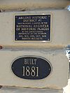
1
June 6, 2002 (#02000608 ) 4th St. at Poplar St. and Pine St. 38°55′10″N 97°13′38″W / 38.919444°N 97.227222°W / 38.919444; -97.227222 (Abilene City Park Historic District ) Abilene
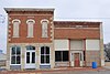
2
Abilene Downtown Historic District
September 1, 2009 (#09000673 ) Roughly bounded by Northeast 4th, West 1st, South Walnut, and North Olive Street 38°55′02″N 97°12′51″W / 38.917222°N 97.214167°W / 38.917222; -97.214167 (Abilene Downtown Historic District ) Abilene
3
January 11, 2006 (#05001514 ) 301, 303, 305, 307, and 309 N. Buckeye 38°55′02″N 97°12′48″W / 38.917222°N 97.213333°W / 38.917222; -97.213333 (Abilene Historic District No. 1 ) Abilene
4
September 2, 1993 (#93000894 ) 110 N. Cedar St. 38°54′58″N 97°13′01″W / 38.916111°N 97.216944°W / 38.916111; -97.216944 (Abilene Union Pacific Railroad Freight Depot ) Abilene
5
September 8, 1992 (#92001175 ) Junction of N. 2nd St. and Broadway 38°54′59″N 97°12′54″W / 38.916389°N 97.215°W / 38.916389; -97.215 (Abilene Union Pacific Railroad Passenger Depot ) Abilene
6
ATSF Steam Locomotive No. 3415
April 16, 2012 (#12000203 ) 411 S. Elm St. 38°54′49″N 97°13′18″W / 38.913693°N 97.221583°W / 38.913693; -97.221583 (ATSF Steam Locomotive No. 3415 ) Abilene
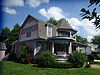
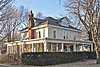
7
Berger House
June 27, 2007 (#07000606 ) 208 NE 12th St. 38°55′37″N 97°12′40″W / 38.926944°N 97.211111°W / 38.926944; -97.211111 (Berger House ) Abilene
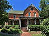
8
John W. Birchmore House
April 7, 2014 (#14000116 ) 1204 N. Buckeye Ave. 38°55′39″N 97°12′53″W / 38.927455°N 97.214821°W / 38.927455; -97.214821 (John W. Birchmore House ) Abilene
9
Upload image July 18, 2000 (#00000770 ) Solomon City Park, 100 E. 4th St. 38°55′03″N 97°22′13″W / 38.9175°N 97.370278°W / 38.9175; -97.370278 (Brewer Scout Cabin ) Solomon
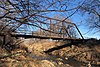
10
Chapman Creek Pratt Truss Bridge
May 9, 2003 (#03000375 ) Quail Rd., 1.7 miles (2.7 km) south of intersection with Highway 18 , 2.5 miles (4.0 km) north of Chapman 39°00′31″N 97°02′12″W / 39.008611°N 97.036667°W / 39.008611; -97.036667 (Chapman Creek Pratt Truss Bridge ) Chapman
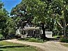
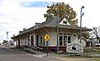
11
April 14, 1995 (#95000444 ) 813 N. Olive St. 38°55′24″N 97°12′35″W / 38.923333°N 97.209722°W / 38.923333; -97.209722 (Emerson Coulson House ) Abilene
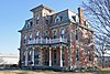
12
Eisenhower Home
January 25, 1971 (#71000306 ) 201 SE 4th St. 38°54′45″N 97°12′42″W / 38.9125°N 97.211667°W / 38.9125; -97.211667 (Eisenhower Home ) Abilene
13
April 8, 2009 (#09000189 ) 174 Highway 4 38°41′00″N 97°21′46″W / 38.683333°N 97.362778°W / 38.683333; -97.362778 (Eliason Barn ) Holland Township Agriculture-Related Resources of Kansas MPS
14
July 10, 2008 (#08000644 ) 201 W. 1st St. 38°54′55″N 97°12′53″W / 38.915278°N 97.214722°W / 38.915278; -97.214722 (Elms Hotel ) Abilene
15
January 11, 2017 (#100000506 ) 102 Highland Dr. 38°55′45″N 97°12′52″W / 38.929170°N 97.214308°W / 38.929170; -97.214308 (Jacob S. Engle House ) Abilene
16
November 14, 2002 (#02001266 ) 3052 Quail Rd. 39°02′04″N 97°02′09″W / 39.034444°N 97.035833°W / 39.034444; -97.035833 (Freeman-Zumbrunn House ) Chapman
17
November 4, 2009 (#09000874 ) 300 NW 7th St. 38°55′18″N 97°12′56″W / 38.921603°N 97.215675°W / 38.921603; -97.215675 (Garfield Elementary School ) Abilene
18
July 3, 2012 (#12000384 ) 400 N. Cedar St. 38°55′07″N 97°13′01″W / 38.918702°N 97.216893°W / 38.918702; -97.216893 (David R. Gordon House ) Abilene
19
June 25, 1987 (#87000953 ) 102 S. Broadway 38°40′05″N 96°56′30″W / 38.668056°N 96.941667°W / 38.668056; -96.941667 (Herington Carnegie Public Library ) Herington
20
January 11, 2017 (#100000510 ) 102-104 S. Factory St. 38°54′18″N 97°07′02″W / 38.904922°N 97.117330°W / 38.904922; -97.117330 (Hoffman and Lamb Buildings ) Enterprise
21
July 8, 2010 (#10000448 ) 2250 2100 Ave. 38°53′46″N 96°58′23″W / 38.896111°N 96.973056°W / 38.896111; -96.973056 (J.S. Hollinger Farmstead ) Chapman
22
May 25, 2001 (#01000539 ) 409 NW 3rd St. 38°54′59″N 97°13′01″W / 38.916389°N 97.216944°W / 38.916389; -97.216944 (Hotel Sunflower ) Abilene
23
September 20, 1991 (#91001437 ) 214 N. Walnut 38°55′05″N 97°13′10″W / 38.918056°N 97.219444°W / 38.918056; -97.219444 (John Johntz House ) Abilene
24
October 9, 2013 (#13000815 ) 101 S. Buckeye Ave. 38°54′54″N 97°12′51″W / 38.91506°N 97.214186°W / 38.91506; -97.214186 (Gustave A. Kubach House ) Abilene
25
Lander Park Carousel
February 27, 1987 (#87000813 ) 412 S. Campbell St. 38°54′41″N 97°12′31″W / 38.911389°N 97.208611°W / 38.911389; -97.208611 (Lander Park Carousel ) Abilene
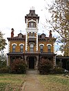
26
C.H. Lebold House
May 8, 1973 (#73000751 ) 106 N. Vine St. 38°54′56″N 97°13′24″W / 38.915556°N 97.223333°W / 38.915556; -97.223333 (C.H. Lebold House ) Abilene
27
July 14, 2000 (#00000789 ) 702 North Cedar 38°55′19″N 97°12′59″W / 38.921944°N 97.216389°W / 38.921944; -97.216389 (Litts-Dieter House ) Abilene
28
July 14, 2000 (#00000790 ) 813 NW 3rd St. 38°55′01″N 97°13′28″W / 38.916944°N 97.224444°W / 38.916944; -97.224444 (Mead-Rogers House ) Abilene
29
November 28, 2007 (#07001224 ) 800 N. Buckeye; 801, 803, 805 Spruceway; 106 Naroma Ct. 38°55′21″N 97°12′52″W / 38.9225°N 97.214444°W / 38.9225; -97.214444 (Naroma Court Historic District ) Abilene
30
December 31, 1998 (#98001561 ) 115 NW 3rd and 118 NW 2nd Sts. 38°55′05″N 97°12′52″W / 38.918056°N 97.214444°W / 38.918056; -97.214444 (Perring Building ) Abilene
31
February 19, 1982 (#82002654 ) Southeast of Chapman 38°52′52″N 96°59′09″W / 38.881111°N 96.985833°W / 38.881111; -96.985833 (Prospect Park Farm ) Chapman
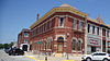
32
April 12, 2010 (#10000177 ) 200 SE Fifth St. 38°54′38″N 97°12′43″W / 38.910556°N 97.211944°W / 38.910556; -97.211944 (Rock Island Depot ) Abilene
33
St. John's Episcopal Church
May 25, 2001 (#01000537 ) 519 N. Buckeye Ave. 38°55′12″N 97°12′47″W / 38.92°N 97.213056°W / 38.92; -97.213056 (St. John's Episcopal Church ) Abilene
34
April 25, 1986 (#86000859 ) 1105 N. Buckeye 38°55′36″N 97°12′45″W / 38.926667°N 97.2125°W / 38.926667; -97.2125 (A. B. Seelye House ) Abilene
35
August 31, 1995 (#95001053 ) 217 W. 1st St. 38°54′53″N 97°13′04″W / 38.914722°N 97.217778°W / 38.914722; -97.217778 (D.G. Smith Building ) Abilene
36
July 7, 2015 (#15000381 ) 522 Golf Course Rd. 38°58′16″N 97°02′08″W / 38.9711°N 97.0355°W / 38.9711; -97.0355 (Smoky Hill Trail and Butterfield Overland Despatch Segment ) Chapman
37
Staatz House
February 4, 2005 (#04001426 ) 1824 Wolf Rd. 38°51′41″N 96°55′34″W / 38.861389°N 96.926111°W / 38.861389; -96.926111 (Staatz House ) Junction City
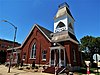
38
Trinity Evangelical Lutheran Church
November 1, 2006 (#06000965 ) 320 N. Cedar St. 38°55′05″N 97°13′00″W / 38.918056°N 97.216667°W / 38.918056; -97.216667 (Trinity Evangelical Lutheran Church ) Abilene
39
September 20, 2021 (#100007020 ) 205 South Cedar St. 38°54′50″N 97°13′00″W / 38.9138°N 97.2167°W / 38.9138; -97.2167 (Union Electric Warehouse ) Abilene
40
May 25, 2001 (#01000538 ) 300 N. Cedar St. 38°55′03″N 97°13′00″W / 38.9175°N 97.216667°W / 38.9175; -97.216667 (United Building ) Abilene
41
October 17, 1989 (#89001641 ) 17 E. Main St. 38°40′11″N 96°56′29″W / 38.669722°N 96.941389°W / 38.669722; -96.941389 (US Post Office-Herington ) Herington
42
Versteeg-Swisher House
March 23, 2005 (#05000201 ) 506 S. Campbell 38°54′36″N 97°12′14″W / 38.91°N 97.203889°W / 38.91; -97.203889 (Versteeg-Swisher House ) Abilene
43
July 2, 2018 (#100002622 ) 301 to 415 N Vine & 808-810 NW 3rd Sts. 38°55′03″N 97°13′24″W / 38.9176°N 97.2232°W / 38.9176; -97.2232 (Vine Street Historic District ) Abilene
44
January 28, 2004 (#03001494 ) 2291 2100 Ave. 38°53′36″N 96°57′55″W / 38.893333°N 96.965278°W / 38.893333; -96.965278 (Wheatland Farm Historic District ) Chapman
45
Wilson Pratt Truss Bridge
January 22, 2009 (#08001349 ) 2.9 miles (4.7 km) west of Rain Rd. on 3200 Ave. 39°03′38″N 97°04′21″W / 39.060442°N 97.072575°W / 39.060442; -97.072575 (Wilson Pratt Truss Bridge ) Chapman