National Register of Historic Places listings in Pawnee County, Kansas

Location of Pawnee County in Kansas
This is a list of the National Register of Historic Places listings in Pawnee County, Kansas. It is intended to be a complete list of the properties and districts on the National Register of Historic Places in Pawnee County, Kansas, United States. The locations of National Register properties and districts for which the latitude and longitude coordinates are included below, may be seen in an online map.
There are 8 properties and districts listed on the National Register in the county.
- This National Park Service list is complete through NPS recent listings posted February 11, 2022.[1]
Current listings[]
| [2] | Name on the Register[3] | Image | Date listed[4] | Location | City or town | Description |
|---|---|---|---|---|---|---|
| 1 | 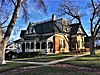 |
April 20, 1995 (#95000477) |
423 W. 5th St. 38°10′41″N 99°06′11″W / 38.178056°N 99.103056°W | Larned | ||
| 2 | July 17, 2013 (#13000493) |
1.5 miles southwest of Garfield on US 56 38°03′55″N 99°15′32″W / 38.065363°N 99.258960°W | Garfield | Santa Fe Trail Multiple Property Submission | ||
| 3 | Fort Larned National Historic Site | 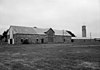 |
October 15, 1966 (#66000107) |
6 miles west of Larned on U.S. Route 156 38°09′24″N 99°13′36″W / 38.156667°N 99.226667°W | Larned | |
| 4 | May 3, 1976 (#76000836) |
Address restricted | Larned | |||
| 5 | Ooten House | March 2, 2001 (#01000188) |
507 W. 15th St. 38°11′21″N 99°06′14″W / 38.189167°N 99.103889°W | Larned | ||
| 6 | Patterson House | March 2, 2001 (#01000189) |
841 W. 8th St. 38°10′53″N 99°06′32″W / 38.181389°N 99.108889°W | Larned | ||
| 7 | July 17, 2013 (#13000494) |
Address Restricted | Larned | Santa Fe Trail Multiple Property Submission | ||
| 8 | July 2, 1985 (#85001442) |
Off U.S. Route 156, 3 miles west of Rozel 38°12′18″N 99°27′35″W / 38.205°N 99.459722°W | Rozel |

See also[]
- List of National Historic Landmarks in Kansas
- National Register of Historic Places listings in Kansas
References[]
- ^ National Park Service, United States Department of the Interior, "National Register of Historic Places: Weekly List Actions", retrieved February 11, 2022.
- ^ Numbers represent an alphabetical ordering by significant words. Various colorings, defined here, differentiate National Historic Landmarks and historic districts from other NRHP buildings, structures, sites or objects.
- ^ "National Register Information System". National Register of Historic Places. National Park Service. July 9, 2010.
- ^ The eight-digit number below each date is the number assigned to each location in the National Register Information System database, which can be viewed by clicking the number.
External links[]
| Wikimedia Commons has media related to National Register of Historic Places in Pawnee County, Kansas. |
|  | ||
| Topics | |
|---|---|
| Lists by state |
|
| Lists by insular areas | |
| Lists by associated state | |
| Other areas | |
| Related | |
| |
Municipalities and communities of Pawnee County, Kansas, United States | ||
|---|---|---|
| Cities |  | |
| Unincorporated communities | ||
| Townships |
| |
| ||
Categories:
- National Register of Historic Places in Pawnee County, Kansas
- Lists of National Register of Historic Places in Kansas by county