[3] Name on the Register[4]
Image
Date listed[5]
Location
City or town
Description
1
October 12, 2004 (#04001142 ) 200-210 Seneca St.; also 100 N. 2nd St. 39°19′11″N 94°54′35″W / 39.319722°N 94.909722°W / 39.319722; -94.909722 (Abernathy Furniture Company Factory ) Leavenworth Second set of addresses represent a boundary increase of April 5, 2016
2
November 17, 1977 (#77000586 ) 714 S. Broadway 39°18′38″N 94°55′15″W / 39.310556°N 94.920833°W / 39.310556; -94.920833 (A.J. Angell House ) Leavenworth
3
Upload image July 3, 2002 (#02000718 ) Roughly bounded by Arch, Pine, S. Second and S. Third Sts. 39°18′34″N 94°54′33″W / 39.309444°N 94.909167°W / 39.309444; -94.909167 (Arch Street Historic District ) Leavenworth
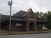
4
June 11, 1986 (#86001321 ) 781 Shawnee St. 39°19′00″N 94°55′28″W / 39.316667°N 94.924444°W / 39.316667; -94.924444 (Atchison, Topeka and Santa Fe Railroad Passenger Depot ) Leavenworth
5
March 17, 1972 (#72000509 ) 205 S. 5th St. 39°19′04″N 94°54′53″W / 39.317778°N 94.914722°W / 39.317778; -94.914722 (AXA Building ) Leavenworth
6
May 9, 2003 (#03000373 ) Two unnamed farm roads flanking Stranger Creek, 1.1 miles west of junction with 227th St. and Roe Rd., 1.75 miles northwest of Millwood 39°24′39″N 95°07′25″W / 39.410833°N 95.123611°W / 39.410833; -95.123611 (Begley Bridge ) Millwood
7
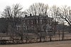
February 23, 1972 (#72000508 ) 403 5th Ave. 39°18′22″N 94°55′02″W / 39.306111°N 94.917222°W / 39.306111; -94.917222 (David J. Brewer House ) Leavenworth
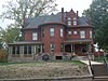
8
Nathaniel H. Burt House
October 27, 1987 (#87001105 ) 1200 5th Ave. 39°18′22″N 94°55′05″W / 39.306111°N 94.917917°W / 39.306111; -94.917917 (Nathaniel H. Burt House ) Leavenworth
9
Upload image September 6, 2005 (#05000973 ) Address restricted Tonganoxie
10
October 2, 1986 (#86002806 ) 1128 5th Ave. 39°18′24″N 94°55′05″W / 39.306667°N 94.918056°W / 39.306667; -94.918056 (Edward Carroll House ) Leavenworth
11
Upload image February 3, 2020 (#100004927 ) 10388 222nd St. 38°57′49″N 95°05′37″W / 38.9636°N 95.0936°W / 38.9636; -95.0936 (Delaware Cemetery ) Linwood
12
Upload image October 28, 2004 (#04001190 ) Address restricted Tonganoxie
13
First Presbyterian Church, Leavenworth
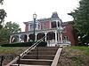
January 11, 2006 (#05001515 ) 407 Walnut St. 39°18′49″N 94°54′47″W / 39.313611°N 94.913056°W / 39.313611; -94.913056 (First Presbyterian Church, Leavenworth ) Leavenworth
14
Fort Leavenworth
October 15, 1966 (#66000346 ) Fort Leavenworth Military Reservation 39°21′11″N 94°55′01″W / 39.353056°N 94.916944°W / 39.353056; -94.916944 (Fort Leavenworth ) Leavenworth
15
Fort Leavenworth National Cemetery
July 15, 1999 (#99000834 ) Within Fort Leavenworth Military Reservation 39°21′05″N 94°55′48″W / 39.351389°N 94.93°W / 39.351389; -94.93 (Fort Leavenworth National Cemetery ) Fort Leavenworth
16
Upload image November 5, 1974 (#74000841 ) Northwest of Linwood on K-32 39°00′15″N 95°02′36″W / 39.004167°N 95.043333°W / 39.004167; -95.043333 (Senator William A. Harris House ) Linwood
17
April 26, 1972 (#72000510 ) 624 Olive St. 39°18′41″N 94°55′01″W / 39.311389°N 94.916944°W / 39.311389; -94.916944 (Fred Harvey House ) Leavenworth
18
October 8, 2009 (#09000809 ) 300 Santa Fe St./2500 2nd St. 39°17′32″N 94°54′25″W / 39.292356°N 94.906858°W / 39.292356; -94.906858 (Helmers Manufacturing Company Building ) Leavenworth
19
Hollywood Theater
October 25, 1990 (#90001575 ) 401 Delaware St. 39°19′05″N 94°54′54″W / 39.318056°N 94.915°W / 39.318056; -94.915 (Hollywood Theater ) Leavenworth
20
Hund School
March 9, 2000 (#00000158 ) 31874 179th St. 39°21′01″N 94°59′32″W / 39.3503°N 94.9922°W / 39.3503; -94.9922 (Hund School ) Leavenworth
21
October 2, 1986 (#86002801 ) 602 Seneca St. 39°18′48″N 94°55′08″W / 39.3133°N 94.9189°W / 39.3133; -94.9189 (Merritt Insley House and Outbuildings ) Leavenworth
22
Upload image October 6, 2011 (#11000725 ) 25761 151st. St. 39°14′27″N 94°55′56″W / 39.2408°N 94.9322°W / 39.2408; -94.9322 (Horace and Rosemond Lamborn Farmstead ) Leavenworth
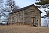
23
Upload image March 24, 1971 (#71000316 ) Address restricted Lansing
24
April 26, 2002 (#02000394 ) 300 Walnut St. 39°18′19″N 94°54′43″W / 39.3053°N 94.9119°W / 39.3053; -94.9119 (Leavenworth County Courthouse ) Leavenworth
25
April 26, 2002 (#02000389 ) Roughly Cherokee St., Delaware St., S. Fifth St., and Shawnee St. 39°19′05″N 94°54′55″W / 39.3180°N 94.9154°W / 39.3180; -94.9154 (Leavenworth Downtown Historic District ) Leavenworth
26
Upload image April 29, 2002 (#02000406 ) Roughly Third St. Choctaw St., Second St. and Cherokee St. 39°19′00″N 94°54′36″W / 39.3167°N 94.91°W / 39.3167; -94.91 (Leavenworth Historic Industrial District ) Leavenworth
27
Leavenworth Public Library
July 30, 1986 (#86002010 ) 601 S. Fifth St. 39°18′48″N 94°54′55″W / 39.3133°N 94.9153°W / 39.3133; -94.9153 (Leavenworth Public Library ) Leavenworth
28
May 6, 2009 (#09000274 ) 306 S. 7th St. 39°18′59″N 94°55′06″W / 39.3165°N 94.9182°W / 39.3165; -94.9182 (Leavenworth Terminal Railway & Bridge Company Freight Depot ) Leavenworth
29
January 7, 2015 (#14001120 ) Northeastern corner of Tonganoxie and Stranger Rds. 39°14′43″N 94°58′26″W / 39.2452°N 94.974°W / 39.2452; -94.974 (Little Stranger Church and Cemetery ) Leavenworth
30
Upload image July 3, 2002 (#02000719 ) Along N. Broadway between Seneca and Ottawa Sts. 39°19′15″N 94°55′18″W / 39.3208°N 94.9217°W / 39.3208; -94.9217 (North Broadway Historic District ) Leavenworth
31
October 6, 2011 (#11000726 ) 801 N. Broadway St. 39°19′29″N 94°55′24″W / 39.3247°N 94.9233°W / 39.3247; -94.9233 (North Broadway School ) Leavenworth
32
Upload image December 12, 1977 (#77000587 ) 203-515 N. Esplanade 39°19′20″N 94°54′36″W / 39.3222°N 94.91°W / 39.3222; -94.91 (North Esplanade Historic District ) Leavenworth
33
Old Union Depot
March 11, 1982 (#82002663 ) 201 S. Main St. 39°19′07″N 94°54′33″W / 39.3186°N 94.9092°W / 39.3186; -94.9092 (Old Union Depot ) Leavenworth Former Union Station, currently the Leavenworth Riverfront Community Center
34
Upload image September 6, 2005 (#05000977 ) Address restricted Tonganoxie
35
August 30, 1977 (#77000588 ) 2 miles northwest of Leavenworth off U.S. Route 73 39°21′00″N 94°57′44″W / 39.35°N 94.9622°W / 39.35; -94.9622 (David W. Powers House ) Leavenworth
36
Upload image April 23, 1973 (#73000761 ) Northern side of McPherson Avenue immediately west of Sylvan Trail[6] : 122 39°21′38″N 94°55′36″W / 39.3606°N 94.9267°W / 39.3606; -94.9267 (Quarry Creek Archeological Site ) Leavenworth Along with the McPherson Site on the other side of McPherson Avenue, the largest Kansas City Hopewell site in the Leavenworth area[6] : 121
37
Upload image October 29, 2004 (#04001189 ) Address restricted Tonganoxie
38
Upload image September 23, 2020 (#100005624 ) 711 North Broadway St. 39°19′26″N 94°55′21″W / 39.3238°N 94.9226°W / 39.3238; -94.9226 (William Small Memorial Home for Aged Women ) Leavenworth
39
Upload image July 3, 2002 (#02000720 ) Roughly bounded by Arch, Olive and S. Second Sts. and railroad 39°18′38″N 94°54′26″W / 39.3106°N 94.9072°W / 39.3106; -94.9072 (South Esplanade Historic District ) Leavenworth
40
Upload image June 29, 2018 (#100002626 ) 19801 Tonganoxie Dr. 39°07′56″N 95°03′29″W / 39.1323°N 95.0581°W / 39.1323; -95.0581 (Stonehaven Farm ) Tonganoxie
41
Upload image August 4, 2011 (#11000504 ) 1501 5th Ave. 39°18′10″N 94°55′01″W / 39.3028°N 94.9169°W / 39.3028; -94.9169 (Sumner Elementary School ) Leavenworth
42
Upload image July 3, 2002 (#02000721 ) Roughly bounded by 2nd and Aves. and Congress and Middle Sts. 39°18′27″N 94°54′53″W / 39.3075°N 94.9147°W / 39.3075; -94.9147 (Third Avenue Historic District ) Leavenworth
43
Upload image July 3, 2002 (#02000722 ) Roughly bounded by Chestnut, Congress, S. 6th, and W. 7th Sts. 39°18′39″N 94°55′00″W / 39.3108°N 94.9167°W / 39.3108; -94.9167 (Union Park Historic District ) Leavenworth
44
Western Branch, National Home for Disabled Volunteer Soldiers
April 30, 1999 (#99000456 ) 4101 S. 4th St. 39°16′43″N 94°53′29″W / 39.2786°N 94.8914°W / 39.2786; -94.8914 (Western Branch, National Home for Disabled Volunteer Soldiers ) Leavenworth National Historic Landmark designation June 23, 2011
45
Upload image January 8, 1987 (#86003517 ) Left bank of Salt Creek above its confluence with the Missouri River [7] 39°22′00″N 94°57′11″W / 39.3667°N 94.9531°W / 39.3667; -94.9531 (Zacharias Site (14LV380) ) Leavenworth