[3] Name on the Register[4]
Image
Date listed[5]
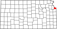
Location
City or town
Description
1
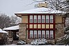
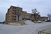
Argentine Carnegie Library
April 30, 1986 (#86000919 ) 1400 Joseph J. Segura Ln 39°04′27″N 94°39′40″W / 39.074091°N 94.661194°W / 39.074091; -94.661194 (Argentine Carnegie Library ) Kansas City
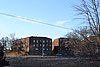
2
Upload image July 11, 2002 (#02000761 ) 200 E. 3rd 39°03′28″N 94°52′57″W / 39.057778°N 94.8825°W / 39.057778; -94.8825 (Bonner Springs High School ) Bonner Springs
3
Upload image July 12, 2019 (#100004198 ) 753 State Ave., & 754-756 Minnesota Ave. 39°06′59″N 94°37′45″W / 39.1165°N 94.6293°W / 39.1165; -94.6293 (Brotherhood Block ) Kansas City
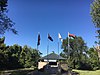
4
Castle Rock
February 18, 2000 (#00000109 ) 852 Washington Boulevard 39°07′08″N 94°37′56″W / 39.118765°N 94.632142°W / 39.118765; -94.632142 (Castle Rock ) Kansas City
5
June 30, 2007 (#07000608 ) Bounded by Esplanade Ave., Brown Ave., and 12th St., including both sides of Parkwood Boulevard, Coronado Rd. and Hilltop Rd. 39°08′37″N 94°38′17″W / 39.143519°N 94.638042°W / 39.143519; -94.638042 (Fairfax Hills Historic District ) Kansas City
6
Fire Station No. 9
September 5, 1985 (#85001982 ) 2 S. 14th St. 39°06′14″N 94°38′42″W / 39.103870°N 94.645117°W / 39.103870; -94.645117 (Fire Station No. 9 ) Kansas City
7
June 26, 2013 (#13000437 ) 1403 Metropolitan Ave. 39°04′21″N 94°38′43″W / 39.072388°N 94.645313°W / 39.072388; -94.645313 (Franklin Elementary School ) Kansas City
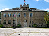
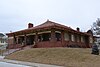
8
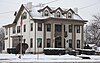
Judge Louis Gates House
December 1, 1980 (#80001477 ) 4146 Cambridge St. 39°03′08″N 94°36′31″W / 39.052222°N 94.608688°W / 39.052222; -94.608688 (Judge Louis Gates House ) Kansas City
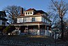
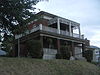
9
Granada Theater
February 9, 2005 (#05000004 ) 1013-1019 Minnesota Ave. 39°06′55″N 94°38′10″W / 39.115333°N 94.635975°W / 39.115333; -94.635975 (Granada Theater ) Kansas City
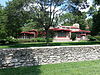
10
Grinter Place
January 25, 1971 (#71000338 ) 1420 S. 78th St. 39°04′30″N 94°45′37″W / 39.074907°N 94.760167°W / 39.074907; -94.760167 (Grinter Place ) Kansas City
11
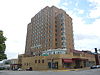
H.W. Gates Funeral Home
July 6, 2010 (#10000430 ) 1901 Olathe Blvd. 39°03′15″N 94°36′27″W / 39.054058°N 94.607620°W / 39.054058; -94.607620 (H.W. Gates Funeral Home ) Kansas City
12
Hanover Heights Neighborhood Historic District
May 17, 1990 (#90000776 ) Roughly bounded by Olathe Boulevard, Frances St., 43rd Ave., and State Line Rd. 39°03′09″N 94°36′38″W / 39.0525°N 94.610556°W / 39.0525; -94.610556 (Hanover Heights Neighborhood Historic District ) Kansas City
13
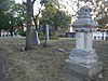
Huron Cemetery
September 3, 1971 (#71000335 ) On Minnesota Ave. between 6th and 7th Sts. 39°06′53″N 94°37′34″W / 39.114722°N 94.626111°W / 39.114722; -94.626111 (Huron Cemetery ) Kansas City
14
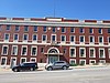
Kansas City, Kansas City Hall and Fire Headquarters
April 25, 1986 (#86000857 ) 805 and 815 N. 6th St. 39°06′51″N 94°37′24″W / 39.114167°N 94.623333°W / 39.114167; -94.623333 (Kansas City, Kansas City Hall and Fire Headquarters ) Kansas City Boundary increase approved January 6, 2022
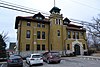
15
Kansas City, Kansas High School Gymnasium and Laboratory
January 20, 2012 (#11001038 ) 1017 N. 9th St. 39°06′59″N 94°37′55″W / 39.116264°N 94.632031°W / 39.116264; -94.632031 (Kansas City, Kansas High School Gymnasium and Laboratory ) Kansas City
16
July 12, 2019 (#100004199 ) 900 N. 8th St. 39°06′53″N 94°37′47″W / 39.1148°N 94.6296°W / 39.1148; -94.6296 (Kansas City, Kansas YMCA Building ) Kansas City
17
Upload image January 22, 1996 (#95001553 ) K-32 39°03′57″N 94°50′24″W / 39.065833°N 94.84°W / 39.065833; -94.84 (Lake of the Forest Historic District ) Bonner Springs
18
January 31, 2008 (#07001485 ) 1040 Orville Ave. 39°06′36″N 94°38′14″W / 39.110035°N 94.637182°W / 39.110035; -94.637182 (Lowell Elementary School ) Kansas City
19
January 20, 2012 (#11001037 ) 824 State Ave. 39°07′01″N 94°37′51″W / 39.116839°N 94.630883°W / 39.116839; -94.630883 (Horace Mann Elementary School ) Kansas City
20
October 9, 2013 (#13000819 ) 600 Oakland Ave. 39°07′15″N 94°37′29″W / 39.120805°N 94.624772°W / 39.120805; -94.624772 (Cordell D. Meeks Sr. House ) Kansas City
21
October 16, 2008 (#08000988 ) 400 Troup Ave. 39°07′39″N 94°37′05″W / 39.1276°N 94.6181°W / 39.1276; -94.6181 (Northeast Junior High School ) Kansas City
22
Quindaro Townsite
May 22, 2002 (#02000547 ) Parallel Parkway and N. 38th St.[6] 39°07′46″N 94°40′22″W / 39.1294°N 94.6728°W / 39.1294; -94.6728 (Quindaro Townsite ) Kansas City
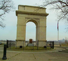
23
Rosedale World War I Memorial Arch
August 2, 1977 (#77000599 ) Mt. Marty Park near Booth and Drexel Sts. 39°03′50″N 94°36′54″W / 39.0639°N 94.615°W / 39.0639; -94.615 (Rosedale World War I Memorial Arch ) Kansas City
24
February 24, 1971 (#71000336 ) 3301 Parallel Ave. 39°07′39″N 94°40′08″W / 39.1275°N 94.6689°W / 39.1275; -94.6689 (St. Augustine Hall ) Kansas City
25
January 2, 2013 (#12001123 ) 263 S. 8th St., 759 Vermont Ave. 39°05′50″N 94°37′45″W / 39.0972°N 94.6291°W / 39.0972; -94.6291 (Saint Margaret's Hospital ) Kansas City
26
Sauer Castle
August 2, 1977 (#77000600 ) 945 Shawnee Dr. 39°04′07″N 94°38′00″W / 39.0687°N 94.6333°W / 39.0687; -94.6333 (Sauer Castle ) Kansas City
27
October 10, 2007 (#07001072 ) 608 Splitlog Ave. 39°06′33″N 94°37′28″W / 39.1093°N 94.6244°W / 39.1093; -94.6244 (Schleifer-McAlpine House ) Kansas City
28
Scottish Rite Temple
September 11, 1985 (#85002127 ) 803 N. 7th St. 39°06′50″N 94°37′34″W / 39.1139°N 94.6261°W / 39.1139; -94.6261 (Scottish Rite Temple ) Kansas City
29
February 18, 2000 (#00000108 ) 2518 N. 10th St. 39°08′04″N 94°38′07″W / 39.1345°N 94.6353°W / 39.1345; -94.6353 (Theodore Shafer House ) Kansas City
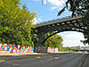
30
Shawnee Street Overpass
March 8, 1984 (#84001245 ) Northwest of U.S. Route 35 39°04′19″N 94°37′15″W / 39.0719°N 94.6208°W / 39.0719; -94.6208 (Shawnee Street Overpass ) Kansas City Location was at Shawnee Road and 7th Street Traffic-way;[7]
31
January 8, 2014 (#13001046 ) 1404 S. 37th St. 39°04′29″N 94°40′18″W / 39.0748°N 94.6717°W / 39.0748; -94.6717 (Simmons Funeral Home ) Kansas City
32
Soldiers and Sailors Memorial Building
September 5, 1985 (#85001981 ) 600 N. 7th St. 39°06′44″N 94°37′38″W / 39.1122°N 94.6272°W / 39.1122; -94.6272 (Soldiers and Sailors Memorial Building ) Kansas City
33
September 6, 2005 (#05000974 ) 1610 N. 8th St. 39°07′15″N 94°37′49″W / 39.1208°N 94.6302°W / 39.1208; -94.6302 (Sumner High School and Athletic Field ) Kansas City
34
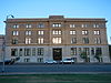
Town House Hotel
June 27, 2014 (#14000352 ) 1011 N. 7th St. Trafficway 39°06′59″N 94°37′35″W / 39.1165°N 94.6263°W / 39.1165; -94.6263 (Town House Hotel ) Kansas City Now Cross Lines Tower.
35
Trowbridge Archeological Site Upload image February 24, 1971 (#71000337 ) Between 61st and 63rd Sts., north of May Ln. and Leavenworth Rd.[8] 39°08′40″N 94°43′20″W / 39.1444°N 94.7222°W / 39.1444; -94.7222 (Trowbridge Archeological Site ) Kansas City
36
April 16, 2013 (#13000166 ) 5217 Leavenworth Rd 39°08′33″N 94°42′03″W / 39.1425°N 94.7009°W / 39.1425; -94.7009 (Welborn Community Congregational Church ) Kansas City
37
July 7, 2015 (#15000388 ) 1601-1637 Washington Blvd. 39°07′12″N 94°38′52″W / 39.1199°N 94.6477°W / 39.1199; -94.6477 (Westheight Apartments Historic District ) Kansas City
38
March 26, 1975 (#75000729 ) Bounded roughly by 18th and 24th Sts. and Oakland and State Aves.; also roughly bounded by State and Wood Aves. and 18th and 25th Sts. 39°07′07″N 94°39′09″W / 39.1186°N 94.6525°W / 39.1186; -94.6525 (Westheight Manor District ) Kansas City Second set of addresses represents a boundary increase
39
Whitefeather Spring
August 27, 1975 (#75000728 ) 3818 Ruby Ave. 39°04′18″N 94°40′25″W / 39.0717°N 94.6736°W / 39.0717; -94.6736 (Whitefeather Spring ) Kansas City
40
Upload image April 18, 2007 (#07000311 ) 1865 Edwardsville Dr. 39°03′59″N 94°49′18″W / 39.0664°N 94.8218°W / 39.0664; -94.8218 (Roy Williamson House ) Edwardsville
41
Wyandotte County Courthouse
April 26, 2002 (#02000398 ) 710 N. 7th St. 39°06′51″N 94°37′38″W / 39.1142°N 94.6272°W / 39.1142; -94.6272 (Wyandotte County Courthouse ) Kansas City
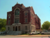
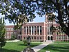
42
Wyandotte High School
April 30, 1986 (#86000920 ) 2500 Minnesota Ave. 39°06′52″N 94°39′21″W / 39.1144°N 94.6558°W / 39.1144; -94.6558 (Wyandotte High School ) Kansas City