National Register of Historic Places listings in Marion County, Kansas

Location of Marion County in Kansas
This is a list of the National Register of Historic Places listings in Marion County, Kansas.
This is intended to be a complete list of the properties and districts on the National Register of Historic Places in Marion County, Kansas, United States. The locations of National Register properties and districts for which the latitude and longitude coordinates are included below, may be seen in a map.[1]
There are 31 properties and districts listed on the National Register in the county.
- This National Park Service list is complete through NPS recent listings posted February 11, 2022.[2]
Current listings[]
| [3] | Name on the Register[4] | Image | Date listed[5] | Location | City or town | Description |
|---|---|---|---|---|---|---|
| 1 | October 6, 2011 (#11000727) |
Lots 10 & 11, Block 2, Hill's 2nd Addition 38°21′15″N 97°12′25″W / 38.3542°N 97.2069°W | Hillsboro | |||
| 2 | January 21, 2004 (#03001467) |
0.5 miles west of U.S. Route 77 on 260th Street (approximate 1 mile north-east of Antelope) 38°26′47″N 96°57′58″W / 38.4464°N 96.9661°W | Antelope | |||
| 3 | December 17, 1987 (#87002114) |
5.25 miles east of Lincolnville on 290th Street 38°29′37″N 96°51′38″W / 38.4936°N 96.8606°W | Lincolnville | |||
| 4 |  |
January 28, 2004 (#03001498) |
4.5 miles east of Florence on U.S. Route 50, then 0.1 mile north on Bluestem Road 38°15′08″N 96°50′53″W / 38.2522°N 96.8481°W | Florence | ||
| 5 | April 14, 2015 (#15000146) |
412 N. 2nd St. 38°21′04″N 97°01′17″W / 38.3510°N 97.0213°W | Marion | |||
| 6 | Burns Union School |  |
March 26, 1975 (#75000714) |
Southwest corner of Ohio and Main Streets 38°05′20″N 96°53′14″W / 38.0889°N 96.8872°W | Burns | Currently the Burns Community Museum.[6] |
| 7 | October 11, 2016 (#16000705) |
Address Restricted | Durham | |||
| 8 | September 23, 2020 (#100005122) |
318 East Main St. 38°20′54″N 97°01′11″W / 38.3482°N 97.0196°W | Marion | |||
| 9 | October 11, 2000 (#98000266) |
0.3 mile south of Florence railroad track on Main Street 38°14′04″N 96°55′33″W / 38.2344°N 96.9258°W | Florence | |||
| 10 | September 13, 1978 (#78001286) |
115 North 3rd Street 38°20′56″N 97°01′11″W / 38.3489°N 97.0197°W | Marion | |||
| 11 |  |
January 18, 2011 (#10001142) |
Southwest corner of 5th and Main Streets 38°14′32″N 96°55′36″W / 38.2422°N 96.9267°W | Florence | ||
| 12 |  |
May 6, 1973 (#09000275) |
525 West 5th Street 38°14′31″N 96°56′02″W / 38.2420°N 96.9338°W | Florence | ||
| 13 | April 3, 2013 (#13000131) |
Address Restricted | Lehigh | |||
| 14 | Harvey House |  |
August 14, 1973 (#73000763) |
221 North Marion Street 38°14′24″N 96°55′41″W / 38.24°N 96.9281°W | Florence | See Fred Harvey Company.[7] |
| 15 | May 28, 1976 (#76000827) |
601 East Main Street 38��20′54″N 97°00′54″W / 38.3483°N 97.015°W | Marion | |||
| 16 | May 11, 1995 (#95000579) |
3.5 miles south of Lincolnville on U.S. Route 77 (1 mile east of Antelope) 38°26′13″N 96°57′28″W / 38.4369°N 96.9578°W | Lincolnville | |||
| 17 | July 10, 2017 (#100001290) |
2910 47th Terrace 38°08′50″N 96°51′17″W / 38.1471°N 96.8546°W | Burns | |||
| 18 | September 30, 1976 (#76000826) |
2.5 miles west of Lost Springs on 340th Street 38°34′00″N 97°00′46″W / 38.5667°N 97.0128°W | Lost Springs | |||
| 19 | April 21, 1976 (#76000829) |
Various locations along Mud Creek and the Cottonwood River[8] 38°21′54″N 97°01′06″W / 38.3650°N 97.0183°W | Marion | |||
| 20 | Marion County Courthouse |  |
May 28, 1976 (#76000828) |
200 South 3rd Street 38°20′50″N 97°01′09″W / 38.3472°N 97.0192°W | Marion | |
| 21 | Marion County Park and Lake | June 6, 2002 (#02000607) |
1 mile east of Marion on 190th Street (Main), then 1.75 miles south on Upland Road 38°19′14″N 96°58′59″W / 38.3206°N 96.9831°W | Marion | ||
| 22 | November 28, 2007 (#07001227) |
401 North Columbus Street 38°32′54″N 97°09′22″W / 38.5483°N 97.1561°W | Tampa | |||
| 23 | W.H. Morgan House |  |
January 22, 1996 (#95001562) |
212 North Walnut Street 38°10′01″N 97°06′23″W / 38.1669°N 97.1064°W | Peabody | |
| 24 | Old Peabody Library |  |
July 2, 1973 (#73000765) |
106 East Division Avenue 38°10′02″N 97°06′22″W / 38.1672°N 97.1061°W | Peabody | Currently the Peabody Historical Museum.[9] |
| 25 | Peabody City Park | 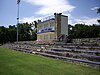 |
January 20, 2012 (#11001032) |
W. 2nd and Locust Sts. 38°09′58″N 97°06′45″W / 38.1662°N 97.1124°W | Peabody | |
| 26 | Peabody Downtown Historic District |  |
May 29, 1998 (#98000590) |
Walnut Street area, between Division and First Streets 38°09′57″N 97°06′25″W / 38.1658°N 97.1069°W | Peabody | |
| 27 | Peabody Township Carnegie Library | 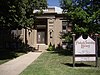 |
June 25, 1987 (#87000959) |
214 North Walnut Street 38°10′02″N 97°06′24″W / 38.1672°N 97.1067°W | Peabody | Currently the Peabody Township Library.[10] |
| 28 | March 30, 1973 (#73000764) |
501 South Ash Street 38°20′51″N 97°12′23″W / 38.3475°N 97.2064°W | Hillsboro | Currently the Peter Paul Loewen House.[11] | ||
| 29 | May 11, 1995 (#95000584) |
From corner of 270th St and Falcon Rd, parallels on west side of railroad tracks towards southwest 38°27′26″N 97°16′39″W / 38.4572°N 97.2775°W | Durham | |||
| 30 | May 16, 2002 (#02000490) |
312 East Grand Avenue 38°21′15″N 97°12′02″W / 38.3542°N 97.2006°W | Hillsboro | Currently the William F. Schaeffler House Museum.[12] | ||
| 31 | J.S. Schroeder Building | December 6, 1991 (#91001770) |
111 North Walnut Street 38°09′54″N 97°06′13″W / 38.165°N 97.1036°W | Peabody |
See also[]
| Wikimedia Commons has media related to National Register of Historic Places in Marion County, Kansas. |
- List of National Historic Landmarks in Kansas
- National Register of Historic Places listings in Kansas
References[]
- ^ The latitude and longitude information provided in this table was derived originally from the National Register Information System, which has been found to be fairly accurate for about 99% of listings. Some locations in this table may have been corrected to current GPS standards.
- ^ National Park Service, United States Department of the Interior, "National Register of Historic Places: Weekly List Actions", retrieved February 11, 2022.
- ^ Numbers represent an alphabetical ordering by significant words. Various colorings, defined here, differentiate National Historic Landmarks and historic districts from other NRHP buildings, structures, sites or objects.
- ^ "National Register Information System". National Register of Historic Places. National Park Service. April 24, 2008.
- ^ The eight-digit number below each date is the number assigned to each location in the National Register Information System database, which can be viewed by clicking the number.
- ^ Burns Union School - Official Website
- ^ Harvey House - Official Website
- ^ Roper, Donna C. "The Marion Great Bend Aspect Sites: Floodplain Settlement on the Plains". Plains Anthropologist 47.180 (2002): 17-32: 18.
- ^ Old Peabody Library - Website
- ^ Peabody Township Carnegie Library - Official Website
- ^ Pioneer Adobe House - Official Website
- ^ W.F. Schaeffler House - Official Website
|  | ||
Municipalities and communities of Marion County, Kansas, United States | ||
|---|---|---|
| Cities |  | |
| Unincorporated communities | ||
| Ghost towns | ||
| Townships | ||
| Footnotes | †This populated place is designated a Census-Designated Place (CDP) by the United States Census Bureau. ‡This populated place also has portions in an adjacent county or counties | |
| ||
Categories:
- Lists of National Register of Historic Places in Kansas by county
- National Register of Historic Places in Marion County, Kansas
- Buildings and structures in Marion County, Kansas