Location of Harvey County in Kansas
This is a list of the National Register of Historic Places listings in Harvey County, Kansas .
This is intended to be a complete list of the properties and districts on the National Register of Historic Places in Harvey County , Kansas , United States . The locations of National Register properties and districts for which the latitude and longitude coordinates are included below, may be seen in a map.[1]
There are 24 properties and districts listed on the National Register in the county, including 1 National Historic Landmark .
This National Park Service list is complete through NPS recent listings posted February 11, 2022. [2]
Current listings [ ]
[3] Name on the Register[4]
Image
Date listed[5]
Location
City or town
Description
1
Upload image October 10, 1996 (#96001081 ) 205 E. 5th 38°00′34″N 97°30′13″W / 38.009444°N 97.503611°W / 38.009444; -97.503611 (Bergtholdt House ) Halstead
2
Bethel College Administration Building
March 16, 1972 (#72000505 ) Bethel College campus 38°04′28″N 97°20′32″W / 38.074444°N 97.342222°W / 38.074444; -97.342222 (Bethel College Administration Building ) North Newton
3
Upload image October 17, 1988 (#88001904 ) 302 W. 6th 38°02′55″N 97°20′51″W / 38.048611°N 97.3475°W / 38.048611; -97.3475 (Samuel A. Brown House ) Newton
4
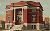
Carnegie Library
May 31, 1974 (#74000840 ) 203 Main St. 38°02′39″N 97°20′42″W / 38.044167°N 97.345°W / 38.044167; -97.345 (Carnegie Library ) Newton
5
Upload image March 2, 2001 (#01000186 ) 408 Mead St. 38°02′01″N 97°20′15″W / 38.033611°N 97.3375°W / 38.033611; -97.3375 (Coleman House ) Newton
6
Upload image October 31, 2002 (#02001267 ) 2512 N. College Ave. 38°04′20″N 97°20′17″W / 38.072222°N 97.338056°W / 38.072222; -97.338056 (David Goerz House ) North Newton
7
October 11, 2001 (#01001094 ) 116 E. 1st St. 38°00′21″N 97°30′17″W / 38.005833°N 97.504722°W / 38.005833; -97.504722 (Halstead Santa Fe Depot ) Halstead
8
Upload image April 12, 2001 (#01000362 ) 303 W. Broadway 38°03′05″N 97°20′54″W / 38.051389°N 97.348333°W / 38.051389; -97.348333 (E.H. Hoag House ) Newton
9
Upload image July 6, 2010 (#10000427 ) 128-130 East 6th St. 38°02′56″N 97°20′36″W / 38.048889°N 97.343333°W / 38.048889; -97.343333 (J.J. Krehbiel and Company Carriage Factory ) Newton
10
Upload image January 13, 2004 (#03001395 ) 406 W. 6th St. 38°02′56″N 97°21′03″W / 38.048889°N 97.350833°W / 38.048889; -97.350833 (Lincoln School ) Newton
11
Upload image July 9, 2008 (#08000670 ) Roughly E. 5th St., SE 3rd St., Allison St., and Walnut St. 38°02′26″N 97°20′38″W / 38.040556°N 97.343889°W / 38.040556; -97.343889 (McKinley Residential Historic District ) Newton
12
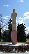
Mennonite Settler Statue
February 26, 1998 (#98000084 ) Athletic Park Dr. 38°02′45″N 97°21′23″W / 38.045833°N 97.356389°W / 38.045833; -97.356389 (Mennonite Settler Statue ) Newton
13
Upload image May 6, 1982 (#82002661 ) 301 E. 4th St. 38°02′45″N 97°20′26″W / 38.045833°N 97.340556°W / 38.045833; -97.340556 (Jairus Neal House ) Newton
14
Upload image November 15, 2003 (#03001145 ) 200 through 214 and 203 through 301 N. Main St. 38°02′48″N 97°20′43″W / 38.046667°N 97.345278°W / 38.046667; -97.345278 (Newton Main Street Historic District I ) Newton
15
November 15, 2003 (#03001146 ) 411-825 N. Main St. and 414-726 N. Main St. 38°02′57″N 97°20′43″W / 38.049167°N 97.345278°W / 38.049167; -97.345278 (Newton Main Street Historic District II ) Newton
16
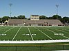
Newton Stadium
January 14, 2004 (#03001394 ) Athletic Park 38°02′41″N 97°21′23″W / 38.044722°N 97.356389°W / 38.044722; -97.356389 (Newton Stadium ) Newton
17
May 6, 1982 (#82002662 ) 500 Main St. 38°02′52″N 97°20′39″W / 38.047778°N 97.344167°W / 38.047778; -97.344167 (Old Railroad Savings and Loan Building ) Newton
18
Santa Fe Depot
April 11, 1985 (#85000735 ) 414 N. Main 38°02′58″N 97°20′39″W / 38.049444°N 97.344167°W / 38.049444; -97.344167 (Santa Fe Depot ) Newton
19
Upload image February 3, 2012 (#11001079 ) West side of the 500 block of N. Commercial Ave. 37°55′04″N 97°25′29″W / 37.917831°N 97.424708°W / 37.917831; -97.424708 (Sedgwick Downtown Historic District ) Sedgwick
20
Upload image October 17, 1989 (#89001640 ) 319 Main St. 38°00′08″N 97°30′22″W / 38.002222°N 97.506111°W / 38.002222; -97.506111 (US Post Office-Halstead ) Halstead
21
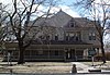
Warkentin House
January 12, 1970 (#70000250 ) 211 E. 1st St. 38°02′36″N 97°20′23″W / 38.043333°N 97.339722°W / 38.043333; -97.339722 (Warkentin House ) Newton
22
January 12, 1970 (#70000251 ) 3rd and Main Sts. 38°02′43″N 97°20′42″W / 38.045278°N 97.345°W / 38.045278; -97.345 (Warkentin Mill ) Newton
23
Bernhard Warkentin Homestead Upload image February 15, 1974 (#74000839 ) North of Halstead 38°00′27″N 97°30′08″W / 38.0075°N 97.502222°W / 38.0075; -97.502222 (Bernhard Warkentin Homestead ) Halstead
24
Upload image January 7, 2015 (#14001119 ) 2727 N. Main St. 38°04′28″N 97°20′43″W / 38.0745°N 97.3453°W / 38.0745; -97.3453 (Wirkler-Krehbiel House ) North Newton
See also [ ] References [ ]
^ The latitude and longitude information provided in this table was derived originally from the National Register Information System, which has been found to be fairly accurate for about 99% of listings. Some locations in this table may have been corrected to current GPS standards.
^ National Park Service, United States Department of the Interior , "National Register of Historic Places: Weekly List Actions" , retrieved February 11, 2022.
^ Numbers represent an alphabetical ordering by significant words. Various colorings, defined here , differentiate National Historic Landmarks and historic districts from other NRHP buildings, structures, sites or objects.
^ "National Register Information System" . National Register of Historic Places National Park Service . March 13, 2009.^ The eight-digit number below each date is the number assigned to each location in the National Register Information System database, which can be viewed by clicking the number.