National Register of Historic Places listings in Hanson County, South Dakota

Location of Hanson County in South Dakota
This is a list of the National Register of Historic Places listings in Hanson County, South Dakota.
This is intended to be a complete list of the properties on the National Register of Historic Places in Hanson County, South Dakota, United States. The locations of National Register properties for which the latitude and longitude coordinates are included below, may be seen in a map.[1]
There are 6 properties listed on the National Register in the county, including 1 National Historic Landmark. Another property was once listed but has since been removed.
- This National Park Service list is complete through NPS recent listings posted February 11, 2022.[2]
Current listings[]
| [3] | Name on the Register[4] | Image | Date listed[5] | Location | City or town | Description |
|---|---|---|---|---|---|---|
| 1 | Bloom Site |  |
October 15, 1966 (#66000714) |
Address Restricted | ||
| 2 | Fort James (39HS48) |  |
March 15, 1984 (#84003290) |
Address Restricted | Rosedale Colony | |
| 3 | Old Rockport Hutterite Colony | June 30, 1982 (#82003929) |
Off the James River 43°34′55″N 97°50′27″W / 43.581944°N 97.840833°W | Alexandria | ||
| 4 | |
March 15, 1984 (#84003292) |
Address Restricted | Mitchell | ||
| 5 | Saint Peter's Grotto | 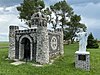 |
November 5, 2001 (#01000686) |
0.5 miles north of the former Chicago and North Western railroad tracks 43°43′33″N 97°41′14″W / 43.725833°N 97.687222°W | Farmer | |
| 6 | |
January 31, 1984 (#84003294) |
Address Restricted | Mitchell |

Former listing[]
| [3] | Name on the Register | Image | Date listed | Date removed | Location | City or town | Description |
|---|---|---|---|---|---|---|---|
| 1 | December 9, 1993 (#93001294) | March 26, 2008 | Local road over Pierre Creek | Fulton |
See also[]
- List of National Historic Landmarks in South Dakota
- National Register of Historic Places listings in South Dakota
References[]
- ^ The latitude and longitude information provided in this table was derived originally from the National Register Information System, which has been found to be fairly accurate for about 99% of listings. Some locations in this table may have been corrected to current GPS standards.
- ^ National Park Service, United States Department of the Interior, "National Register of Historic Places: Weekly List Actions", retrieved February 11, 2022.
- ^ a b Numbers represent an alphabetical ordering by significant words. Various colorings, defined here, differentiate National Historic Landmarks and historic districts from other NRHP buildings, structures, sites or objects.
- ^ "National Register Information System". National Register of Historic Places. National Park Service. April 24, 2008.
- ^ The eight-digit number below each date is the number assigned to each location in the National Register Information System database, which can be viewed by clicking the number.
| Topics |  | |
|---|---|---|
| Lists by county |
| |
| Other lists | ||
| ||
Municipalities and communities of Hanson County, South Dakota, United States | ||
|---|---|---|
| Cities |  | |
| Towns | ||
| CDPs | ||
| Other community | ||
| ||
Categories:
- Hanson County, South Dakota
- Lists of National Register of Historic Places in South Dakota by county
- National Register of Historic Places in Hanson County, South Dakota