[3] Name on the Register[4]
Image
Date listed[5]
Location
City or town
Description
1
Upload image January 3, 1989 (#88003032 ) 604 N. Maple 44°54′30″N 97°06′39″W / 44.908333°N 97.110833°W / 44.908333; -97.110833 (E.C. Adams House ) Watertown
2
Upload image August 4, 2005 (#05000831 ) 15539 444th Ave. 45°08′00″N 97°19′55″W / 45.133333°N 97.331944°W / 45.133333; -97.331944 (Barr Farmstead ) Florence
3
Upload image October 24, 2003 (#03001072 ) 15689 456th Ave. 45°06′33″N 97°05′13″W / 45.109167°N 97.086944°W / 45.109167; -97.086944 (Beskow Barn ) South Shore
4
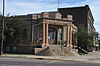
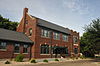
Carnegie Free Public Library
June 18, 1976 (#76001724 ) 27 1st Ave., SE. 44°53′57″N 97°06′47″W / 44.899167°N 97.113056°W / 44.899167; -97.113056 (Carnegie Free Public Library ) Watertown
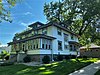
5
Upload image January 3, 1989 (#88003025 ) 803 N. Maple 44°54′37″N 97°06′40″W / 44.910278°N 97.111111°W / 44.910278; -97.111111 (Benjamin H. Cartford House ) Watertown
6
Citizens State Bank of Henry
November 7, 1997 (#97001391 ) Junction of Main and 2nd Sts. 44°52′41″N 97°28′06″W / 44.878056°N 97.468333°W / 44.878056; -97.468333 (Citizens State Bank of Henry ) Henry
7
Codington County Courthouse
July 24, 1978 (#78002545 ) 1st Ave., SE. 44°53′55″N 97°06′51″W / 44.898611°N 97.114167°W / 44.898611; -97.114167 (Codington County Courthouse ) Watertown
8
January 3, 1989 (#88003030 ) 20 4th Ave., NW. 44°54′21″N 97°06′55″W / 44.905833°N 97.115278°W / 44.905833; -97.115278 (Amy A. Davis House ) Watertown
9
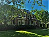
January 3, 1989 (#88003033 ) 603 N. Park 44°54′30″N 97°06′52″W / 44.908333°N 97.114444°W / 44.908333; -97.114444 (Curt E. DeGraff House ) Watertown
10
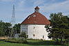
Corson Emminger Round Barn
March 30, 1978 (#78002546 ) South of Watertown on U.S. Route 81 44°51′41″N 97°06′34″W / 44.86128°N 97.10946°W / 44.86128; -97.10946 (Corson Emminger Round Barn ) Watertown Tall round barn built by farmer Corson Emminger during 1909-10, made of concrete blocks with a two-tier roof and a cupola
11
Evangelical United Brethren Church
January 3, 1989 (#88003026 ) 409 N. Maple 44°54′22″N 97°06′41″W / 44.906111°N 97.111389°W / 44.906111; -97.111389 (Evangelical United Brethren Church ) Watertown
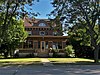
12
January 3, 1989 (#88003034 ) 619 N. Park 44°54′31″N 97°06′52″W / 44.908611°N 97.114444°W / 44.908611; -97.114444 (James W. Ferris House ) Watertown
13
Florence Methodist Church Upload image June 28, 1991 (#91000848 ) Junction of 5th St. and Dolly Ave. 45°03′20″N 97°19′46″W / 45.055556°N 97.329444°W / 45.055556; -97.329444 (Florence Methodist Church ) Florence
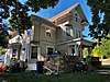
14
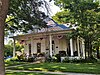
February 9, 2001 (#01000096 ) 316 1st Ave., SE. 44°53′53″N 97°06′34″W / 44.898056°N 97.109444°W / 44.898056; -97.109444 (C.E. and Bertha Fowler House ) Watertown
15
January 3, 1989 (#88003035 ) 501 N. Park 44°54′26″N 97°06′52″W / 44.907222°N 97.114444°W / 44.907222; -97.114444 (Dr. H.M. Freeburg House ) Watertown
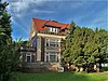
16
A.C. Gilruth House
January 3, 1989 (#88003031 ) 218 2nd Ave., NE. 44°54′14″N 97°06′31″W / 44.903889°N 97.108611°W / 44.903889; -97.108611 (A.C. Gilruth House ) Watertown
17
Goodhue Lutheran Church Upload image July 17, 1996 (#96000745 ) 15555 441st Ave. 45°07′47″N 97°23′33″W / 45.129722°N 97.3925°W / 45.129722; -97.3925 (Goodhue Lutheran Church ) Florence
18
Upload image July 13, 1989 (#89000831 ) 4 miles (6.4 km) north of Henry 44°57′20″N 97°27′06″W / 44.955556°N 97.451667°W / 44.955556; -97.451667 (Nels M. Hanson Farmstead ) Henry
19
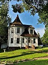
John B. Hanten House
January 26, 1990 (#89002337 ) 518 E. Kemp Ave. 44°53′54″N 97°06′19″W / 44.898333°N 97.105278°W / 44.898333; -97.105278 (John B. Hanten House ) Watertown
20
January 3, 1989 (#88003036 ) 802 1st St., NW. 44°54′37″N 97°06′55″W / 44.910278°N 97.115278°W / 44.910278; -97.115278 (Dr. Harry Henningson House ) Watertown
21
Holy Rosary Church Upload image June 6, 1986 (#86001227 ) Minnesota Ave. 44°53′35″N 96°55′01″W / 44.893056°N 96.916944°W / 44.893056; -96.916944 (Holy Rosary Church ) Kranzburg
22
January 3, 1989 (#88003029 ) 803 1st St., NW. 44°54′37″N 97°06′57″W / 44.910278°N 97.115833°W / 44.910278; -97.115833 (A. Einar Johnson House ) Watertown
23
Upload image November 8, 2001 (#01001221 ) 425 N. Park 44°54′23″N 97°06′51″W / 44.906389°N 97.114167°W / 44.906389; -97.114167 (Mabel and David Jones House ) Watertown
24
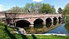
December 9, 1993 (#93001264 ) Kemp Ave. over the Big Sioux River 44°54′10″N 97°07′33″W / 44.90271°N 97.12573°W / 44.90271; -97.12573 (Kemp Avenue Bridge ) Watertown
25
Upload image June 28, 1991 (#91000847 ) Hasting St. 44°53′33″N 96°55′07″W / 44.8925°N 96.918611°W / 44.8925; -96.918611 (Kranzburg School District No. 5 ) Kranzburg
26
February 1, 1982 (#82003923 ) 914 N. Maple 44°54′42″N 97°06′38″W / 44.911667°N 97.110556°W / 44.911667; -97.110556 (Mathiesen House ) Watertown
27
Upload image January 3, 1989 (#88003028 ) 703 N. Maple 44°54′32″N 97°06′41″W / 44.908889°N 97.111389°W / 44.908889; -97.111389 (Peter Mauseth House ) Watertown
28
Upload image July 28, 2011 (#11000485 ) 721 1st. St., NW 44°54′33″N 97°06′56″W / 44.909167°N 97.115556°W / 44.909167; -97.115556 (Andrew and Lulu Melham House ) Watertown North End Neighborhood MPS
29
Mellette House
August 13, 1976 (#76001725 ) 421 5th Ave., NW. 44°54′26″N 97°07′16″W / 44.907222°N 97.121111°W / 44.907222; -97.121111 (Mellette House ) Watertown
30
October 31, 1985 (#85003477 ) 168 N. Broadway 44°54′12″N 97°06′43″W / 44.903333°N 97.111944°W / 44.903333; -97.111944 (Minneapolis and St. Louis Railroad Depot ) Watertown
31
Mount Hope Cemetery Mausoleum
August 13, 1986 (#86001500 ) Mt. Hope Cemetery off U.S. Route 81 44°54′59″N 97°05′56″W / 44.91635°N 97.09899°W / 44.91635; -97.09899 (Mount Hope Cemetery Mausoleum ) Watertown
32
Upload image May 23, 1978 (#78002547 ) North of Watertown off U.S. Route 81 44°56′00″N 97°06′28″W / 44.933333°N 97.107778°W / 44.933333; -97.107778 (Olive Place ) Watertown
33
Upload image October 24, 2003 (#03001075 ) 44350 176th St. 44°50′08″N 97°20′28″W / 44.835556°N 97.341111°W / 44.835556; -97.341111 (Puhlman Farm ) Hazel
34
Upload image October 19, 1989 (#89001726 ) 6 miles (9.7 km) south of Florence 44°58′41″N 97°21′18″W / 44.978056°N 97.355°W / 44.978056; -97.355 (Reeve's Resort ) Florence
35
Upload image February 11, 1988 (#88000047 ) Off Codington County Highway 3 44°51′43″N 96°55′35″W / 44.861944°N 96.926389°W / 44.861944; -96.926389 (Nicholas T. Ries Farmstead ) Kranzburg
36
February 26, 1987 (#87000222 ) 57 4th Ave., NW. 44°54′24″N 97°06′51″W / 44.906667°N 97.114167°W / 44.906667; -97.114167 (Gen. Mark W. Sheafe House ) Watertown
37
Upload image December 9, 1993 (#93001265 ) Local road over an unnamed creek 44°57′11″N 97°03′55″W / 44.953056°N 97.065278°W / 44.953056; -97.065278 (South Dakota Dept. of Transportation Bridge No. 15-210-136 ) Watertown
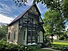
38
Dr. Tarbell House
June 6, 2001 (#01000634 ) 304 2nd Ave., SE. 44°53′49″N 97°06′36″W / 44.896944°N 97.11°W / 44.896944; -97.11 (Dr. Tarbell House ) Watertown
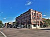
39
Watertown Commercial Historic District
July 13, 1989 (#89000834 ) Roughly bounded by 1st Ave., N., 3rd St., E., 2nd Ave., S., and 1st St., W.; also roughly bounded by 1st St. West, 3rd St. East, 1st Ave. North, 2nd Ave. South 44°54′00″N 97°06′49″W / 44.9°N 97.113611°W / 44.9; -97.113611 (Watertown Commercial Historic District ) Watertown Second set of addresses represent a boundary decrease approved January 29, 2021.
40
Watertown Post Office
December 12, 1976 (#76001726 ) 26 S. Broadway 44°53′58″N 97°06′51″W / 44.899444°N 97.114167°W / 44.899444; -97.114167 (Watertown Post Office ) Watertown
41
Watertown Stadium
July 5, 2000 (#00000721 ) 1600 W. Kemp Ave. 44°54′07″N 97°08′22″W / 44.901958°N 97.139558°W / 44.901958; -97.139558 (Watertown Stadium ) Watertown
42
January 3, 1989 (#88003027 ) 702 2nd St., NE. 44°54′33″N 97°06′33″W / 44.909167°N 97.109167°W / 44.909167; -97.109167 (Walter Willson House ) Watertown
43
Upload image March 31, 2005 (#04001360 ) 16676 456th Ave. 44°58′04″N 97°05′05″W / 44.967778°N 97.084722°W / 44.967778; -97.084722 (Zech Farmstead ) Watertown