From Wikipedia, the free encyclopedia
Location of Lake County in South Dakota
This is a list of the National Register of Historic Places listings in Lake County, South Dakota .
This is intended to be a complete list of the properties and districts on the National Register of Historic Places in Lake County , South Dakota , United States . The locations of National Register properties and districts for which the latitude and longitude coordinates are included below, may be seen in a map.[1]
There are 16 properties and districts listed on the National Register in the county.
This National Park Service list is complete through NPS recent listings posted February 11, 2022. [2]
Current listings [ ]
[3] Name on the Register[4]
Image
Date listed[5]
Location
City or town
Description
1
Chapel Emmanuel Railroad Car
September 8, 1976 (#76001740 ) West of Madison on U.S. Route 81 in Prairie Village 44°00′26″N 97°09′57″W / 44.007222°N 97.165833°W / 44.007222; -97.165833 (Chapel Emmanuel Railroad Car ) Madison
2
Chicago, Milwaukee, St. Paul, and Pacific Railroad Depot
October 19, 1989 (#89001719 ) 315 S. Egan 44°00′10″N 97°06′52″W / 44.002778°N 97.114444°W / 44.002778; -97.114444 (Chicago, Milwaukee, St. Paul, and Pacific Railroad Depot ) Madison
3
Upload image July 13, 1988 (#88000571 ) 102 NE. 9th St. 44°00′55″N 97°06′47″W / 44.015278°N 97.113056°W / 44.015278; -97.113056 (Matthew W. Daly House ) Madison
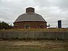
4
J. Whitney Goff Round Barn
May 19, 2004 (#04000469 ) 44520 236th St. 43°57′52″N 97°22′13″W / 43.964444°N 97.370278°W / 43.964444; -97.370278 (J. Whitney Goff Round Barn ) Winfred
5
Upload image January 28, 2004 (#03001526 ) 22808 U.S. Route 81 44°04′43″N 97°07′37″W / 44.078611°N 97.126944°W / 44.078611; -97.126944 (Abraham Hegdahl Farm ) Madison
6
Upload image December 6, 2016 (#16000825 ) 45205 US 81 44°00′27″N 97°08′55″W / 44.007533°N 97.148539°W / 44.007533; -97.148539 (Herschell–Spillman Steam Riding Gallery ) Madison vicinity
7
Upload image June 24, 2003 (#02001428 ) Roughly bounded by U.S. Route 81 and County Roads 16, 37, and 20 44°09′17″N 97°06′00″W / 44.154722°N 97.1°W / 44.154722; -97.1 (Lake Badus Rural Agricultural Historic District ) Nunda
8
Lake County Courthouse
February 10, 1993 (#92001861 ) Center St. between Harth and Lee Aves. 44°00′20″N 97°06′41″W / 44.005556°N 97.111389°W / 44.005556; -97.111389 (Lake County Courthouse ) Madison
9
Lake Madison Lutheran Church Upload image October 12, 2000 (#00001220 ) 5.5 miles southeast of Madison 44°04′51″N 97°02′37″W / 44.080833°N 97.043611°W / 44.080833; -97.043611 (Lake Madison Lutheran Church ) Madison
10
January 30, 1978 (#78002561 ) Lake Herman State Park 43°59′29″N 97°09′57″W / 43.991389°N 97.165833°W / 43.991389; -97.165833 (Herman Luce Cabin ) Madison
11
Upload image June 3, 1976 (#76001741 ) 304 NE. 4th St. 44°00′34″N 97°06′37″W / 44.009444°N 97.110278°W / 44.009444; -97.110278 (William A. Mackay House ) Madison
12
Upload image May 11, 1976 (#76001742 ) Bounded roughly by both sides of Egan Ave., Washington, and 4th and 7th Sts. 44°00′39″N 97°06′43″W / 44.010833°N 97.111944°W / 44.010833; -97.111944 (Madison Historic District ) Madison
13
Madison Masonic Temple Upload image January 26, 1990 (#89002335 ) 229 N. Egan Ave. 44°00′25″N 97°06′48″W / 44.006944°N 97.113333°W / 44.006944; -97.113333 (Madison Masonic Temple ) Madison
14
St. Ann's Catholic Church of Badus Upload image August 7, 1979 (#79002403 ) Northeast of Ramona 44°08′51″N 97°08′28″W / 44.1475°N 97.141111°W / 44.1475; -97.141111 (St. Ann's Catholic Church of Badus ) Ramona
15
Upload image February 12, 1999 (#99000203 ) 3rd St. 44°07′07″N 97°13′01″W / 44.118611°N 97.216944°W / 44.118611; -97.216944 (St. William's Catholic Church ) Ramona
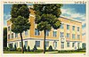
16
Upload image June 28, 2010 (#10000411 ) 514 North Washington 44°07′07″N 97°13′01″W / 44.118611°N 97.216944°W / 44.118611; -97.216944 (Washington School ) Madison 1924 building representative of school design of 1920s South Dakota[6]
See also [ ] References [ ]
^ The latitude and longitude information provided in this table was derived originally from the National Register Information System, which has been found to be fairly accurate for about 99% of listings. Some locations in this table may have been corrected to current GPS standards.
^ National Park Service, United States Department of the Interior , "National Register of Historic Places: Weekly List Actions" , retrieved February 11, 2022.
^ Numbers represent an alphabetical ordering by significant words. Various colorings, defined here , differentiate National Historic Landmarks and historic districts from other NRHP buildings, structures, sites or objects.
^ "National Register Information System" . National Register of Historic Places National Park Service . April 24, 2008.^ The eight-digit number below each date is the number assigned to each location in the National Register Information System database, which can be viewed by clicking the number.
^ "Washington School on National Register" . Daily Leader . Madison, South Dakota. Associated Press . August 30, 2010. Archived from the original on September 19, 2012. Retrieved September 2, 2010 .
Topics Lists by Other lists
Category List National Register of Historic Places Portal
Categories :
Lake County, South Dakota Lists of National Register of Historic Places in South Dakota by county Buildings and structures in Lake County, South Dakota National Register of Historic Places in Lake County, South Dakota Hidden categories:
Articles using NRISref without a reference number Lists of coordinates Geographic coordinate lists Articles with Geo Commons category link is on Wikidata