[3] Name on the Register[4]
Image
Date listed[5]
Location
City or town
Description
1
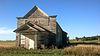
Anderson Homestead Upload image March 30, 1978 (#78002543 ) East of Hub City 42°57′45″N 96°48′23″W / 42.9625°N 96.806389°W / 42.9625; -96.806389 (Anderson Homestead ) Hub City
2
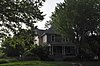
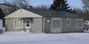
William Andre House
October 31, 2002 (#02001284 ) 31256 452nd Ave. 42°51′29″N 97°09′35″W / 42.858175°N 97.159770°W / 42.858175; -97.159770 (William Andre House ) Gayville
3
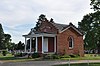
Austin-Whittemore House
October 18, 1972 (#72001225 ) 15 Austin Ave. 42°46′44″N 96°56′07″W / 42.7789°N 96.9353°W / 42.7789; -96.9353 (Austin-Whittemore House ) Vermillion Now a local history museum.
4
Upload image June 23, 2016 (#16000415 ) Oak Pl. and Court, Kidder, Church, and Bloomingdale Sts. 42°46′38″N 96°55′54″W / 42.777222°N 96.931667°W / 42.777222; -96.931667 (Bluff Historic District ) Vermillion
5
Bluff View Cemetery Chapel
May 31, 2006 (#06000458 ) 0.2 miles south of junction of Crawford Rd. and Pinehurst Dr. 42°46′25″N 96°54′20″W / 42.7736°N 96.9056°W / 42.7736; -96.9056 (Bluff View Cemetery Chapel ) Vermillion
6
Building at 125 Ohio St.
February 14, 2002 (#02000021 ) 125 Ohio St. 43°00′31″N 97°06′25″W / 43.008591°N 97.106847°W / 43.008591; -97.106847 (Building at 125 Ohio St. ) Wakonda
7
July 5, 1996 (#96000740 ) White St., 2 blocks north of the former Chicago, Milwaukee, St. Paul and Pacific railroad tracks. 42°44′53″N 96°49′41″W / 42.7481°N 96.8281°W / 42.7481; -96.8281 (Burbank School No. 10 ) Burbank
8
Clay County Courthouse
August 18, 1983 (#83003005 ) 211 W. Main St. 42°46′47″N 96°56′08″W / 42.7797°N 96.9356°W / 42.7797; -96.9356 (Clay County Courthouse ) Vermillion
9
November 19, 2007 (#07001210 ) 402 S. University St. 42°46′37″N 96°55′26″W / 42.7769°N 96.9239°W / 42.7769; -96.9239 (Colton House ) Vermillion
10
Downtown Vermillion Historic District
March 7, 2003 (#02001288 ) Main St., roughly bounded by Market and Dakota Sts. 42°46′45″N 96°55′52″W / 42.7792°N 96.9311°W / 42.7792; -96.9311 (Downtown Vermillion Historic District ) Vermillion
11
First Baptist Church of Vermillion
March 5, 1982 (#82003921 ) 101 E. Main St. 42°46′44″N 96°55′49″W / 42.7789°N 96.9303°W / 42.7789; -96.9303 (First Baptist Church of Vermillion ) Vermillion
12
Upload image July 16, 2021 (#100006723 ) 226 East Main St. 42°46′46″N 96°55′40″W / 42.7794°N 96.9279°W / 42.7794; -96.9279 (First Congregational Church, Vermillion ) Vermillion
13
First Methodist Episcopal Church
January 28, 2004 (#03001522 ) 14-16 North Dakota St. 42°46′46″N 96°55′46″W / 42.7794°N 96.9294°W / 42.7794; -96.9294 (First Methodist Episcopal Church ) Vermillion
14
First National Bank Building of Vermillion
February 13, 1986 (#86000244 ) 1 E. Main St. 42°46′45″N 96°55′54″W / 42.7792°N 96.9317°W / 42.7792; -96.9317 (First National Bank Building of Vermillion ) Vermillion
15
October 18, 1979 (#79002400 ) Forest Ave. and Lewis St.March 6, 2012 , refnum 12000086): 15-322 Forest Ave., 205-221 Lewis St. 42°46′36″N 96°55′43″W / 42.7767°N 96.9286°W / 42.7767; -96.9286 (Forest Avenue Historic District ) Vermillion
16
Garfield Township Hall
January 28, 2004 (#03001523 ) 16667 306th St. 42°57′08″N 96°51′50″W / 42.952222°N 96.863889°W / 42.952222; -96.863889 (Garfield Township Hall ) Beresford
17
Gunderson House
February 9, 2001 (#01000092 ) 24 S. Harvard 42°46′38″N 96°55′39″W / 42.7772°N 96.9275°W / 42.7772; -96.9275 (Gunderson House ) Vermillion
18
Inman House
May 24, 1976 (#76001723 ) 415 E. Main St. 42°46′45″N 96°55′31″W / 42.7792°N 96.9253°W / 42.7792; -96.9253 (Inman House ) Vermillion
19
December 17, 1999 (#99001581 ) 31494 453rd Ave. 42°49′26″N 97°08′24″W / 42.823815°N 97.139907°W / 42.823815; -97.139907 (Calle Nissen Johnsen Farm ) Gayville
20
December 20, 1988 (#88002841 ) Norway Township, Section 6 42°48′46″N 97°08′57″W / 42.812778°N 97.149167°W / 42.812778; -97.149167 (Jens N. and Anna Junker Farmstead )
21
August 16, 2000 (#00000995 ) 45352 Timber Rd. 42°47′39″N 97°07′50″W / 42.794104°N 97.130586°W / 42.794104; -97.130586 (Lincoln School No. 12 ) Meckling
22
Linden House
September 14, 2001 (#01001001 ) 509 Linden Ave. 42°46′26″N 96°55′24″W / 42.7739°N 96.9233°W / 42.7739; -96.9233 (Linden House ) Vermillion
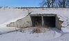
23
Upload image February 14, 2002 (#02000022 ) 30337 Greenfield Rd. 42°59′36″N 96°50′59″W / 42.993333°N 96.849722°W / 42.993333; -96.849722 (Daniel A. Messler Homestead ) Beresford
24
Old Armory-Vermillion
October 31, 2002 (#02001285 ) 414 E. Clark St. 42°47′03″N 96°55′31″W / 42.784186°N 96.925224°W / 42.784186; -96.925224 (Old Armory-Vermillion ) Vermillion Now the Belbas Center on the campus of the University of South Dakota .
25
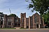
Old Main
March 24, 1973 (#73001738 ) Clark St. on the University of South Dakota campus 42°47′02″N 96°55′26″W / 42.7839°N 96.9239°W / 42.7839; -96.9239 (Old Main ) Vermillion
26
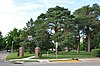
Prentis Park
November 8, 2001 (#01001218 ) Plum and Main Sts. 42°46′53″N 96°55′05″W / 42.7814°N 96.9181°W / 42.7814; -96.9181 (Prentis Park ) Vermillion
27
Upload image January 20, 1978 (#78002544 ) West of Vermillion 42°53′47″N 97°01′11″W / 42.896389°N 97.019722°W / 42.896389; -97.019722 (Rice Farm ) Vermillion
28
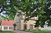
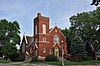
St. Agnes Catholic Church
March 27, 1995 (#95000280 ) 202 Washington St. 42°46′54″N 96°56′04″W / 42.7817°N 96.9344°W / 42.7817; -96.9344 (St. Agnes Catholic Church ) Vermillion Now an arts center.
29
Sample-Lindblaum House
December 2, 1998 (#98001405 ) 410 Idaho St. 43°00′15″N 97°06′29″W / 43.004062°N 97.108065°W / 43.004062; -97.108065 (Sample-Lindblaum House ) Wakonda
30
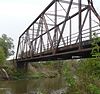
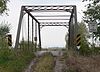
November 8, 2001 (#01001220 ) Local road over the Vermillion River 42°49′47″N 96°54′16″W / 42.829703°N 96.904550°W / 42.829703; -96.904550 (South Dakota Department of Trans. Br. No. 14-130-176 ) Vermillion
31
November 8, 2001 (#01001222 ) Local road over the Vermillion River 42°50′14″N 96°53′44″W / 42.837295°N 96.895637°W / 42.837295; -96.895637 (South Dakota Department of Trans. Br. No. 14-133-170 ) Vermillion
32
January 28, 2000 (#00000020 ) Local road over Spring Creek 43°02′19″N 97°02′32″W / 43.038497°N 97.042220°W / 43.038497; -97.042220 (South Dakota Department of Transportation Bridge No. 14-060-032 ) Wakonda Apparently no longer extant[6]
33
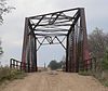
January 14, 2000 (#99001689 ) Local road over Clay Creek Ditch 42°50′14″N 96°59′19″W / 42.837289°N 96.988497°W / 42.837289; -96.988497 (South Dakota Department of Transportation Bridge No. 14-088-170 ) Vermillion
34
Upload image January 14, 2000 (#99001700 ) Local road over the Vermillion River 43°01′23″N 96°58′58″W / 43.0229804°N 96.9827101°W / 43.0229804; -96.9827101 (South Dakota Department of Transportation Bridge No. 14-090-042 ) Wakonda
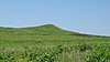
35
Spirit Mound
November 19, 1974 (#74001889 ) North of Vermillion 42°52′32″N 96°57′32″W / 42.8756°N 96.9589°W / 42.8756; -96.9589 (Spirit Mound ) Vermillion
36
February 24, 1975 (#75001714 ) Bounded by N. Yale, E. Clark, Willow, and E. Main Sts. 42°46′52″N 96°55′27″W / 42.7811°N 96.9242°W / 42.7811; -96.9242 (University Historic District ) Vermillion Named "Vermillion Historic District" until September 1, 2015
37
August 18, 1983 (#83003006 ) 12 Church St. 42°46′43″N 96°55′49″W / 42.7786°N 96.9303°W / 42.7786; -96.9303 (Vermillion-Andrew Carnegie Library ) Vermillion
38
Wakonda State Bank
August 15, 2003 (#03000765 ) 118 Ohio St. 43°00′31″N 97°06′26″W / 43.008499°N 97.107291°W / 43.008499; -97.107291 (Wakonda State Bank ) Wakonda
39
June 17, 1982 (#82003922 ) 104 Court St. 42°46′41″N 96°55′54″W / 42.7781°N 96.9317°W / 42.7781; -96.9317 (E.H. Willey House ) Vermillion
40
Upload image January 23, 2007 (#06001310 ) 30831 Highway 19 42°55′20″N 96°57′17″W / 42.922222°N 96.954722°W / 42.922222; -96.954722 (Yusten House ) Vermillion