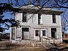
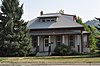
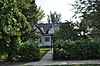
[3] Name on the Register[4]
Image
Date listed[5]
Location
City or town
Description
1
October 25, 1990 (#90001646 ) 340 Kansas 44°29′35″N 103°51′18″W / 44.493056°N 103.855°W / 44.493056; -103.855 (Oliver N. Ainsworth House ) Spearfish part of the Architecture of Finnish Settlement Thematic Resource (TR)
2
Upload image January 16, 2015 (#14001179 ) 11753 Anderson Rd. 44°30′39″N 103°41′45″W / 44.5108°N 103.6958°W / 44.5108; -103.6958 (Rasmus and Elemine Anderson Homestead Ranch ) St. Onge vicinity
3
October 24, 1996 (#96001231 ) 740 8th St. 44°29′29″N 103°51′19″W / 44.491389°N 103.855278°W / 44.491389; -103.855278 (Baker Bungalow ) Spearfish
4
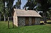
Upload image November 13, 1985 (#85003488 ) FDR 206 44°12′27″N 103°48′11″W / 44.2075°N 103.803056°W / 44.2075; -103.803056 (Henry Buskala Ranch ) part of the Architecture of Finnish Settlement TR
5
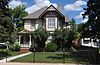
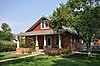
July 13, 1988 (#88000573 ) 840 8th Ave. 44°29′33″N 103°51′20″W / 44.4925°N 103.855556°W / 44.4925; -103.855556 (Fayette Cook House ) Spearfish
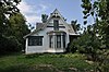
6
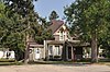
James A. Corbin House
October 25, 1990 (#90001651 ) 345 Main St. 44°29′11″N 103°51′28″W / 44.486389°N 103.857778°W / 44.486389; -103.857778 (James A. Corbin House ) Spearfish
7
October 25, 1990 (#90001652 ) 329 Main St. 44°29′10″N 103°51′28″W / 44.486111°N 103.857778°W / 44.486111; -103.857778 (Henry Court House ) Spearfish
8
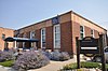
Upload image June 8, 2005 (#05000592 ) 20896 Fillmore Mine Ln. 44°22′23″N 104°02′02″W / 44.373056°N 104.033889°W / 44.373056; -104.033889 (Dakota Tin and Gold Mine ) Spearfish
9
Deadwood Historic District
October 15, 1966 (#66000716 ) Bounded by the city limits 44°22′19″N 103°44′00″W / 44.371944°N 103.733333°W / 44.371944; -103.733333 (Deadwood Historic District ) Deadwood
10
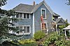
July 13, 1989 (#89000824 ) 735 8th St. 44°29′28″N 103°51′21″W / 44.491111°N 103.855833°W / 44.491111; -103.855833 (Eleazer C. and Gwinnie Dickey House ) Spearfish
11
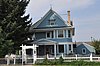
May 16, 1988 (#88000568 ) 815 State St. 44°29′31″N 103°51′17″W / 44.491944°N 103.854722°W / 44.491944; -103.854722 (Walter Dickey House ) Spearfish
12
July 13, 1989 (#89000822 ) 335 Canyon St. 44°29′10″N 103°51′39″W / 44.486111°N 103.860833°W / 44.486111; -103.860833 (William D. Driskill House ) Spearfish
13
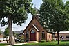
Episcopal Church of All Angels
April 22, 1976 (#76001743 ) 129 W. Michigan 44°29′38″N 103°51′38″W / 44.493889°N 103.860556°W / 44.493889; -103.860556 (Episcopal Church of All Angels ) Spearfish
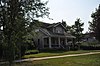
14
Frawley Historic Ranch
December 31, 1974 (#74001893 ) 6 miles (9.7 km) east of Spearfish on U.S. Route 14 44°28′30″N 103°42′38″W / 44.475°N 103.710556°W / 44.475; -103.710556 (Frawley Historic Ranch ) Spearfish
15
Upload image November 30, 1999 (#99001435 ) Block 13, Lots 1-5 Bryan Placer No. 913 44°19′42″N 103°38′47″W / 44.328333°N 103.646389°W / 44.328333; -103.646389 (Galena School ) Galena part of the Schools in South Dakota Multiple Property Submission (MPS)
16
December 12, 1976 (#76001744 ) 214 E. Jackson St. 44°29′30″N 103°51′26″W / 44.491667°N 103.857222°W / 44.491667; -103.857222 (Halloran-Matthews-Brady House ) Spearfish
17
Upload image March 14, 2019 (#100003444 ) 21732 Hann Pl. 44°15′07″N 103°39′44″W / 44.2520°N 103.6621°W / 44.2520; -103.6621 (Solomon and Martha Hann Homestead ) Nemo vicinity
18
Upload image October 18, 2011 (#11000746 ) 22107 US 85 44°11′54″N 104°02′14″W / 44.198316°N 104.037155°W / 44.198316; -104.037155 (Hardy Guard Station ) Lead
19
Upload image September 12, 2008 (#08000885 ) Township 3, Range 2, Track A of Homestead Entry Survey 71 44°11′59″N 103°49′10″W / 44.199722°N 103.819444°W / 44.199722; -103.819444 (Jerome and Jonetta Harvey Homestead Cabin ) Lead
20
Arthur Hewes House
October 25, 1990 (#90001650 ) 811 St. Joe 44°29′29″N 103°52′07″W / 44.491389°N 103.868611°W / 44.491389; -103.868611 (Arthur Hewes House ) Spearfish
21
John Hill Ranch-Keltomaki Upload image November 13, 1985 (#85003489 ) Northeast of Brownsville 44°17′11″N 103°39′11″W / 44.286389°N 103.653056°W / 44.286389; -103.653056 (John Hill Ranch-Keltomaki ) Brownsville part of the Architecture of Finnish Settlement TR
22
November 1, 1991 (#91001620 ) 830 State St. 44°29′32″N 103°51′15″W / 44.492222°N 103.854167°W / 44.492222; -103.854167 (Homestake Workers House ) Spearfish
23
Upload image March 11, 2019 (#100003440 ) Several blks. around E. Jackson Blvd., generally bounded by N. 7th, N. 10th, E. Kansas & E. Hudson Sts. 44°29′30″N 103°51′20″W / 44.4917°N 103.8556°W / 44.4917; -103.8556 (Jackson Boulevard Historic District ) Spearfish
24
July 13, 1988 (#88000572 ) 344 E. Illinois 44°29′27″N 103°51′16″W / 44.490833°N 103.854444°W / 44.490833; -103.854444 (Henry Keets House ) Spearfish
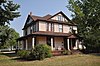
25
Webb S. Knight House
July 13, 1989 (#89000823 ) 514 7th St. 44°29′19″N 103°51′22″W / 44.488611°N 103.856111°W / 44.488611; -103.856111 (Webb S. Knight House ) Spearfish
26
May 20, 1988 (#88000576 ) Spearfish city park 44°29′06″N 103°51′38″W / 44.485°N 103.860556°W / 44.485; -103.860556 (Kroll Meat Market and Slaughterhouse ) Spearfish
27
Lead Historic District
December 31, 1974 (#74001892 ) Roughly bounded by the city limits 44°21′06″N 103°45′45″W / 44.351667°N 103.7625°W / 44.351667; -103.7625 (Lead Historic District ) Lead
28
May 28, 1976 (#76001745 ) 745 5th St. 44°29′26″N 103°51′38″W / 44.490556°N 103.860556°W / 44.490556; -103.860556 (William Ernest Lown House ) Spearfish
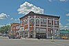
29
May 16, 1988 (#88000574 ) 731 Main St. 44°29′26″N 103°51′32″W / 44.490556°N 103.858889°W / 44.490556; -103.858889 (The Mail Building ) Spearfish
30
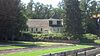
Upload image February 14, 2002 (#02000025 ) 410 N. Rainbow Rd. 44°28′46″N 103°46′06″W / 44.479444°N 103.768333°W / 44.479444; -103.768333 (McLaughlin Ranch Barn ) Spearfish
31
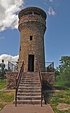
Mount Theodore Roosevelt Monument
December 22, 2005 (#05001457 ) Black Hills National Forest 44°23′53″N 103°45′33″W / 44.398056°N 103.759167°W / 44.398056; -103.759167 (Mount Theodore Roosevelt Monument ) Deadwood
32
July 17, 1996 (#96000747 ) 12743 Nemo Rd.[6] 44°13′29″N 103°34′38″W / 44.224764°N 103.577175°W / 44.224764; -103.577175 (Nemo School House ) Nemo
33
Old Finnish Lutheran Church
November 13, 1985 (#85003487 ) Sinking Gardens, E. Main St. 44°21′09″N 103°45′50″W / 44.3525°N 103.763889°W / 44.3525; -103.763889 (Old Finnish Lutheran Church ) Lead part of the Architecture of Finnish Settlement TR
34
November 1, 1991 (#91001618 ) W. Center St. 44°32′49″N 103°43′23″W / 44.546944°N 103.723056°W / 44.546944; -103.723056 (Thomas Quillian House ) Saint Onge
35
Old Redwater Bridge Upload image December 9, 1993 (#93001300 ) Local road over the Redwater River 44°35′24″N 103°51′22″W / 44.59°N 103.856111°W / 44.59; -103.856111 (Old Redwater Bridge ) Spearfish part of the Historic Bridges in South Dakota MPS
36
Upload image August 14, 2012 (#12000514 ) 0.33 miles (0.53 km) southeast of the junction of Radio Rd. & US 14 44°23′00″N 103°39′43″W / 44.383241°N 103.661961°W / 44.383241; -103.661961 (Pearson Cabin ) Deadwood vicinity
37
July 13, 1989 (#89000825 ) 938 Ames 44°29′35″N 103°52′04″W / 44.493056°N 103.867778°W / 44.493056; -103.867778 (Almira Riley House ) Spearfish
38
St. Lawrence O'Toole Catholic Church
February 5, 2003 (#02001764 ) 618 Main 44°22′10″N 103°45′58″W / 44.369444°N 103.766111°W / 44.369444; -103.766111 (St. Lawrence O'Toole Catholic Church ) Central City
39
May 7, 1980 (#80003727 ) Off Highway 24 44°32′47″N 103°43′26″W / 44.546389°N 103.723889°W / 44.546389; -103.723889 (St. Onge Schoolhouse ) Saint Onge
40
October 26, 2005 (#05001190 ) 214 Center St. 44°32′56″N 103°43′14″W / 44.548889°N 103.720556°W / 44.548889; -103.720556 (Saint Onge State Bank ) Saint Onge
41
October 25, 1990 (#90001649 ) 722 Main St. 44°29′27″N 103°51′31″W / 44.490833°N 103.858611°W / 44.490833; -103.858611 (Spearfish City Hall ) Spearfish
42
Spearfish Filling Station
May 16, 1988 (#88000567 ) 706 Main St. 44°29′25″N 103°51′30″W / 44.490278°N 103.858333°W / 44.490278; -103.858333 (Spearfish Filling Station ) Spearfish
43
Spearfish Fisheries Center
May 19, 1978 (#78003438 ) South of Spearfish off U.S. Route 14 44°28′52″N 103°51′36″W / 44.481111°N 103.86°W / 44.481111; -103.86 (Spearfish Fisheries Center ) Spearfish
44
June 5, 1975 (#75001718 ) 544, 545, 603-645 Main St., 114-136 W. Illinois St., and 701-703 5th St. 44°29′22″N 103°51′32″W / 44.489444°N 103.858889°W / 44.489444; -103.858889 (Spearfish Historic Commercial District ) Spearfish Boundary decrease approved November 2, 2017.
45
January 20, 2015 (#14001180 ) Mi. 1, I-90 44°32′42″N 104°02′03″W / 44.545089°N 104.034236°W / 44.545089; -104.034236 (Spearfish Rest Stop Tipi ) Spearfish vicinity
46
February 12, 1999 (#99000205 ) 526 Main St. 44°29′19″N 103°51′30″W / 44.4885°N 103.858333°W / 44.4885; -103.858333 (Old Spearfish Post Office ) Spearfish part of the Federal Relief Construction in South Dakota MPS
47
Tomahawk Lake Country Club
October 26, 2005 (#05001191 ) U.S. Route 385 44°17′27″N 103°41′07″W / 44.290833°N 103.685278°W / 44.290833; -103.685278 (Tomahawk Lake Country Club ) Deadwood
48
November 7, 1997 (#97001390 ) 1011 Main St. 44°29′36″N 103°51′35″W / 44.493333°N 103.859722°W / 44.493333; -103.859722 (Toomey House ) Spearfish
49
July 13, 1989 (#89000827 ) 230 Jackson 44°29′30″N 103°51′23″W / 44.491667°N 103.856389°W / 44.491667; -103.856389 (Otto L. Uhlig House ) Spearfish
50
Walsh Barn Upload image May 30, 2003 (#03000500 ) 0.5 miles (0.80 km) west of the junction of Upper Redwater Rd. and 104th Ave. 44°34′47″N 103°59′19″W / 44.579722°N 103.988611°W / 44.579722; -103.988611 (Walsh Barn ) Spearfish
51
May 30, 2005 (#05000036 ) 221 Upper Valley Rd. 44°30′38″N 103°52′50″W / 44.510556°N 103.880556°W / 44.510556; -103.880556 (Walton Ranch ) Spearfish
52
Upload image June 8, 2007 (#07000529 ) 1005-1021 Meade St. 44°27′46″N 103°38′23″W / 44.462778°N 103.639722°W / 44.462778; -103.639722 (Whitewood Historic District ) Whitewood
53
October 25, 1990 (#90001647 ) 704 8th St. 44°29′27″N 103°51′19″W / 44.490833°N 103.855278°W / 44.490833; -103.855278 (Mary Whitney House ) Spearfish
54
July 13, 1988 (#88000562 ) 814 8th Ave. 44°29′31″N 103°51′20″W / 44.491944°N 103.855556°W / 44.491944; -103.855556 (John Wolzmuth House ) Spearfish
55
Woodmen Hall
November 14, 1991 (#91001619 ) Junction of Center and 2nd Sts. 44°32′49″N 103°43′12″W / 44.546944°N 103.72°W / 44.546944; -103.72 (Woodmen Hall ) Saint Onge