Nooken District
Nooken
نووقەن رايونۇ | |
|---|---|
 | |
| Country | Kyrgyzstan |
| Region | Jalal-Abad Region |
| Area | |
| • Total | 2,336 km2 (902 sq mi) |
| Population (2021) | |
| • Total | 145,187 |
| • Density | 62/km2 (160/sq mi) |
| Time zone | UTC+6 (Kyrgyzstan Time) |
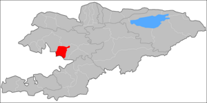
Nooken District (Kyrgyz: Ноокен району, نووقەن رايونۇ, before 1992: Lenin District)[1] is a district of Jalal-Abad Region in western Kyrgyzstan. The administrative seat lies at Masy.[2] Its area is 2,336 square kilometres (902 sq mi),[1] and its resident population was 145,187 in 2021.[3]
Population[]
| Year | Pop. | ±% p.a. |
|---|---|---|
| 1970 | 54,296 | — |
| 1979 | 63,858 | +1.82% |
| 1989 | 81,515 | +2.47% |
| 1999 | 101,519 | +2.22% |
| 2009 | 117,055 | +1.43% |
| 2021 | 145,187 | +1.81% |
| Note: resident population; Sources:[1][3] | ||
Towns, rural communities and villages[]
In total, Nooken District includes 1 town and 54 settlements in 8 rural communities (ayyl aymagy). Each rural community can consist of one or several villages. The rural communities and settlements in the Nooken District are:[2][4]
- town Kochkor-Ata
- Aral (seat: Aral; incl. Internatsional, Rassvet, Chertak-Tash and Cheremushki)
- Bürgöndü (seat: Bürgöndü; incl. Jangy-Aryk, Jengish, Kichi-Bürgöndü, Kokonduk, Kurama, Kyzyl-Kyya, Nooshken and Uuru-Jar)
- Dostuk (seat: Shamaldy-Say; incl. Dostuk, Kuduk, Kyzyl-Tuu, Sary-Kamysh and Shyng-Say)
- Masy (seat: Masy; incl. Apyrtan, Besh-Jygach, Bögöt and Kyzyl-Tuu)
- Mombekov (seat: Mombekov; incl. Boston, Jazgak, Jangy-Kyshtak, Kök-Tash, Kochkor-Ata, Kurulush and Chek)
- Nookat (seat: Kurulush; incl. Kara-Bulak, Kirov, Komintern, Kyzyl-Jyldyz, Parakanda and Rakhmanjan)
- Sakaldy (seat: Sakaldy; incl. Arimjan, Böbüy, Kagazdy, Kyzyl-Kyrgyzstan, Chek and Chong-Bagysh)
- Shaydan (seat: Alma; incl. Birdik, Jangy-Aryk, Jon-Aryk, Kök-Ajdar, Toskool and Eski-Masy)
References[]
- ^ a b c "2009 population and housing census of the Kyrgyz Republic: Jalal-Abad Region" (PDF) (in Russian). National Statistics Committee of the Kyrgyz Republic. 2010. pp. 13, 17, 338.
- ^ a b "Classification system of territorial units of the Kyrgyz Republic" (in Kyrgyz). National Statistics Committee of the Kyrgyz Republic. May 2021. pp. 22–24.
- ^ a b "Population of regions, districts, towns, urban-type settlements, rural communities and villages of Kyrgyz Republic" (XLS) (in Russian). National Statistics Committee of the Kyrgyz Republic. 2021. Archived from the original on 10 November 2021.
- ^ "Rural districts". Archived from the original on 2010-02-09. Retrieved 2010-03-14.
| North Kyrgyzstan |
|  | ||||||||||
|---|---|---|---|---|---|---|---|---|---|---|---|---|
| South Kyrgyzstan |
| |||||||||||
Coordinates: 41°03′43″N 72°37′56″E / 41.0620°N 72.6321°E

This Jalal-Abad region location article is a stub. You can help Wikipedia by . |
Categories:
- Districts of Jalal-Abad Region
- Jalal-Abad geography stubs