Panfilov District, Kyrgyzstan
Panfilov | |
|---|---|
Raion | |
 | |
| Country | Kyrgyzstan |
| Province | Chuy Region |
| Area | |
| • Total | 2,606 km2 (1,006 sq mi) |
| Population (2009)[1] | |
| • Total | 41,754 |
| • Density | 16/km2 (41/sq mi) |
| Time zone | UTC+5 (GMT +5) |
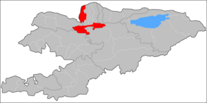
Panfilov is a raion (district) of Chuy Region in northern Kyrgyzstan. Its area is 2,606 square kilometres (1,006 sq mi), and its resident population was 41,754 in 2009.[1] The capital lies at Kayyngdy (Kaindy). The district covers the westernmost part of the Chuy Region, and a mountainous exclave separated from the rest of the Panfilov District by the Jayyl District.[2][1]
Rural communities and villages[]
In total, Panfilov District includes 1 city and 20 settlements in 6 rural communities (aiyl okmotus). Each rural community includes one or several villages. The rural communities and settlements in the Panfilov District are as follows:[3][4][5]
- city Kaindy (town of district significance)
- Voznesenovka aiyl okmotu (3: center - village: Voznesenovka; and also villages Orto-Kayyrma and Erkin-Say)
- Kürpüldök aiyl okmotu (3: center - village: Kürpüldök; and also villages Imeni Kirova and Rovnoye)
- Ortoev aiyl okmotu (3: center - village: Imeni Telmana; and also villages Bukara and Kum-Aryk)
- Kurama aiyl okmotu (4: center - village: Panfilovskoye; and also villages Jayylma, Orto-Aryk and Efironos)
- Frunze aiyl okmotu (3: center - village: Chaldybar; and also villages Cholok-Aryk and Chorgolu)
- Chaldybar aiyl okmotu (4: center - village: Pervomayskoye; and also villages Ozernoye, Oktyabrskoye and Oyrondu)

Voznesenovka
Orto-Kayyrma
Erkin-Say
Kürpüldök
Imeni Kirova
Imeni Telmana
Bukara
Kum-Aryk
Panfilovskoye
Jayylma
Orto-Aryk
Efironos
Cholok-Aryk
Chorgolu
Ozernoye
Oktyabrskoye
Oyrondu
References[]
- ^ Jump up to: a b c "2009 population census of the Kyrgyz Republic: Chuy Region" (PDF). Archived from the original (PDF) on 10 August 2011. Retrieved 2011-08-10.
- ^ Enrin.grida.no
- ^ List of Rural Communities of Kyrgyzstan Archived 2010-02-09 at the Wayback Machine
- ^ 2012 Law on the transformation of individual urban settlements of the Kyrgyz Republic and relating them to the category of village or city
- ^ State classification on objects of administrative and territorial units, 2020-06-11 (in Russian)
| hide | ||||||||||||
|---|---|---|---|---|---|---|---|---|---|---|---|---|
| North Kyrgyzstan |
|  | ||||||||||
| South Kyrgyzstan |
| |||||||||||
Coordinates: 42°49′N 73°40′E / 42.817°N 73.667°E

Categories:
- Districts of Chuy Region
- Chuy geography stubs