Özgön District
Özgön
Өзгөн району Uzgen | |
|---|---|
 Flag  Coat of arms | |
 | |
| Country | Kyrgyzstan |
| Region | Osh Region |
| Area | |
| • Total | 3,308 km2 (1,277 sq mi) |
| Population (2021)[1] | |
| • Total | 282,981 |
| • Density | 86/km2 (220/sq mi) |
| Time zone | UTC+6 (KGT) |
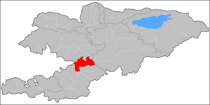
Özgön or Uzgen (Kyrgyz: Өзгөн району) is a district of Osh Region in south-western Kyrgyzstan. Its area is 3,308 square kilometres (1,277 sq mi),[2] and its resident population was 282,981 in 2021.[1]> The capital lies at Özgön (Uzgen).[3]
Demographics[]
As of 2009, Özgön District included 1 town, and 19 villages. Its population, according to the Population and Housing Census of 2009, was 228,114. Of them, 49,410 people live in urban areas, and 178,704 in rural ones.
| Year | Pop. | ±% p.a. |
|---|---|---|
| 1970 | 102,024 | — |
| 1979 | 120,980 | +1.91% |
| 1989 | 151,806 | +2.30% |
| 1999 | 193,766 | +2.47% |
| 2009 | 228,114 | +1.65% |
| 2021 | 282,981 | +1.81% |
| Note: resident population; Sources:[2][1] | ||
Ethnic composition[]
According to the 2009 Census, the ethnic composition of the Özgön District (de jure population) was:[2]
| Ethnic group | Population | Proportion of Özgön District population |
|---|---|---|
| Kyrgyzs | 168,277 | 73.8% |
| Uzbeks | 50,666 | 22.2% |
| Turks | 7,210 | 3.1% |
| Russians | 707 | 0.3% |
| Uygurs | 595 | 0.3% |
| Tatars | 254 | 0.1% |
| Tadjiks | 124 | 0.1% |
| other groups | 281 | 0.1% |
Towns, rural communities and villages[]

In total, Özgön District include 1 town and 99 settlements in 19 rural communities (ayyl aymagy). Each rural community can consist of one or several villages. The rural communities and settlements in the Özgön District are:[3][4]
- town Özgön
- Ak-Jar (seat: Ak-Jar; incl. Kakyr, Semiz-Köl and Bolshevik)
- Altyn-Bulak (seat: Altyn-Bulak; incl. Chechebay, Tash-Bashat, Sasyk-Bulak, Kara-Batkak and Kandava)
- Bash-Döbö (seat: Kengesh; incl. Jangy-Jol, Kosh-Korgon, Kyzyl-Kyrman and Kashka-Terek)
- Changget (seat: Changget; incl. Östürüü)
- Deng-Bulak (seat: Bakmal; incl. Babash-Uulu, Böksö-Jol, Jangy-Abat, Deng-Bulak, Kara-Daryya, Michurin, Özgörüsh, Töölös and Chymbay)
- Iyri-Suu (seat: Jiyde; incl. Ak-Terek, Janggakty, Kara-Kolot, Kors-Etti, Kyrgyzstan and Orkazgan)
- Jalpak-Tash (seat: Kurbu-Tash; incl. Ak-Terek, Karl Marks, Kirov, Kysyk-Alma, Tuz-Bel, Üch-Kaptal and Kara-Taryk)
- Jazy (seat: Kara-Dyykan; incl. Kyzyl-Dyykan, Jeerenchi and Jazy)
- Jylandy (seat: Jylandy; incl. Kalta, Krasny Mayak, Progress, Yassy and Botomoynok)
- Kara-Tash (seat: Iyrek; incl. Korgon, Üngkür, Yntymak and Elchibek)
- Karool (seat: Karool; incl. Jan-Shoro, Myrza-Aryk, Orto-Aryk and Sheraly)
- Köldük (seat: Shamal-Terek; incl. Chalk-Öydö)
- Kurshab (seat: Kurshab; incl. Erdik and Shagym)
- Kyzyl-Oktyabr (seat: Staraya Pokrovka; incl. Alga, Besh-Abyshka, Guzar, Kochkor-Ata, Kreml, Kurshab, Kyzyl-Oktyabr, Kyzyl-Senggir and Yntymak)
- Kyzyl-Too (seat: Kyzyl-Too; incl. Donguz-Too, Ak-Kyya, Karchabek and Erkin-Too)
- Myrza-Ake (seat: Myrza-Ake; incl. Adyr and Babyr)
- Salam-Alik (7: center - village: Salam-Alik; and also villages Ak-Terek, Ara-Köl, Kosh-Eter, Kyzyl-Bayrak, Kyzyl-Charba and 15 Jash)
- Tört-Köl (seat: Shoro-Bashat; incl. villages Ana-Kyzyl, Boston, Kyymyl and Makarenko)
- Zerger (seat: Tosoy; incl. Ayuu, Jangy-Ayyl, Zerger, Kayrat, Kuturgan, Nichke-Say and Toktogul)
References[]
- ^ a b c "Population of regions, districts, towns, urban-type settlements, rural communities and villages of Kyrgyz Republic" (XLS) (in Russian). National Statistics Committee of the Kyrgyz Republic. 2021. Archived from the original on 10 November 2021.
- ^ a b c "2009 population and housing census of the Kyrgyz Republic: Osh Region" (PDF) (in Russian). National Statistics Committee of the Kyrgyz Republic. 2010. pp. 12, 17, 53.
- ^ a b "Classification system of territorial units of the Kyrgyz Republic" (in Kyrgyz). National Statistics Committee of the Kyrgyz Republic. May 2021. pp. 59–62.
- ^ "List of rural communities of Kyrgyzstan". Archived from the original on 2010-02-09. Retrieved 2010-03-14.
| North Kyrgyzstan |
|  | ||||||||||
|---|---|---|---|---|---|---|---|---|---|---|---|---|
| South Kyrgyzstan |
| |||||||||||

- Districts of Osh Region