Předslavice
Předslavice | |
|---|---|
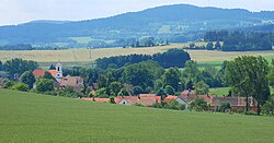 View on Předslavice | |
 Předslavice Location in the Czech Republic | |
| Coordinates: 49°7′56″N 13°56′6″E / 49.13222°N 13.93500°ECoordinates: 49°7′56″N 13°56′6″E / 49.13222°N 13.93500°E | |
| Country | |
| Region | South Bohemian |
| District | Strakonice |
| First mentioned | 1352 |
| Area | |
| • Total | 11.57 km2 (4.47 sq mi) |
| Elevation | 528 m (1,732 ft) |
| Population (2021-01-01)[1] | |
| • Total | 261 |
| • Density | 23/km2 (58/sq mi) |
| Time zone | UTC+1 (CET) |
| • Summer (DST) | UTC+2 (CEST) |
| Postal code | 387 01 |
| Website | www |

Předslavice is a municipality and village in Strakonice District in the South Bohemian Region of the Czech Republic. It has about 300 inhabitants. The municipality is situated approximately 5 km east of Volyně in the hilly landscape near the Bohemian Forest mountains.
Administrative parts[]
Villages of Kakovice, Marčovice, Úlehle and Všechlapy are administrative parts of Předslavice.
References[]
External links[]
| Wikimedia Commons has media related to Předslavice. |
| Authority control: National libraries |
|---|
This South Bohemian Region location article is a stub. You can help Wikipedia by . |
Categories:
- Villages in Strakonice District
- South Bohemian Region geography stubs