Strunkovice nad Volyňkou
Strunkovice nad Volyňkou | |
|---|---|
Municipality | |
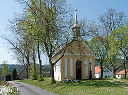 Chapel of Saint John of Nepomuk | |
 Flag  Coat of arms | |
 Strunkovice nad Volyňkou | |
| Coordinates: 49°12′27″N 13°53′35″E / 49.20750°N 13.89306°ECoordinates: 49°12′27″N 13°53′35″E / 49.20750°N 13.89306°E | |
| Country | |
| Region | South Bohemian |
| District | Strakonice |
| Area | |
| • Total | 3.78 km2 (1.46 sq mi) |
| Elevation | 442 m (1,450 ft) |
| Population (2019)[1] | |
| • Total | 128 |
| • Density | 34/km2 (88/sq mi) |
| Postal code | 387 01 |
| Website | http://www.strunkovice.cz |

Strunkovice nad Volyňkou is a village and municipality (obec) in Strakonice District in the South Bohemian Region of the Czech Republic.
The municipality covers an area of 3.78 square kilometres (1.46 sq mi), and has a population of about 120.
Strunkovice nad Volyňkou lies approximately 7 kilometres (4 mi) south of Strakonice, 50 km (31 mi) north-west of České Budějovice, and 105 km (65 mi) south of Prague.
References[]
- ^ "Population of municipalities of the Czech Republic". Czech Statistical Office. 1 January 2019.
| Wikimedia Commons has media related to Strunkovice nad Volyňkou. |
| Authority control: National libraries |
|---|
This South Bohemian Region location article is a stub. You can help Wikipedia by . |
Categories:
- Villages in Strakonice District
- South Bohemian Region geography stubs