Poland–Russia border

The modern Poland–Russia border is a nearly straight-line division between the Republic of Poland (a European Union member) and the Russian Federation (a CIS member) exclave Kaliningrad Oblast, a region not connected to the Russian mainland. It is 232 kilometres (144 mi) long. The current location and length of the border was decided in the aftermath of World War II. In 2004, it became part of the boundary of the European Union and the Commonwealth of Independent States.
History[]
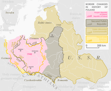
The history of the border between Poland and Russia can be traced to the early history of both nations, with one of the earliest notable incidents being the Polish king Boleslaw I's intervention in the Kievan succession crisis, 1018.[1] Following the formation of the Polish–Lithuanian Commonwealth, Poland's eastern border, most of it with the Tsardom of Muscovy (later, the Russian Empire), stretched from the Baltic Sea in the north to the Black Sea in the south.[2] During the period of partitions of Poland, which shifted the Russian borders some 300 miles (480 km) west,[3] several small Polish statelets such as the Duchy of Warsaw and the Congress Kingdom shared a border with the Russian Empire. Following World War I, the new Second Polish Republic shared a border with the Soviet Union (USSR), shaped during the Polish-Soviet War, and confirmed at the Treaty of Riga at the line Dzisna-Dokshytsy-Słucz-Korets-Ostroh-Zbrucz.[4] That border was 1,407 kilometres (874 mi) long.[5] Following World War II, the new border (see territorial changes of Poland immediately after World War II) was drawn between the People's Republic of Poland and the USSR.[6] The new Polish-Soviet border was 1,321 kilometres (821 mi) long at first, and subject to a minor modification in the 1951 Polish–Soviet territorial exchange, which reduced the border length to 1,244 kilometres (773 mi).[6][7]
Modern border[]
The modern border between Poland and Russia is regulated by a number of legal documents, many of them dating to the times of the People's Republic of Poland and the Soviet Union, including the Border Agreement between Poland and the USSR of 16 August 1945.[6][8] While the actual border line remained unchanged following the fall of the Soviet Union, the breakdown of the Soviet Union into a number of post-Soviet states transformed the Poland-Soviet Union border into a Poland-Russia, , Poland-Belarus and Poland-Ukraine border. The Poland–Russia borders were confirmed in a Polish-Russian treaty of 1992 (ratified in 1993).[8]
The Poland–Russia border is that between Poland and the Kaliningrad oblast of Russia, which is an exclave, unconnected to the rest of Russia. The border is 232 km long.[9] For most of this length, the Polish side is in the Warmian-Masurian Voivodeship; the extreme east is in the Podlaskie Voivodeship, and the westernmost segment (on the Vistula Spit) in the Pomeranian Voivodeship.[9] 210 km of the border is land and 22 km is sea.[9]
The official demarcation of the boundary was finalized March 5, 1957, in the following terms:
The Contracting Parties confirm that the existing State frontier between the Union of Soviet Socialist Republics and the Polish People's Republic in the sector adjoining the Baltic Sea, as established by the Berlin Conference in 1945, runs from frontier mark No. 1987, set up at the junction of the frontiers of the Russian Soviet Federal Socialist Republic (Kaliningrad Region), the Lithuanian Soviet Socialist Republic and the Polish People's Republic at the demarcation of the Soviet-Polish State frontier in 1946-1947, in a general westerly direction 0.5 kilometres north of the inhabited locality of Zytkiejmy, 4 kilometres north of the inhabited locality of Gołdap, 0.5 kilometres south of the inhabited locality of Krylovo, 3 kilometres south of the inhabited locality of Zheleznodorozhny, 2 kilometres south of the inhabited locality of Bagrationovsk, 4 kilometres south of the inhabited locality of Mamonovo, 7 kilometres north of the inhabited locality of Braniewo (formerly Braunsberg) and thence across the Kaliningradsky Zaliv (Zalew Wislany) and the Baltiiskaya Kosa (Mierzeja Wislana) to a point on the west shore of this spit 3 kilometres north-east of the inhabited locality of Nowa Karczma (the distances between the inhabited localities and the frontier are approximate).[10]

When Poland joined the European Union in 2004, this border became one of the borders between the European Union and the non-EU countries.[6] It is one of the five borders that Russia shares with the EU (see Border of the European Union).
As of 2008, there were three road crossings (Gołdap-Gusev, Bezledy-Bagrationovsk and Gronowo-Mamonovo) and three train crossing (Braniewo-Mamonovo, Skandawa-Zheleznodorozhny and Głomno-Bagrationovsk).[11][12][13] In 2010, the largest road crossing up to that point was opened at Grzechotki-Mamonovo.[14] More crossings are being built (Perły-Krylovo, Piaski-Baltiysk, Rapa-Ozyorsk), as the EU standards require Poland to operate at least seven for that border.[11]
In the first quarter of 2012, the Polish-Russian border saw the least traffic out of the borders Poland shares with the non-European Union countries (the others being the Poland-Ukraine border and the Poland-Belarus border).[15] For that period, a majority of the individuals crossing the borders did so for the explicit purpose of short term (usually under one day) shopping; this was the case with 45% of foreigners entering Poland, and 87% of Poles entering Russia.[15] Compared to traffic on other non-EU Polish borders, a much larger percentage (22% foreigners and 7% Poles) crossed the borders for the purpose of tourism and transit (16.5% foreigners).[15]
Border area[]
Because Kaliningrad Oblast is small, homogeneous and an exclave within the European Union, in 2011 the whole Oblast was granted the status of border area eligible to local border traffic rules. In reciprocity, the following Polish administrative districts (powiaty) were granted the same status:[16]
- in the Pomeranian Voivodeship: Puck, Gdynia, Sopot, Gdańsk city and county, Nowy Dwór Gdański, Malbork
- in the Warmian-Masurian Voivodeship: Elbląg city and county, Braniewo, Lidzbark, Bartoszyce, Olsztyn city and county, Kętrzyn, Mrągowo, Węgorzewo, Giżycko, Gołdap, Olecko
The border traffic is very high, and additional border crossings are being considered as of 2013.[17][needs update]
Border crossings[]
| Image | Russian Road/Track Name[18] | Poland Road/Track Name [18] | Type of crossing [18] | Characteristics[19] | Status [19] | Coordinates [18] |
|---|---|---|---|---|---|---|
| - | 204 | Railway | ? | 54.436690, 19.873666 | ||
| A194 | 54 | Road | Active | 54.434133, 19.897285 | ||
| P516 / E28 | S22 / E28 | Road | Active | 54.422110, 20.069206 | ||
| - | - | Road | Closed | 54.418604, 20.109728 | ||
| - | 510 | Road | Closed | 54.404207, 20.286199 | ||
| - | - | Road | Closed | 54.390875, 20.418164 | ||
| - | - | Road | Closed | 54.387013, 20.455029 | ||
| A195 | 51 | Road | Active | 54.371735, 20.660240 | ||
| - | - | Railway | ? | 54.371547, 20.698051 | ||
| - | - | Railway | ? | 54.333516, 21.303155 | ||
| - | 591 | Road | Active | 54.333177, 21.305291 | ||
| - | - | Road | Closed | 54.331327, 21.826039 | ||
| - | - | Road | Closed | 54.333504, 21.928235 | ||
| - | 65 | Road | Active | 54.341249, 22.298090 |
See also[]
| Wikimedia Commons has media related to Poland-Russia border. |
References[]
- ^ Wyprawa Kijowska Chrobrego Chwała Oręża Polskiego Nr 2. Rzeczpospolita and Mówią Wieki. Primary author Rafał Jaworski. 5 August 2006 (in Polish)
- ^ Richard C. Frucht (31 December 2004). Eastern Europe: An Introduction to the People, Lands, and Culture. ABC-CLIO. p. 170. ISBN 978-1-57607-800-6. Retrieved 12 September 2012.
- ^ David L. Ransel; Bożena Shallcross (1 July 2005). Polish Encounters, Russian Identity. Indiana University Press. p. 25. ISBN 978-0-253-34588-2. Retrieved 12 September 2012.
- ^ "Ryski traktat pokojowy - WIEM, darmowa encyklopedia". Portalwiedzy.onet.pl. Retrieved 2012-09-12.
- ^ Polska w cyfrach[permanent dead link] [in:] E. Romer Atlas Polski wspolczesnej, 1928[permanent dead link]
- ^ Jump up to: a b c d Tomasz Dubowski. Chapter Granica polsko–rosyjska jako granica zewnętrzna Unii Europejskiej. In PRZYJAZNA GRANICA NIEZBĘDNYM ELEMENTEM WZMACNIANIA STOSUNKÓW SPOŁECZEŃSTW POLSKI I ROSJI, Wydział Prawa Uniwersytetu w Białymstoku, 2011. Accessed on 11 September 2012. [1] Archived 2018-07-28 at the Wayback Machine
- ^ Andrzej Jezierski (2003). Historia Gospodarcza Polski. Key Text Wydawnictwo. p. 383. ISBN 978-83-87251-71-0. Retrieved 12 September 2012.
- ^ Jump up to: a b Janusz Szymańskii. Chapter Relacje traktatowe z Rosją po przystąpieniu Polski do UE. In PRZYJAZNA GRANICA NIEZBĘDNYM ELEMENTEM WZMACNIANIA STOSUNKÓW SPOŁECZEŃSTW POLSKI I ROSJI, Wydział Prawa Uniwersytetu w Białymstoku, 2011. Accessed on 11 September 2012. [2] Archived 2018-07-28 at the Wayback Machine
- ^ Jump up to: a b c Mały Rocznik Statystyczny Polski 2012, Główny Urząd Statystyczny, 2012. Accessed on 11 September 2012. [3]
- ^ Russia (USSR) / Poland Treaty (with annexed maps) concerning the Demarcation of the Existing Soviet-Polish State Frontier in the Sector Adjoining the Baltic Sea 5 March 1957 (retrieved from the UN Delimitation Treaties Infobase, accessed on 18/03/2002)
- ^ Jump up to: a b "Powstanie nowe przejście z obwodem kaliningradzkim. wnp.pl | Serwis Logistyka. Transport, logistyka, firmy kurierskie". Logistyka.wnp.pl. 2008-04-16. Retrieved 2012-09-12.
- ^ "Straż Graniczna - Treść" (in Polish). Strazgraniczna.pl. 2008-05-13. Retrieved 2012-09-12.
- ^ "Straż Graniczna - Treść" (in Polish). Strazgraniczna.pl. 2008-05-13. Retrieved 2012-09-12.
- ^ Agencja Reklamowa GABO (2010-12-08). "W Grzechotkach ruszyło największe przejście na granicy z Rosją". info.elblag.pl. Retrieved 2012-09-12.
- ^ Jump up to: a b c Badanie obrotu towarów i usług na zewnętrznej granicy Unii Europejskiej na terenie Polski w I kwartale 2012 roku, GŁÓWNY URZĄD STATYSTYCZNY URZĄD STATYSTYCZNY W RZESZOWIE, Warszawa-Rzeszów, 23 maja 2012 r.. Accessed 11 September 2011. [4].
- ^ Regulation (EU) No 1342/2011 of the European Parliament and of the Council of 13 December 2011 amending Regulation (EC) No 1931/2006 as regards the inclusion of the Kaliningrad oblast and certain Polish administrative districts in the eligible border area
- ^ Eastern approaches Ex-communist Europe (2013-10-08). "Poland and Kaliningrad: Small Border Traffic". The Economist. Retrieved 2013-10-18.
- ^ Jump up to: a b c d See Google Maps for respectively coordinate and OpenStreetMap.
- ^ Jump up to: a b See Google Street View for respectively coordinate.
- Poland–Russia border
- Kaliningrad Oblast
- Warmian-Masurian Voivodeship
- Borders of Poland
- Borders of Russia
- International borders