Radkovy
Radkovy | |
|---|---|
Municipality | |
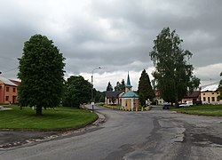 Center of the village | |
 Flag  Coat of arms | |
 Radkovy | |
| Coordinates: 49°25′59″N 17°37′10″E / 49.43306°N 17.61944°ECoordinates: 49°25′59″N 17°37′10″E / 49.43306°N 17.61944°E | |
| Country | |
| Region | Olomouc |
| District | Přerov |
| Area | |
| • Total | 2.52 km2 (0.97 sq mi) |
| Elevation | 244 m (801 ft) |
| Population (2012) | |
| • Total | 168 |
| • Density | 67/km2 (170/sq mi) |
| Postal code | 751 14 |
| Website | http://www.antee.cz/radkovy/ |

Radkovy is a village and municipality (obec) in Přerov District in the Olomouc Region of the Czech Republic.
The municipality covers an area of 2.52 square kilometres (0.97 sq mi), and has a population of 178 (as at 3 July 2006).
Radkovy lies approximately 13 kilometres (8 mi) east of Přerov, 33 km (21 mi) south-east of Olomouc, and 242 km (150 mi) east of Prague.
References[]
| Wikimedia Commons has media related to Radkovy. |
| Authority control: National libraries |
|---|
This Olomouc Region location article is a stub. You can help Wikipedia by . |
Categories:
- Villages in Přerov District
- Olomouc Region geography stubs