Rennes Metro
This article may be expanded with text translated from the corresponding article in French. (January 2022) Click [show] for important translation instructions.
|
This article relies largely or entirely on a single source. (February 2021) |
 | |
| Overview | |
|---|---|
| Native name | Métro de Rennes |
| Owner | Rennes Métropole |
| Locale | Rennes, Brittany, France |
| Transit type | Rubber-tyred metro |
| Number of lines | 1 |
| Number of stations | 15 |
| Daily ridership | 140.000 (2014) |
| Annual ridership | 32,82 million (2014) |
| Headquarters | Rennes |
| Website | www www |
| Operation | |
| Began operation | 15 March 2002 |
| Operator(s) | Service des Transports en Commun de l'Agglomération Rennaise (STAR) |
| Number of vehicles | 30 |
| Technical | |
| System length | 5.8 mi (9.3 km) |
| Track gauge | 1,620 mm (5 ft 4 in) |
| Average speed | 20 mph (32 km/h) |
| Top speed | 50 mph (80 km/h) |
The Rennes Metro (French: Métro de Rennes) (Breton: Metro Roazhon) is a light metro system serving the city of Rennes in Brittany, France.
Opened in 2002, it is based on the Siemens VAL (véhicule automatique léger or light automatic vehicle) technology. There is one line, the A Line, with fifteen stations, and an average ridership of 140,000 passengers each day.
A second line, the B Line, with an orientation north-east to south-west, is scheduled to open in 2022, between the end of April and end of May.[1]
History[]
- 1986: City Council decides to create a transport line on a north-western/south-eastern axis.
- 1989: The municipality decides to use VAL technology.
- 1992: The A Line project receives planning and environmental approvals.
- 1997: Beginning of work on Line A.
- 2002: Opening of Line A.
- 2005: Three park-and-ride lots were set up
- 2006: Creation of Korrigo card
- 2007: City Council decides to create a second metro line (B)
- 2010: The municipality decides to use CityVal technology.
- 2011: The B Line project receives planning and environmental approvals.
- 2014: Beginning of work on Line B
Map[]

Line A[]
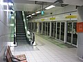
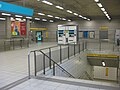
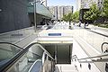
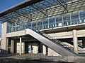
Opened on 15 March 2002, the A Line is based on the Siemens VAL (véhicule automatique léger or light automatic vehicle) technology. There is one line, the 9.4-kilometre (5.8 mi) A Line, which runs roughly northwest to southeast from J.F. Kennedy to La Poterie via Gare de Rennes (served by Gares metro station), with fifteen stations (thirteen of which are underground).
Services run between 05:20 and 00:40 each day (except Thursday, Friday and Saturday between 05:20 and 01:35), and with a waiting time of approximately 80 seconds between trains. From end to end, it takes around 16 minutes, with an average train speed of 32 km/h. All stations are equipped with platform screen doors and lifts.
The system has 30 trains, each weighing 28 tonnes and 26 metres long, with a capacity of 170 passengers.
In January 2005, three park-and-ride lots were set up, offering 900 places to motorists. Two more opened in 2006–2007, able to accommodate an additional 700 vehicles.
On 1 March 2006, a card called KorriGo was created as a supplement to the ticket system to improve the metro traffic and the city's bus network.
The line is maintained by (STAR), and managed by Keolis. It has a staff of approximately 100. It is operated from a control centre (poste de commande centralisée) situated in Chantepie. 120 cameras monitor the stations.
The station at La Poterie and viaducts on the line were designed by Foster + Partners.
With a population of just 205,000 inhabitants for city proper (in 2002), Rennes was the smallest city in the world to boast a metro until 2008 (when Lausanne Metro opened). However in 2013, 425,000 people (211 000 in Rennes) are served by the network in 43 municipalities. On average, there are 135,000 metro trips each day; this figure is expected to rise to 180,000 in coming years, leading to possible gridlock during the rush hours.
Stations[]
The station names have been chosen for the nearest existing streets or for points of interest near the station locations.
- J.F. Kennedy (former US President)
- Villejean-Université: University of Rennes 1 and University of Rennes 2
- Pontchaillou (elevated): Teaching hospital
- Anatole France (French poet and journalist)
- Sainte-Anne (French queen and Duchess of Brittany): city-center
- République: city-center
- Charles de Gaulle (former French President): city-center
- Gares (SNCF interchange): city-center
- Jacques Cartier (French navigator and explorer)
- Clemenceau (World War I French Prime Minister)
- Henri Fréville (former mayor of Rennes)
- Italie
- Triangle
- Blosne
- La Poterie (elevated)
Station signage is in French and Gallo at Charles de Gaulle station and French and Breton at Gares station.
Gallery[]

An elevated section of Metro
The subsurface station, Sainte-Anne Quais

République station
République station
Kennedy station

Charles de Gaulle station
Pontchaillou station


Plans[]

A second line, the B Line, with an orientation northeast to southwest, is scheduled to open in 2022. Nineteen 2-car CityVal trainsets have been ordered for this line.[2]
See also[]
References[]
- ^ "Métro ligne b : une mise en service au printemps". metropole.rennes.fr. Retrieved 2022-01-02.
{{cite web}}: CS1 maint: url-status (link) - ^ "Siemens selected for Rennes metro Line B". Railway Gazette International. 16 November 2010. Retrieved 2010-11-17.
External links[]
| Wikimedia Commons has media related to Rennes metro. |
- STAR – official website (in French)
- Official website for the Line B project (in French)
- Map of Rennes Métro (in French) (in French)
- Rennes at UrbanRail.net (in English)
Rapid transit in Europe | |
|---|---|
- Rapid transit in France
- Rennes
- Transport in Brittany
- VAL people movers
- 2002 establishments in France