Kharkiv Metro
| Overview | |||
|---|---|---|---|
| Native name | Харківський метрополітен Kharkivsky Metropoliten | ||
| Owner | City of Kharkiv | ||
| Locale | Kharkiv, Ukraine | ||
| Transit type | Metro/Subway | ||
| Number of lines | 3[1] | ||
| Number of stations | 30[1] | ||
| Daily ridership | |||
| Annual ridership | |||
| Chief executive | Viacheslav Volodymyrovych Salamatin, Director General [1] | ||
| Headquarters | 29 Rizdvyana Str., Kharkiv[1] | ||
| Website | Kharkiv Metro (in Ukrainian) | ||
| Operation | |||
| Began operation | 1975 | ||
| Operator(s) | Municipal Enterprise Kharkivsky Metropoliten | ||
| Number of vehicles | 65 | ||
| Train length | 5 cars | ||
| Technical | |||
| System length | 38.7 km (24.0 mi)[1] | ||
| Track gauge | 1,520 mm (4 ft 11+27⁄32 in) (Russian gauge) | ||
| Electrification | 825 V DC third rail | ||
| |||

The Kharkiv Metro (Ukrainian: Харківське метро or Харківський метрополітен) is the rapid transit system that serves the city of Kharkiv, the second largest city in Ukraine. The metro was the second in Ukraine (after Kyiv) and the sixth in the USSR when it opened on August 22 (23),[Note 1] 1975.[1][3] The metro consists of three lines which operate on 38.7 kilometres (24.0 mi) of route and serve 30 stations.[1] The system transported 223 million passengers in 2018[2] (up from 212.85 million in 2017[4]).
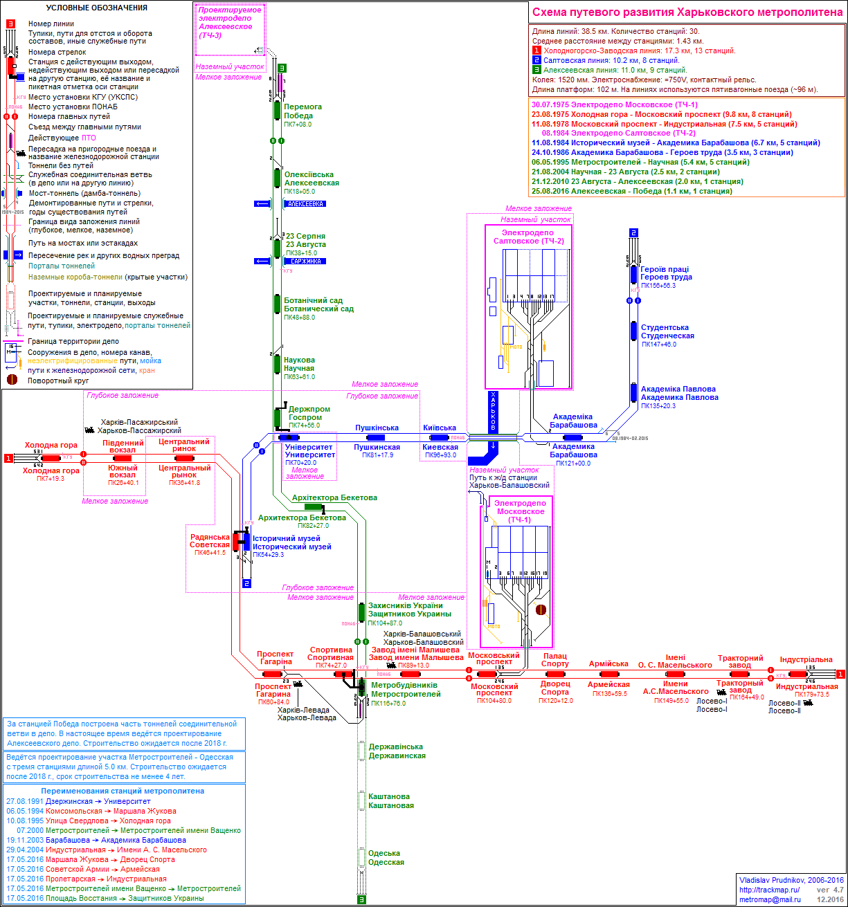
Lines and stations[]
Currently, there are 3 lines and 30 stations as follows:[1]
| No. | Name | Opened | Length | Stations |
|---|---|---|---|---|
| 1 | Kholodnohirsko-Zavodska Line | 1975 | 17.2 km[1] | 13 |
| 2 | Saltivska Line | 1984 | 10.4 km[1] | 8 |
| 3 | Oleksiivska Line | 1995 | 11 km[5] | 9 |
| TOTAL: | 38.7 km[1] | 30 | ||
Stations open at 5:30 am and close at 11:59 pm (last train departs at around 12:10 am, depending on the line) without operations at night time except for special occasions, such as the New Year's Eve, the nightly Easter service and the like.
The lines are arranged in the form of a triangle with all junction stations located in the city center and lines extending from there radially, a classic design for many ex-USSR metro systems. The whole of the system is located within the city boundaries without extending to Kharkiv Oblast, however the new Oleksiyivske Depot, which is currently under construction, will be located immediately behind the current municipal boundary.
Each line has 2 junction stations connecting it to the other 2 lines, thus providing the possibility to change from any line to any other line with a single junction. The Pivdennyi Vokzal station is integrated into the city's main railway station of the same name and provides access to all passenger platforms, cash offices and other facilities without the necessity to exit to the surface.
All stations have 2 tracks with an island platform between them. The stations and lines are located below the ground level with the exception of tracks inside depots and a single metro bridge connecting stations Kyivska and Akademika Barabashova on the Saltivska line. The bridge, however, does not provide any view of the city as it is fully enclosed with non-transparent walls and a roof. The decision to make the metro fully enclosed was made primarily with the purpose of protecting it from heavy snowfalls that often occur in winter, a decision that proved to be right on many occasions, when the metro remained but the only mode of passenger transportation functioning in the city.
Line 1 (Kholodnohirsko–Zavodska line)[]
It is the oldest and the longest line in Kharkiv Metro with the highest ridership rates and shortest time intervals. Its color is red.
The line was built along the so-called 'central axis' of the city roughly crossing it East to West. The line serves Moskovsky Prospekt, a street where one of ex-USSR biggest enterprises were located (often called the 'alley of industrial giants'), important transport hubs, the city's main stadium, etc. Basically, it replaced, partially or completely, tram and trolleybus lines with highest passenger ridership at the time of its construction. Although the ridership pattern has changed considerably since then, the line remains the most important route for passenger transportation in the city.
Kholodnohirsko-Zavodska Line starts in the heavily industrialized area, colloquially referred to as Kharkiv Tractor Plant and follows along Moskovsky Prospekt for 6 stations (from Industrialna to Turboatom), connecting the city's largest enterprises and the residential areas located nearby. Then, it continues through Zavod Imeni Malysheva, one more heavily industrialized area, and arrives at the Sportyvna station, where it is possible to change for Metrobudivnykiv of Oleksiivska line. The station also provides access to the central stadium of Kharkiv, Metalist. After that, the line follows through Prospekt Haharina, a very important transport hub located near the city center, and runs through the 'old' (historical) center for 2 stations, Maidan Konstytutsii and Tsentralnyi Rynok. Then, it passes through 2 more large transport hubs, the city's main railway station at Pivdennyi Vokzal, and a large terminal for suburban buses at Kholodna Hora.
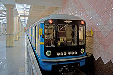
Out of the 13 stations composing the line, three are laid deep (Maidan Konstytutsii, Pivdennyi Vokzal and Kholodna Hora); all the others are laid shallow. The line is served by depot TCh-1 Moskovske with the Kharkiv's oldest vehicles of types Ezh3, Em-508T, a few trains composed of newer 81-717/714 vehicles and 5 recently modernized trains 81-710.1.
The intervals are 1.5–2 minutes during rush hours, 3–5 minutes in-between, and extend up to 15 minutes after 9 pm. During the summer vacation season (June–August), intervals can be bigger.
All trains operate the whole length of the line, from Industrialna to Kholodna Hora, with the exception of short trips from Kholodna Hora to Turboatom and from Turboatom to Industrialna. Such trips are usually made around 2-3 p.m. and late in the evening to replace trains on the line or withdraw them to the depot for the night service period, as the access to the depot is available only through Turboatom station.
Line 2 (Saltivska line)[]
Saltivska Line is historically the 2nd line of Kharkiv Metro. Although Oleksiivska Line has surpassed it in terms of line length, Saltivska Line still remains the second in terms of ridership rates and service frequency. Its color is blue.
The line cuts Kharkiv roughly along the northeast–southwest axis starting in the city center and ending in the Saltivka neighborhood in the North-East. The first plans for constructing the line appeared in mid-1970s, when the city started developing high-rise residential housing on the Saltivske Plateau, a large and flat area near the northeast boundaries of the city. The area was to become the largest residential neighborhood in Europe at the time of its construction, however it was supposed to be located far from main points of passenger attraction, such as industrial areas, transport hubs, leisure facilities and the like. Thus, the need for a strong link between the neighborhood and other parts of the city became evident.
The construction of the line was performed simultaneously with development of Saltivka, which helped cutting the cost of construction considerably. The section from Akademika Barabashova to Heroiv Pratsi was constructed using the cut-and-cover method for tunnels, which is the cheapest one. The stations located on the line are acclaimed for their concise, yet unique and attractive design. The line also features Kharkiv Metro's only metro bridge.
Initially, it was planned to fork the line at Akademika Barabashova station so that there would be two branches, one of them passing Saltivka from south to north (which is currently in operation) and the other one passing the neighborhood from west to east. According to initial plans, half of the trains arriving from the city center would then follow the south–north branch and the other half would follow the west–east one, alternating in sequence. The south–north branch was never constructed due to financial difficulties and is currently substituted by route 24 of .
Saltivska Line starts in the "old" (historical) center of the city at station Istorychnyi Muzei which also provides a transfer to Maidan Konstytutsii of Kholodnohirsko-Zavodska Line. After leaving the station, the line follows a long and steep ascend to the Universytet station located in the heart of the "new" (business) center, under one of the largest squares in Europe, . It provides a transfer to Derzhprom station of Oleksiivska Line. Then, the line passes one more station in the city center, Pushkinska, and performs a steep dive into the city's lowest part, Zhuravlivka. After a short visit to Zhuravlivka at Kyivska, the line crosses the Kharkiv River via the metro bridge and enters the Saltivka neighborhood. The rest of the stations, from Akademika Barabashova to Heroiv Pratsi are located within the neighborhood, laid approximately at the same (shallow) depth.
The line is characterized by a severe increase of ridership during the rush hours and strong influence of Barabashovo Market, which claims to be the largest market in Europe (located near Akademika Barabashova station, which gave the market its name). The market operates roughly 8 a.m. to 3 p.m., increasing the passenger traffic considerably during the morning rush hours, especially on Wednesday, traditionally the discounts day. The traffic on the line also has a distinct student ridership pattern: the most of Kharkiv higher educational establishments are located around Istorychnyi Muzei, Universytet, and Pushkinska stations, but the respective student dormitories are located near Studentska station. Heroiv Pratsi is an important transport hub providing connections to the city's most important tram routes and serving a bus station for suburban routes.
Out of the 8 stations on the line, three are laid deep (Istorychnyi Muzei, Universytet, and Pushkinska); all the others are laid shallow. Pushkinska is the deepest station in the system at 30 meters (98 ft) underground. The line is served by depot TCh-2 Saltivske with vehicles of types 81-717/714 and the only train set of . The access to the depot is provided via Akademika Barabashova station.
The intervals are 3–5 minutes during rush hours, 5–6 minutes in-between, and extend up to 20 minutes after 9 pm. During the summer vacation season (June–August), intervals can be bigger.
All trains operate the whole length of the line, from Istorychnyi Muzei to Heroiv Pratsi. Starting from 2001, because of power supply issues, every fourth train that operated on the line between rush hours served only the Istorychnyi Muzei - Akademika Barabashova segment. The practice was abandoned by the end of 2002, when power supply normalized.
Line 3 (Oleksiivska line)[]
Oleksiivska line is historically the third line in the system and the second longest line in the Metro. The line does not have an individual depot; it is served by the same depot which serves the Holodnohirsko-Zavodska line, though a new depot for the line is under construction. In August 2016, the Peremoha station became the first Kharkiv Metro station with disabled access.
[]
The line is supposed to have a similar route to the tram route 26. Construction of the line is sheduled to start after the opening of and stations on the Oleksiivska line.
Ticketing[]
A single ride costs 8.00 hryvnia regardless of destination and number of transits within the metro.
The ride can be paid by:
- paper barcode tickets;
- contactless card E-Ticket;
- contactless bank card (as well as a smartphone or other NFC-enabled device) on blue-coloured turnstiles directly;
E-Ticket card or paper barcode tickets can be purchased using terminals installed on stations. Terminals accept cash only. E-Ticket card can be also used in Kharkiv tram, trolleybus and municipal red bus.
History[]


Initial plans for a rapid transit system in Kharkiv were made when the city was a capital of the Ukrainian Soviet Socialist Republic. However, after the capital moved to Kyiv in 1934 and Kharkiv suffered heavy destruction during World War II, a rapid transit system was dropped from the agenda. In the mid-1960s, the existing mass transit system became too strained, and construction of the metro began in 1968.
Seven years later, on 23 August 1975, the first eight-station segment of 10.4 kilometres (6.5 mi) was put into use. It is claimed that the metro does not have the beautiful and excessive decorations that stations in Moscow and Saint Petersburg[citation needed] Metros show, yet they do make the best of mid-1970s and later styles. While a metro token is shown below, since 2012 they can no longer be used in Kharkiv. Tokens were also used in the Kyiv metro until late 2019.[6]
Kharkiv Metro operations were suspended on 17 March 2020 to prevent coronavirus COVID-19 spread.[7][8] To compensate for the lack of metro, the city administration implemented a series of changes in the tram, trolleybus, and bus routes of the city.[9][10][11] The metro was reopened on 25 May 2020; face masks or respirators were mandated to wear for passengers.[12]
Facts and numbers[]
As for 2020, the Kharkiv Metro had a daily passenger traffic of 350,000 passengers.[2]
2300 eployees work in metro.[13]
Because of the city's uneven landscape, the metro stations are located on varying depths. Six of the system's 30 stations are deep level stations, and the remaining are shallow. Of the former, all but one are pylon type, and the latter are of column type. The shallow stations are fourteen pillar-trispans and eight single vaults. Kharkiv was the first metro to exhibit the single vault design of the shallow type (for technical details, see Skhodnenskaya).
The metro is served by two depots which have a total of 320 carriages forming 59 five-car trainsets[citation needed] (all of the platforms are exactly 100 metres (330 ft) long). In 2015, new trains were introduced to the metro.[14]
The metro was directly subordinated to the Ministry of Transport of Ukraine. Unlike the Kyiv Metro, Kharkiv is not privatised and owned by a municipal company. In 2009, the Ministry transferred the metro to the city administration.
In 2020, Chinese manufacturer CRRC Tangshan was selected as the winner of a contract to supply eight five-car trainsets for the Kharkiv metro. It is scheduled for delivery in 2022. The trains will be 96.7 m long and 2,700 mm wide with a maximum speed of 80 km/h. The €45m deal announced on 27 May includes the provision of spare parts, tools and support services.[15]
See also[]
Notes[]
- ^ The official opening ceremony was held on August 22, open for general public on August 23.
References[]
- ^ Jump up to: a b c d e f g h i j k Official Web Site (24 June 2019) (in Ukrainian)
- ^ Jump up to: a b c АРХІВ. ПАСАЖИРСЬКІ ПЕРЕВЕЗЕННЯ [PASSENGER TRANSPORTATION IN KHARKIV REGION - ARCHIVE]. kh.ukrstat.gov.ua (in Ukrainian). Головне управління статистики у Харківській області [Head Department of Statistics for Kharkiv Region]. Retrieved 2019-06-24.
- ^ "Первая очередь (1968-1975) | Мир метро". Мир метро. Retrieved 2020-04-02.
- ^ Пасажирські перевезення у 2017 році [Passenger Transportation in 2017]. kh.ukrstat.gov.ua (in Ukrainian). Головне управління статистики у Харківській області [Head Department of Statistics for Kharkiv Region]. Retrieved 2019-06-24.
- ^ Метро. Алексеевская линия [Metro. Oleksiivska Line]. gortransport.kharkov.ua (in Russian). Харьков транспортный [Kharkov Trnasportny]. 2018. Retrieved 2019-06-24.
- ^ "Kyiv Metro removes tokens, advises to switch to new fare collection systems". www.unian.info. Retrieved 2020-01-29.
- ^ "Протокол №3 позачергового засідання міської комісії Про невідкладні заходи щодо протидії розповсюдженню коронавірусу COVID-19 на території м. Харкова". Офіційний сайт Харківської міської ради, міського голови, виконавчого комітету. 2020-03-17. Retrieved 2020-04-03.
- ^ "Продлен запрет на работу Харьковского метрополитена | STATUS QUO". STATUS QUO. 2020-04-02. Retrieved 2020-04-02.
- ^ "У Харкові вводяться тимчасові зміни маршрутів наземного пасажирського транспорту | ОПЕРАТИВНА ІНФОРМАЦІЯ". Офіційний сайт Харківської міської ради, міського голови, виконавчого комітету. 2020-03-17. Retrieved 2020-04-02.
- ^ "Про тимчасову зміну маршрутів міського наземного пасажирського транспорту". Офіційний сайт Харківської міської ради, міського голови, виконавчого комітету. 2020-03-17. Retrieved 2020-04-02.
- ^ "Про внесення змін до наказу № 67 від 17.03.2020 року «Про тимчасову зміну маршрутів міського наземного пасажирського транспорту»". Офіційний сайт Харківської міської ради, міського голови, виконавчого комітету. 2020-03-18. Retrieved 2020-04-02.
- ^ Subway resumes work in Kyiv, Kharkiv: new safety rules, explained (Photo), UNIAN (25 May 2020)
- ^ "Офіційний сайт КП «Харківський метрополітен»". www.metro.kharkov.ua. Retrieved 2021-09-13.
- ^ Kharkiv metro inaugurates trainset, Railway Gazette International (24 August 2015)
- ^ "CRRC wins Kharkiv metro train contract". Railway Gazette International.
External links[]
| Wikimedia Commons has media related to Kharkiv Metro. |
- Kharkiv Metro – official site (in Ukrainian)
- Kharkiv Metro – unofficial website (in Russian)
- Kharkiv Metro track map
- Kharkiv Metro at UrbanRail.net
- Kharkiv Metro at Subways.net
- Metro soyuza – Photographs (in German and Russian)
- Kharkiv Transportny – Popular site with resources and images (in Russian)
- Photos of Kharkiv Metro — on virtual photo gallery Metro (in Russian and Ukrainian)
| show Rapid transit in Europe |
|---|
- Kharkiv Metro
- Underground rapid transit in Ukraine
- Transport in Kharkiv