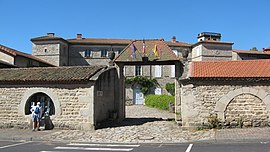
Saint-Dier-d'Auvergne
Saint-Dier-d'Auvergne | |
|---|---|
 The town hall in Saint-Dier-d'Auvergne | |
 Coat of arms | |
show Location of Saint-Dier-d'Auvergne | |
 Saint-Dier-d'Auvergne | |
| Coordinates: 45°40′34″N 3°28′59″E / 45.676°N 3.483°ECoordinates: 45°40′34″N 3°28′59″E / 45.676°N 3.483°E | |
| Country | France |
| Region | Auvergne-Rhône-Alpes |
| Department | Puy-de-Dôme |
| Arrondissement | Clermont-Ferrand |
| Canton | Billom |
| Intercommunality | Billom Communauté |
| Government | |
| • Mayor (2020–2026) | Nathalie Sessa |
| Area 1 | 20.15 km2 (7.78 sq mi) |
| Population (Jan. 2018)[1] | 530 |
| • Density | 26/km2 (68/sq mi) |
| Time zone | UTC+01:00 (CET) |
| • Summer (DST) | UTC+02:00 (CEST) |
| INSEE/Postal code | 63334 /63520 |
| Elevation | 416–700 m (1,365–2,297 ft) (avg. 445 m or 1,460 ft) |
| 1 French Land Register data, which excludes lakes, ponds, glaciers > 1 km2 (0.386 sq mi or 247 acres) and river estuaries. | |
Saint-Dier-d'Auvergne (French pronunciation: [sɛ̃ dje dovɛʁɲ]) is a small village-town in the Puy-de-Dôme department in Auvergne region in central France.[2] The town of Saint-Dier-d'Auvergne is located in the township of Saint-Dier-d'Auvergne part of the district of Clermont-Ferrand. The area code for Saint-Dier-d'Auvergne is 63334 (also known as code INSEE), and the Saint-Dier-d'Auvergne zip code is 63520.[3]
Geography[]
The altitude of the city hall of Saint-Dier-d'Auvergne is approximately 445 meters. The Saint-Dier-d'Auvergne surface is 20.15 km ². The latitude and longitude of Saint-Dier-d'Auvergne are 45.676 degrees North and 3.481 degrees East. Nearby cities and towns of Saint-Dier-d'Auvergne are : Estandeuil (63520) at 3.07 km, Ceilloux (63520) at 3.68 km, Saint-Flour (63520) at 3.97 km, Domaize (63520) at 4.32 km, Mauzun (63160) at 4.95 km, Saint-Jean-des-Ollières (63520) at 5.01 km, Trézioux (63520) at 5.21 km, Fayet-le-Château (63160) at 5.43 km. (The distances to these nearby towns of Saint-Dier-d'Auvergne are calculated as the crow flies)[3]
Population and housing[]
The population of Saint-Dier-d'Auvergne was 551 in 1999, 541 in 2006 and 550 in 2007. The population density of Saint-Dier-d'Auvergne is 27.30 inhabitants per km2. The number of housing of Saint-Dier-d'Auvergne was 404 in 2007. These homes of Saint-Dier-d'Auvergne consist of 256 main residences, 112 second or occasional homes and 36 vacant homes.[3]
See also[]
References[]
- Tripadvisor.com/Restaurants
- Map-france.com/Saint-Dier-d'Auvergne
- Booking.com/saint-dier-dauvergne.html
- INSEE commune file
- ^ "Populations légales 2018". INSEE. 28 December 2020.
- ^ "Commune de Saint-Dier-d'Auvergne (63334) − COG| Insee". www.insee.fr. Retrieved 2020-06-13.
- ^ Jump up to: a b c "SAINT-DIER-D'AUVERGNE - Map of Saint-Dier-d'Auvergne 63520 France". www.map-france.com. Retrieved 2020-06-13.
| Wikimedia Commons has media related to Saint-Dier-d'Auvergne. |
- Communes of Puy-de-Dôme
- Puy-de-Dôme geography stubs


