Suchá Lhota
Suchá Lhota | |
|---|---|
Municipality | |
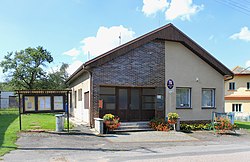 Municipal office | |
 Flag | |
 Suchá Lhota | |
| Coordinates: 49°52′47″N 16°10′33″E / 49.87972°N 16.17583°ECoordinates: 49°52′47″N 16°10′33″E / 49.87972°N 16.17583°E | |
| Country | |
| Region | Pardubice |
| District | Svitavy |
| Area | |
| • Total | 2.18 km2 (0.84 sq mi) |
| Elevation | 426 m (1,398 ft) |
| Population (2006) | |
| • Total | 93 |
| • Density | 43/km2 (110/sq mi) |
| Postal code | 570 01 |

Suchá Lhota is a village and municipality (obec) in Svitavy District in the Pardubice Region of the Czech Republic. The municipality covers an area of 2.18 square kilometres (0.84 sq mi), and has a population of 93 (as at 2 October 2006).
Suchá Lhota lies approximately 26 kilometres (16 mi) north-west of Svitavy, 34 km (21 mi) south-east of Pardubice, and 128 km (80 mi) east of Prague.
References[]
| Wikimedia Commons has media related to Suchá Lhota. |
| Authority control: National libraries |
|---|
This Pardubice Region location article is a stub. You can help Wikipedia by . |
Categories:
- Villages in Svitavy District
- Pardubice Region geography stubs