Trpín (Svitavy District)
This article does not cite any sources. (March 2016) |
Trpín | |
|---|---|
Village | |
 | |
 Flag  Coat of arms | |
 Trpín Location in the Czech Republic | |
| Coordinates: 49°35′34″N 16°24′11″E / 49.59278°N 16.40306°ECoordinates: 49°35′34″N 16°24′11″E / 49.59278°N 16.40306°E | |
| Country | Czech Republic |
| Region | Pardubice |
| District | Svitavy |
| First mentioned | 1349 |
| Government | |
| • Mayor | Miloslav Tocháček |
| Area | |
| • Total | 12.48 km2 (4.82 sq mi) |
| Elevation | 598 m (1,962 ft) |
| Population (2014-01-01) | |
| • Total | 426 |
| • Density | 34/km2 (88/sq mi) |
| Time zone | UTC+1 (CET) |
| • Summer (DST) | UTC+2 (CEST) |
| Postal code | 569 74 - 569 92 |
| Website | www.trpin.cz |

Trpín is a village and municipality in the Svitavy District, in the Pardubice Region of the Czech Republic located about 17 km southeast of Polička. The population as of 2007 was 436.[1]
Parts of the municipality[]
- Trpín
History[]
First written mention of the village dates from 1349.
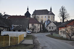
Sights[]
- Church of St. Wenceslas
Partner city[]
 Palkonya, Hungary
People from Trpín[]
- professor Otakar Sedloň, academic painter, 30.8.1885 Trpín - 18.10.1973 Praha
Publications[]
- Josef Krušina: Dějiny Trpína a okolí (1948)
| Wikimedia Commons has media related to Trpín (Svitavy District). |
| Authority control: National libraries |
|---|
This Pardubice Region location article is a stub. You can help Wikipedia by . |
Categories:
- Villages in Svitavy District
- Pardubice Region geography stubs