Transport in Tel Aviv


The Tel Aviv transportation system is seen as the hub of the Israeli transport network in terms of road, rail, and air transport. The Israeli road network partly centers on the city, with some of the country's largest highways passing through or running to the city. The city forms a major part of the country's rail network, whilst Ben Gurion International Airport located near the city is the country's largest airport. There is also a strong public transport system within the city, based primarily on bus transportation.
Local and national[]
Cycling[]

Tel Aviv Municipality is trying to encourage the use of bicycles in the city. Plans called for expansion of the paths to 100 kilometers (62.1 mi) by 2009.[1]
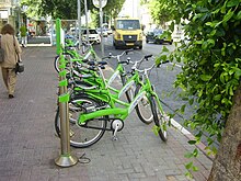
Tel-O-Fun[]
In April 2011, Tel Aviv municipality launched Tel-O-Fun, a bicycle sharing system, in which 150 stations of bicycles for rent were installed within the city limits.[2] As of October 2011, there are 125 active stations, providing more than 1,000 bicycles. As of April 2011 the municipality has completed construction of about 100 km (62 mi) of bicycle paths.
Ofnidan (Greater Tel Aviv Cycle Network)[]
As of 2021, construction was underway on Ofnidan, a cycle network of seven routes connecting the cities of the Gush Dan, with some segments open.
Electric Scooters[]
Regulations[]
In August 2019, the city of Tel Aviv planned regulations electrical scooter companies. These conditions included a limit of 2,500 scooters in the city per company, deactivating the scooter alarms during nighttime, designation of parking areas, and restricting minors from using the scooters.
Since January 1, 2020, all electrical scooter companies are required to have license plates on the back of each scooter. In addition, all electrical scooter companies are required to recycle the batteries of discontinued scooters in an effort to minimize e-waste.
Since February 1, 2020, electrical scooters are banned from entering areas for pedestrians only. The scooters automatically turn off upon entering the zones, and will be limited to speeds of 15 km/hr upon entering zones deemed high for pedestrian traffic.
As of June 15, 2020, all electrical scooter companies must provide helmets with each scooter.[3]
Rail transport[]
| show Railways in the Tel Aviv area |
|---|

Tel Aviv has four train stations along the Ayalon Highway. The stops are from north to south: Tel Aviv University, Tel Aviv Savidor Central, Tel Aviv HaShalom (near the Azrieli Center shopping mall) and Tel Aviv HaHagana (near the central bus station). It is estimated that more than a million people travel by train from the surrounding cities to Tel Aviv each month.[citation needed]
Since the completion of the Ayalon Highway railway section in 1993, Tel Aviv has been the central hub for rail transport in Israel. The Savidor Central Railway Station alone handled approximately 38,000 passengers a day in summer 2009.[citation needed] Railway lines from Tel Aviv include Israel Railways's main line, running from Beersheba to Nahariya, as well as lines to Ashkelon, Modi'in, Rishon LeTziyon, Kfar Saba and Jerusalem. Most trains stop at all stations in Tel Aviv, except for some trains to and from Be'er Sheva that do not reach Tel Aviv University, some trains bound for Rishon LeZion HaRishonim and late night trains that only stop at Tel Aviv Savidor Central. All stations of Israel Railways, other than Dimona, are directly reachable from Tel Aviv.[4]
Bus transport[]
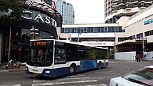

The new Tel Aviv Central Bus Station is the biggest bus terminal in Israel, 400 meters from the old central bus station. The main bus network in Tel Aviv is operated by Dan Bus Company, with some metropolitan lines operated by Egged, Kavim, Afikim, and Metropoline. Few lines are dedicated to Tel Aviv, most lines serving Tel Aviv have their terminus in one of the neighboring cities. The Egged Bus Cooperative, the world's second-largest bus company, provides most intercity transportation.[5] Intercity transportation to certain destinations is offered by other companies, including Kavim, Dan, Metropoline, Superbus and Afikim.
Following is a partial list of destinations for every bus company:
| Company name | Major destinations in Gush Dan | Major large distance destinations | Notes |
|---|---|---|---|
| Egged | Herzliya, Raanana, Kfar Saba, Ramat Hasharon, Holon, Rishon LeTziyon, Rehovot, Yehud, Bat Yam | Jerusalem, Haifa, all destinations in the North, Hadera, Ashkelon, Eilat | Egged will operate the routes to Kfar Saba, Raanana, Herzliya and Ramat HaSharon until mid 2018. |
| Dan | Ramat Gan, Bnei Brak, Givatayim, Petah Tikva, Bat Yam, Holon, Rishon LeTziyon, Ramat Hasharon | N/A | |
| Superbus | N/A | Bet Shemesh | |
| Kavim | Kiryat Ono, Yehud, Or Yehuda, Ramla, Lod | El'ad, Shoham, Modi'in, Netanya | |
| Metropoline | Herzliya, Raanana, Kfar Saba, Ramat Hasharon | Be'er Sheva, Kiryat Gat, Sderot, Netivot | Metropoline will start to serve Holon, Bat Yam and Netanya in mid 2018. |
| Afikim | Petah Tikva, Rosh HaAyin, Kafr Qasim | Ashdod, Yavne, Ariel | |
| Nateev Express | N/A | Netanya | Nateev Express will operates the routes to Netanya ultil mid 2018. |
| Dan | N/A | Eshkol Regional Council | A single bus route from Tel Aviv to Eshkol Regional Council |
Most intercity lines use the central bus station or the 2000 Terminal (Arlozorov Terminal) located next to the Tel Aviv Central railway station. The 2000 Terminal is the second most important terminal in Tel Aviv, and all lines from the central bus station heading North stop there.
Other important terminals include:
- The near the Carmel Market, used by many Dan lines and a few Kavim and Egged metropolitan lines to various parts of Gush Dan
- The near the power station by the same name, used by Dan lines to other parts of Tel Aviv, Holon, Rishon LeTziyon and Bat Yam, Kavim lines to Or Yehuda and Kiryat Ono, and Egged lines to Holon and Rishon LeTziyon
- The , a terminus of several urban Dan lines on the northeastern outskirts of the city
A new Bus service financed by the city and a few participating municipalities in the area, provides free bus transport during Shabat, when regular service does not work. This service, called "Na'im Busofash" ("Naim" means moving and also pleasant, Sofash is short for Sof Shavu'a = weekend) and provides bus service in the city and to/from Givatayim, Kiryat Ono, Ramat HaSharon, Shoham and Yehud-Monosson. There are 7 lines (numbers 705-711) every 20 minutes, service is on Fridays 5:00 pm to 02:00 am and Saturdays 09:00 am to 5:00 pm (line 711 has different hours and frequency). Since it's not an official government service, they cannot charge money for the rides, and therefore it's free.
Light rail and metro[]
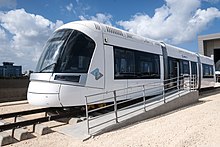
A light rail/subway system is for the Tel Aviv metropolitan area is under construction, The Red Line of the project is expected to be operation in 2022 and will pass through south-central Tel Aviv. A second line, the Green Line, will pass through the heart of Tel Aviv.
The Red Line starts at Petah Tikva's Central Bus Station, east of Tel Aviv and follows the Jabotinsky Road (Route 481) westwards at street level. At the point where Jabotinsky Road and Highway 4 intersect the line drops into a tunnel for 10 km (6.21 mi) through Bnei Brak, Ramat Gan and Tel Aviv and emerges again to street level just before Jaffa, where it turns southwards towards Bat Yam.
A metro, comprising three additional lines, M1, M2 and M3, is also planned.
Road transport[]

Many major routes of the national road network pass through or end in Tel Aviv, a transportation hub. The main road access route to Tel Aviv is the Ayalon Highway (Highway 20), which runs along the eastern side of the city from north to south along the Ayalon River riverbed, dividing for the most part Tel Aviv and Ramat Gan. Driving south on the Ayalon gives access to Highway 1, leading to Ben Gurion International Airport and Jerusalem. Within the city, the main routes are King George Street, Allenby Street, Ibn Gabirol Street, Dizengoff Street, Rothschild Boulevard, and in Jaffa the main route is Jerusalem Boulevard. Namir Road connects the city to Highway 2, Israel's main north–south highway, and Begin/Jabotinsky Road, which provides access from the east through Ramat Gan, Bnei Brak and Petah Tikva. Tel Aviv, accommodating about 500,000 commuter cars daily, suffers from increasing congestion. In 2007, the Sadan Report recommended the introduction of a congestion charge similar to that of London in Tel Aviv as well as other Israeli cities. Under this plan, road users travelling into the city would pay a fixed fee.[6]
International[]
Air transport[]

Tel Aviv's domestic airport is Sde Dov in the northwestern part of the city. Sde Dov is slated to close because it occupies prime coastal real estate near the upscale Ramat Aviv neighborhood.[7] In the future all services to Sde Dov will transfer to Ben Gurion International Airport, Israel's main international airport, close to the city of Lod and 15 kilometres (9 mi) southeast of Tel Aviv. Because it is close to Tel Aviv, Ben Gurion International Airport is often referred to as Tel Aviv International Airport even though it is not part of any municipal jurisdiction.
Under current plans Sde Dov airport may eventually close and be replaced by a new international airport built on an artificial island off the shore of Rishon LeZion.[8][9]
Future plans[]
In early 2008, Tel Aviv Municipality announced a pilot scheme to build charging stations for electric cars. Initially, five charging points will be built, and eventually 150 points will be set up across the city as part of the Israeli electric car project, Project Better Place.[10] Furthermore, battery replacement points will be located at the city's entrances.
There is an effort to create a system of bus priority for certain lines that are heavily used and that run through congested areas. This effort is being led by transportation professionals and environmental groups, such as Transport Today and Tomorrow, which seeks to improve sustainable transportation in Israel. Buses are currently subject to the same traffic as cars and creating specific lanes and other forms of prioritization would help to alleviate this problem.
References[]
- ^ "City wheels in bicycle rental plan". The Jerusalem Post. 2008-01-21. Retrieved 2008-01-31.
- ^ "Tel-O-Fun". Tel Aviv Municipality. Retrieved 10 May 2011.
- ^ "Electric Scooters Tel Aviv". Presstelaviv. Retrieved 2020-03-30.
- ^ Route map on the Israel Railways website. Retrieved on 2008-11-23
- ^ Solomon, Shoshanna (2001-11-01). "Facets of the Israeli Economy – Transportation". Israel Ministry of Foreign Affairs. Retrieved 2007-07-17.
- ^ Wrobel, Sharon (2008-08-01). "Public transportation to be overhauled". Jerusalem Post. Retrieved 2008-01-27.
- ^ Bar-Eli, Avi (2006-11-30). "Sde Dov to be vacated, state gets half of Big Bloc". Haaretz. Retrieved 2007-07-17.
- ^ "Island airport plan cleared for takeoff". The Jerusalem Post. Retrieved 2013-09-07.
- ^ Efrati, Ido (2012-09-01). "Airport at sea, or castle in the air? - Israel News | Haaretz Daily Newspaper". Haaretz.com. Retrieved 2013-09-07.
- ^ "Tel Aviv commits to electric car". Globes. 2008-01-17. Retrieved 2008-01-17.
- Transport in Tel Aviv