Waldweistroff
From Wikipedia, the free encyclopedia
Commune in Grand Est, France
Waldweistroff | |
|---|---|
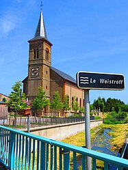 The church in Waldweistroff | |
 Coat of arms | |
 Waldweistroff  Waldweistroff | |
Coordinates:  49°21′36″N 6°29′48″E / 49.36°N 6.4967°E / 49.36; 6.4967Coordinates: 49°21′36″N 6°29′48″E / 49.36°N 6.4967°E / 49.36; 6.4967 49°21′36″N 6°29′48″E / 49.36°N 6.4967°E / 49.36; 6.4967Coordinates: 49°21′36″N 6°29′48″E / 49.36°N 6.4967°E / 49.36; 6.4967 | |
| Country | France |
| Region | Grand Est |
| Department | Moselle |
| Arrondissement | Thionville |
| Canton | Bouzonville |
| Intercommunality | |
| Government | |
| • Mayor (2014-2020) | Danielle Niedercorn |
| Area 1 | 7.73 km2 (2.98 sq mi) |
| Population (Jan. 2018)[1] | 498 |
| • Density | 64/km2 (170/sq mi) |
| Time zone | UTC+01:00 (CET) |
| • Summer (DST) | UTC+02:00 (CEST) |
| INSEE/Postal code | 57739 /57320 |
| Elevation | 224–291 m (735–955 ft) (avg. 240 m or 790 ft) |
| 1 French Land Register data, which excludes lakes, ponds, glaciers > 1 km2 (0.386 sq mi or 247 acres) and river estuaries. | |

Waldweistroff (German: Waldweisdorf) is a commune in the Moselle department in Grand Est in north-eastern France.
It is located on the German border.
Population[]
| Year | Pop. | ±% |
|---|---|---|
| 2006 | 393 | — |
| 2007 | 406 | +3.3% |
| 2008 | 417 | +2.7% |
| 2009 | 439 | +5.3% |
| 2010 | 462 | +5.2% |
| 2011 | 484 | +4.8% |
| 2012 | 492 | +1.7% |
| 2013 | 495 | +0.6% |
| 2014 | 495 | +0.0% |
| 2015 | 494 | −0.2% |
| 2016 | 493 | −0.2% |
See also[]
| Wikimedia Commons has media related to Waldweistroff. |
References[]
- ^ "Populations légales 2018". INSEE. 28 December 2020.
show
| |
|---|---|
| Prefecture |
|
| Subprefectures |
|
| Other |
|
This Arrondissement of Thionville geographical article is a stub. You can help Wikipedia by . |
- v
- t
Retrieved from ""
Categories:
- Communes of Moselle (department)
- Thionville arrondissement geography stubs
Hidden categories:
- Articles with short description
- Short description is different from Wikidata
- Infobox mapframe without OSM relation ID on Wikidata
- Coordinates on Wikidata
- Pages using infobox settlement with image map1 but not image map
- Articles containing German-language text
- Commons category link from Wikidata
- Articles with BNF identifiers
- All stub articles
- Pages using the Kartographer extension